Introduction to GIS: Geographic Information Systems Fundamentals

Вставка
- Опубліковано 8 чер 2014
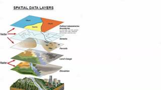
- GIS, which stands for Geographic Information Systems, is a powerful tool that helps urban planners make better decisions about urban environments. This video provides an introduction to GIS as a foundation for learning how to use GIS software such as ESRI's ArcGIS.
Want to learn more about the basics of GIS? Join course instructor Mike Ernst in a series of 5 GIS courses for beginners, focusing on ESRI’s ArcGIS software and its applications for GIS mapping. Students will learn how to make a thematic map, configure data sets, and import spatial and nonspatial data into ArcGIS.
This video is an excerpt from the first course in this series, "GIS Fundamentals: An Introduction." Watch the full course here: courses.planetizen.com/course...
#GIS #geographicinformationsystems #urbanplanning
Subscribe to Planetizen Courses' channel and enable notifications to keep up with the latest urban planning videos: ua-cam.com/users/PlanetizenC...
Planetizen Courses offers hundreds of online urban planning video courses taught by trusted professional planners. Sign up for access to cutting edge urban planning and urban design video courses on computer, phone, or tablet:
courses.planetizen.com/course...
Follow Planetizen Courses on Twitter: / plnzcourses
Follow Planetizen Courses on LinkedIn: / planetizen-courses
5 courses on GIS Fundamentals: courses.planetizen.com/track/...


Thank you for not having a monotone voice
Nyc Tutorial series
This is so fascinating!
I want to know more about this.
Interesting
Woah
I'm not sure about the noise in your background though...
wow