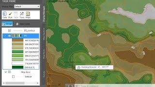
This may have worked for _C3D 2015_, -but in _C3D 2017_, you end up getting an import conflict if your C3D project coordinate system (CS) doesn't match IW's default --*--LL84*; *WGS84-*- CS.- [see below] I've also found that if my CS is anything other than a *UTM CS*, *Bing* doesn't display the satellite/aerial imagery at all. Oh... and one last thing, _C3D 2017_ now requires you to pick both the *.shp* _and_ the *.prj* files created by the *_MAPEXPORT_* command when importing to *IW 360 Model Builder.* [addendum] - apparently the error I speak of above was a result of keeping _InfoWorks 360_ open. Once closed there were no issues importing the model regardless of the CS I was using (at least insofar as I was using a UTM CS).
Bartels, when I create a KMZ file using CIVIL 3D, and this KMZ file is called from Google Earth, the view zooms out instead of zooms in as any other KMZ file works, as your KMZ file did for example. Do you know if I have a wrong setting I could fix? Thank you.
Jeff, do you have a video on a way of doing this without Infraworks? Thanks for all your great content. In my opinion you have the best C3D vids on YT.
hi Jeff i have tried to export the .kml to google earth but when i do it never aligns up with the then work area it ends up in the middle of the ocean or the other side of the world could you help with where i am going wrong ?
Is there a way to find a location in a blank drawing? For example, if I start a blank drawing, can i navigate to a location? Every time i use the Edit Location Button, it seems to reorient the map but not my location. Basically, then my map doesn't jive with state plane coordinates. Thanks


Civil 3D works flawlessly on your machine,
What are the specs of your computer please? RAM, processor, VGA card,
Very good video, many thanks
Bravo!!!In China,there is no video of Civil 3d professional like yours.Than you!
Thank you Bartels for you video.
You are welcome! I'm glad it was helpful!
Just Brilliant !!!
This may have worked for _C3D 2015_, -but in _C3D 2017_, you end up getting an import conflict if your C3D project coordinate system (CS) doesn't match IW's default --*--LL84*; *WGS84-*- CS.- [see below]
I've also found that if my CS is anything other than a *UTM CS*, *Bing* doesn't display the satellite/aerial imagery at all.
Oh... and one last thing, _C3D 2017_ now requires you to pick both the *.shp* _and_ the *.prj* files created by the *_MAPEXPORT_* command when importing to *IW 360 Model Builder.*
[addendum] - apparently the error I speak of above was a result of keeping _InfoWorks 360_ open. Once closed there were no issues importing the model regardless of the CS I was using (at least insofar as I was using a UTM CS).
Bartels, when I create a KMZ file using CIVIL 3D, and this KMZ file is called from Google Earth, the view zooms out instead of zooms in as any other KMZ file works, as your KMZ file did for example. Do you know if I have a wrong setting I could fix?
Thank you.
Which is better to georeference bing maps or google earth?
Jeff, do you have a video on a way of doing this without Infraworks? Thanks for all your great content. In my opinion you have the best C3D vids on YT.
whoa, i dont know that civil 3d could do this much...
Coolest video ever Jeff it's cool
hi Jeff i have tried to export the .kml to google earth but when i do it never aligns up with the then work area it ends up in the middle of the ocean or the other side of the world could you help with where i am going wrong ?
Hello sir. Is it possible to take topo points from Google earth
which version of civil 3d do you use?
Thanks Sir thank you very much.
You are welcome! I'm glad the recording was helpful.
but you skipped the step of making the drawing geolocated
Is there a way to find a location in a blank drawing? For example, if I start a blank drawing, can i navigate to a location? Every time i use the Edit Location Button, it seems to reorient the map but not my location. Basically, then my map doesn't jive with state plane coordinates. Thanks
I believe this recording demonstrates what you are looking for - ua-cam.com/video/uzA9lOH2PmM/v-deo.html Hope this helps!
That, my good man, is exactly what I was looking for. Thank you. This was driving me crazy.
hello Sir Jeff, may i ask what version of Civil 3d software you using Thanks!
nice work sir
For me it only shows the option to import .imx files. Using C3D 2018 and InfraWorks
Fixed by using Civil 3D 2019
Thank you so much.
thanks first but where to find that model builder
Mutien Marie the
thanks you very much!
thanks Jeff
how to save that image as jpg
THANK YOU
merci de tout mon ceur
slm vous pouvez m'envoyer l'infraworks, parce que je l'ai télécharger mais j'ai pas arrivé à l’installer sachant que je'utilise C3D 2017
thank you
sir after creating profile how change or update design profile elevataions in civil 3d
pls sir make one video sir
Охуеть, до чего техника дошла.