Awesome video. Very concise and informative. Would love to see an updated video including the steps to get the bearings to show on the attribute table or just information in the description
Why didn't you separate them into individual lots? You should start at the POB of a lot and return to that POB to finish that lot. Then start the next lot at its POB.
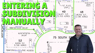
How would you suggest completing the following curve in ArcPro? THENCE SOUTH 03°33'15" EAST 94.04 FEET TO A POINT ON A CURVE TO THE LEFT, THE RADIUS POINT BEING AN IRRIGATION PIVOT WHICH BEARS NORTH 86°26'45" EAST 1318.52 FEET: THENCE EASTERLY ALONG SAID CURVE 4017.93 FEET:
Start a traverse with the S 03-33-15 E; 94.04' line. Then in the next line type in "86-26-45rb" in the direction type-in, the enter 0 in the distance, then enter the radius and arc length, but since it's going left enter a negative (minus) sign in front of the radius.


Fantastic video... I can't believe you don't have more likes!
Thanks!
I appreciate it. Thanks!
Awesome video. Very concise and informative. Would love to see an updated video including the steps to get the bearings to show on the attribute table or just information in the description
Thanks
This video may help: ua-cam.com/video/ClQ8paAZEC8/v-deo.html
Why didn't you separate them into individual lots? You should start at the POB of a lot and return to that POB to finish that lot. Then start the next lot at its POB.
Sure, that would work too and probably easier. Not sure why I started with this particular method.
How would you suggest completing the following curve in ArcPro? THENCE SOUTH 03°33'15" EAST 94.04 FEET TO A POINT ON A CURVE TO THE LEFT, THE
RADIUS POINT BEING AN IRRIGATION PIVOT WHICH BEARS NORTH 86°26'45" EAST 1318.52
FEET:
THENCE EASTERLY ALONG SAID CURVE 4017.93 FEET:
Start a traverse with the S 03-33-15 E; 94.04' line. Then in the next line type in "86-26-45rb" in the direction type-in, the enter 0 in the distance, then enter the radius and arc length, but since it's going left enter a negative (minus) sign in front of the radius.