But they want to tell us that Africa is over-populated. No, all the other nations are. Africa is HUGE and can easily fit another 4 billion people if it wanted to.
Ethiopia alone is as big as France and Spain combine together. On other hand the land space of DRC is so immense that almost all Eastern European countries can fit in.
Africa being the cradle of the human race has had more time to build an advanced civilization than any other place on Earth have they no the only technology they have the only civilization they have comes from white people
And that's why the chinese are coming to take over. The Arabs have already taken up the northern Africa. South Africa too is being over populated by whites and other races from outside africa.
@@jean6030 China is trying to take an advantage of then underdeveloped economy of Africa because their economy is starting to reach is potential and it's growth will decrease by a lot in the coming years. They need badly educated people for labour because their quality of life&education is high (because of their economy reaching its' potential) it's kinda sad really, Africans even think they're helping them in construction projects out of pure heart
@@Mmmm-lx9vb Untill African countries focus on trading between themselves and stand up to fight for one another as a step towards United Africa, africa will remain like fish on a plate to be shared by the other continents.
@@KateeAngel desert is only in the south regions but in the north is defferent place there is snow in the east and in west there is special wether&mountains so many trees and othere search gor more
I live in northern Morocco. This video crushed my dream of bicycling to the coast of South Africa. Oh well I probably would have given up after a couple of hours anyway.
I always knew that countries along the equator were displayed too small and countries close to the poles too large, but when you moved South Africa over Europe, it was really eye opening! Great video with amazing animations! My favorite channel!
Yeah that's how I always saw it. I knew it was stretched and I've seen maps of what it would look like more accurately it never really saw comparisons. With Africa being on the equator it was always much more easily able to accurately size. He mentioned how it was also about geopolitics with it trying to make Europe look good but man seeing China SHRINK is crazy. The size of the countries never bothered me over all since I think shapes, navigation etc are more important than size, size of countries is more of a novelty and for fun but not practical or useful.
There are other maps, maps of Afrika drawn by Ancient Afrikans! Also, the orientation of Afrika is incorrect on these european drawn maps...as ancient Afrikans have south as up and north as down! Good information presented! Thank you!
@@diomedes8791 Because most Afrikan languages do not have a c and for those that do the c sound is pronounced as "ch," and not the "k," sound, as in "Africa." Also, the spelling of Afrika with a "c," in place of the k is european, as their languages have a c with the k sound. Salama
@@5annent yes they turned our history back to front but we have to unlearn what we've learnt.it our time now.. welcome to the new awakening. Sending positive energy and good vibration.
@@dianetigert1310 Leave it to a female to lie that "size has no meaning". lol Tell us WHERE live "the people who make up that nation"? As long as the "people" live on LAND, BOTH the size & shape of that land will always matter: Size will guide us as to how many of "the people" can fit the land efficiently. And "shape" of land will determine the directional, etc advantages or disadvantages of the land. Now, if our "people" live in space, then you may have a point .... in space! lol
@@mekaya456 I don’t really know anybody that cares... I know here in the US, Black Americans are obviously considered a minority but I don’t know of anyone ever thinking or even worrying about global minority or majority populations
.... Who says that Africa is small, or under populated? No, one. In fact a common stereotype of any African is having too many babies. Also, not a single person I know thinks Africa is small by any means.
@Evil Ernest Borgnine You don't have your name for no reason, evil! Then you believe in NDNA wicked Science than the Most High? She is so-called Haitian, and I am, I cannot call myself a brother! First of all: Israel composes in twelve tribes God himself said, Israelis as the stars in heaven, as the sands of the sea.
I’m Sudanese. I live in the UK but annually I go to visit my friends and family back in Sudan. On one trip, we had to travel by bus from Khartoum all the way to Dilling. On a Mercator map it looked like a short distance, but, in reality, it felt like forever. Greetings from Scotland 🏴
The famous Blue Marble photo of the Earth is originally oriented with the South Pole up. That would freaked too many people, so NASA turned it upside down.
Lol our Kruger national Park is the same size as Belgium mind you Kruger national Park is a small section in the northern part of our country .Distance from Cape Town to Musina it's said is the same distance from Greece all the way to the UK namely across the entire continent .
Well yes... The magnetic north pole is near the geographic south pole. Though magnetic poles can flip, so it's not clear if that really counts. However, changing the map to be "upside down" still relays the same information, so there's no issue with doing that.
They make the Continent of Afrika smaller on maps for political and social purposes, to take away the physical impact of the size of the continent of Afrika in comparison to western countries
It's even more big then that they make it smaller cause they know African's ruled all those ancient land's though out the world all the ancient black people was related to each other directly or indirectly
This not surprising to me, schooling in Jamaica tell that Africa is the largest continent on earth but of course over the years things has changed so much by these mzungu who want to erase Gods boundaries,
Some of you people are not very smart. Every map of the world is a compromise due to geometry. Even I learned about various projections of maps back in sixth grade and how each introduced distortions that are impossible to avoid. One just has to be smart enough to understand this and take it into account.
Like you said at the end, I think this is a great reason to make spherical globes more popular - I'd imagine that a globe is the most accurate, as long as its mapped correctly. The main issue is that you can only see one side at a time - but with digital apps its not really a problem.
This was a very good video. Thank you for making one that lays out all the factual reasons for Maps turning out like they do and not just blaming it on racism. A lot of people just don’t seem to understand that a sphere cannot be accurately portrayed on a flat piece of paper, something has to give. I can tell you though as a little white boy growing up in Texas there was always a caveat discussed when looking at those large Maps and being informed about the actual size differences.
As a sailer I am much more concerned about the shape of the coastline, I can't even see the size of the country so it doesn't matter to me at all. An accurate map of the coastline, reefs, islands, sandbars, etc. is the only important thing.
Yes and. Marine and nautical needs are vastly different than the educational needs of public schools anywhere in our world. May we all understand the importance of our oceans and maybe maps could be built around global weather changers such as the Gulf Stream?
That is not France. That is Spain. 08:32 I prefer a map with the real shape. If I have that, and I know that it is in reality smaller, I can easier adjust the size in my head. If I have the wrong shape I can't adjust for that in my head, because I don't know the real shape. Then we could just use circles.
Which map to use? It depends on what you're doing. Mercator's projection was meant for navigation at sea -- you wouldn't want to attempt that with a Gall-Peters projection. Likewise, lessons in geopolitics probably work better on Gall-Peters than Mercator.
Because of the greed and bad business deals of many African leaders. For example, in exchange of letting African students receive a free education in China, many African countries have given China open, unlimited access to gold mines.....insanely bad idea!
They had their "book" and Africa had the land; now Africa has their "new book" with wrong maps and they have the resources!!! The most resourceful continent on the planet has been rendered to being the poorest! Lesson: be simple and innocent but never give away Your culture; You would loose all!
@@onlythetruth883 i wonder how some guys claim to live in developed countries but are ignorant as fuck...just Google what I said and confirm for yourself...and yes we had dhows in east Africa where I come from which were used in trade in the indian ocean with the Omani Arabs before America was even a country
@@onlythetruth883 did you know that Ethiopia was Christian before all Europeans and before the Vatican was built...they have a church that was carved out of a hill in lalibela in the 4th century...the second oldest mosque in the world is also in Somalia and was built during the lifetime of prophet Muhammad
When you grown up with the Mercator projection, the Gall Peters projection is an eye-opener - but I prefer the Winkel Tripel projection, because it is closest to a globus.
All the things they taught us in school are wrong it's high time we found out the truth about ourselves as Africans and then rise up and unite together as one. Actually the bible says the world is not round like they made us believe. Rise up Africa Rise up!!!! I love you Africa!!!
Even knowing that there is this distortion in the maps, I confess that yesterday I was shocked to discover that Accra is more or less the same distance from Fortaleza in Brazil and Barcelona in Spain as from Nairobi.
Shout out to the editor on this video! High quality and intricate visuals. I hope these videos make it to some kind of national African school system programming (United States of Africa).
Before the current maps... Ancient Egyptians credited the North Pole as the source of the nile.. Meaning southafrica and artarctica is north pole... Europe and artic is south pole
@@marquesburman1380 We live on a rock in the middle of complete void. There's no up and down 😐 Just its two magnetic poles and neither are less right than the other
I think nowadays the answer to which projection to use is much easier... You showed it at 0:27 ! Most maps that we see are on screens and not on paper, and a screen has no trouble showing a sphere that you can rotate. I love comparing all the flat projections and what they do to a sphere, but I'm all for just showing the earth as a sphere whenever possible.
4:02 Scale of US is not accurate,landmass of the mainland US is 7.6 million square kilometers,including Alaska and Hawaii it’s more than 9.1 million square kilometers.
Hello Jeannette I thank you very much for your ❤ and your very kind message. I'm from Switzerland but I live now since 2015 in North Africa. 1 hour down from Tunis in a big city at the Ocean. And I'm connected with Africa for now good 30 years. So it interests me of course how and what happen here. Like under Africa is a new Ocean and a part in the east will drift away from the "big Africa". Then is a big and a smaller Africa and between an Ocean. I would give this ocean between the name "EAST AFRICA OCEAN" !!!! I wish you and the whole team a very wonderful day. Martha ❤❤❤🏝🏝🏝🌊🌊🌊🌊🐬🌊🌊🏖👋🥰💘💘💘💘🌴🐚🌴
Please tell I was not the only one who knew how big Africa was🤨geography was boring but I did stay awake for that. Maybe it was drawn to fit the paper😳teacher why only one piece of paper for a big place.. budget allows for only one.. wish I made that up
JANA burke You are definitely not alone. I also realized how BIG Africa is. Always making reference to it as the biggest and the bestest with all resources. So for all that; I am constantly amazed that they sold themselves as slaves. And till today still wonder exactly why they did that. Still remains an actual mystery for me.
Very interesting news about Africa. GREAT VIDEO and good to know how big is Africa really. Thanks for your informations. Martha 👍💥💥💥💥💥🌴❤❤❤🍃🌏🌵🐚🌊🌊🌊🌊🌊🌊🐬🐠🌊🌊🐠🌊🌊🐳🏝🌿🌴🌏🥰
They colonised everything and made sure that we learn it from a young age it's solidified the notion that Africa is smaller than Europe Asia America etc they made us feel small that way
Great video and point about converting a sphere to a flat surface. However, I don't see the point of comparing the size of a continent to the size of states and countries.
It's not inaccurate. That particular projection ( called the Mercator projection ) has a purpose. It makes straight line navigation while sailing possible. Since early maps were only created to serve a particular purpose and circumnavigating the globe was incredibly important the majority of maps printed for many many hundreds of years use some form of the mercator projection. Printing maps was expensive and time consuming so they didn't really make world maps for other purposes. It is not correct to say that the Mercator projection is inaccurate. It is a fair point to make that most people are unaware of the fact that that version of a world map does not serve the purpose to give you relative size and position of continents.
The Mercator projection is much reliable for navigation, as it doesn't distort the shape of the continent, and maps are mostly used for navigation rather than finding the size of a certain place.
Germany is about 1.6 times smaller than Kenya. Kenya is approximately 580,367 sq km, whileGermany is approximately 357,022 sq km, making Germany 61.52% the size of Kenya. Meanwhile, the population of Kenya is ~53.5 million people (26.6 million more people live inGermany).
I'm really happy to see this. Its about time for Africans to unveil their own stories and discoveries. Keep it up bro! I like what you're doing. I've always said this to myself, the map isn't accurate but a complete work of perception.
Gall-Peters was never going to be an effective replacement for Mercator. Any concerns about the subtle psychological implications of imperialist subtexts from Mercator are subsumed by the fact that Mercator is really good at what maps are primarily used for: navigation. By preserving shape and therefore angles, Mercator is highly effective in use for navigation, as you said at the end of the video. There are some good compromise maps, most notably the Robinson map, but imo for the purpose of identifying a geographic area and being able to use that information to navigate, Gall-Peters falls short of anything aside from a novelty map


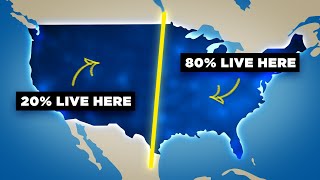


But they want to tell us that Africa is over-populated. No, all the other nations are. Africa is HUGE and can easily fit another 4 billion people if it wanted to.
I've been saying! We don't even have as much people as China or India and we are LARGER than both India and China and still we over populated 🙄🙄🙄
Good point @C. Lincoln
Me too @Kholofelo
Not only 4billion even the whole world population can fit in
@@mupenzirobzy6643 the whole word cat fit inside LA
Ethiopia alone is as big as France and Spain combine together. On other hand the land space of DRC is so immense that almost all Eastern European countries can fit in.
How do I get a real map?
@@davidelba6676 Northern Africa is Arab not black
North Africa is kement n it's for Nubians not Arabs those u see their are Syrians who fought blacks from their land ok.
@alejandro matas truth is bitter on us but we stole alot from blacks even Monaco belongs to them go check hidden history.
That's what you know but hidden history shows those Arabs their came from Syria and that part belongs to melanin whom you call black
Knowledge is power. Now it's time to stick together and save the continent from complete dominancy of other nations. Bigger is abundance!!!
They don't allow us to do that😞
Shut up amrikan
Tell me one person who believed Africa was small?
@@vve2059 .... That's not a argument.
I know that game
Love from India, 🇮🇳♥ Africa 🌍
Africa being the cradle of the human race has had more time to build an advanced civilization than any other place on Earth have they no the only technology they have the only civilization they have comes from white people
@@thehillbillygamer2183 no
@@Zdfzrfdsfj He's been indoctrinated by the whitewash Europe system.
did u know that India was once connected to Africa? the weather patterns are the same so are many animals
Thanksk from Zambia 🇿🇲❤️
I keep praying Africans realize the fact that we are naturally blessed in All angle
And should appreciate it
How you going to appreciate it when the European hayenas are constantly circling
And that's why the chinese are coming to take over. The Arabs have already taken up the northern Africa. South Africa too is being over populated by whites and other races from outside africa.
@@jean6030 China is trying to take an advantage of then underdeveloped economy of Africa because their economy is starting to reach is potential and it's growth will decrease by a lot in the coming years. They need badly educated people for labour because their quality of life&education is high (because of their economy reaching its' potential) it's kinda sad really, Africans even think they're helping them in construction projects out of pure heart
Dividing them into 54 countries ensured a lack of unity. Imagine a united Africa under one government.
@@Mmmm-lx9vb Untill African countries focus on trading between themselves and stand up to fight for one another as a step towards United Africa, africa will remain like fish on a plate to be shared by the other continents.
The positioning of Madagascar over the US is really an eye opener! Very educative content, Risen Africa
Very 👁 opening
Very fascinating and informative information sir. Africa unit! Much love from South Africa 🇿🇦
It's why I really love having a physical globe instead of a map on the wall
Concur. I keep cheap blow up globes to discuss with children any geography concepts.
Even better if it's big enough to mount on wheels and hide a drinks cabinet inside!!
Africa Unite, Peace. Thank you for your channel.
God! I love your accent sir!!!
Love from Nigeria!
Thank you! 😃
Drop ia, and the name needs to change.
@@igkslife Niger and Nigeria are centered on the Niger River. Go take a hike. I'm black and know that that name is fine.
@@tt_sallie thank you very much . Not people trying to make everything about race 🤦🏾♀️
@@igkslife u r correct. name given to area (niger+area) by the colonizers.
I live in Algeria, and it's a never ending land.
Never ending desert?
@@KateeAngel I haven't even been able to visit the desert and rocky areas yet, I heard it's beautiful.
@@KateeAngel desert is only in the south regions but in the north is defferent place there is snow in the east and in west there is special wether&mountains so many trees and othere search gor more
@@KateeAngel wow, you think Algeria is just desert, another distortion of fact,
@@alaagoni8227 the vast majority of Algeria is desert.
I love the way everyone is saying something nice followed by their country.
😂🇰🇪Kenya
Kenya here in the house
Hey brother from KE.
I live in northern Morocco. This video crushed my dream of bicycling to the coast of South Africa. Oh well I probably would have given up after a couple of hours anyway.
@Leonard Weisfeld but don't go in winter, if you slip it's a long fall!
I guess I'm the only one who notice he was joking? 🤔
😂😂😂
😂😂😂
Your clarity and illustration is impeccable...
I always knew that countries along the equator were displayed too small and countries close to the poles too large, but when you moved South Africa over Europe, it was really eye opening! Great video with amazing animations! My favorite channel!
Much appreciated @Sven Markert.. I'm glad you enjoyed as well as got some value.. Many thanks for watching and for the support
Yeah that's how I always saw it. I knew it was stretched and I've seen maps of what it would look like more accurately it never really saw comparisons. With Africa being on the equator it was always much more easily able to accurately size. He mentioned how it was also about geopolitics with it trying to make Europe look good but man seeing China SHRINK is crazy. The size of the countries never bothered me over all since I think shapes, navigation etc are more important than size, size of countries is more of a novelty and for fun but not practical or useful.
Great Vid, should be shown in classrooms! Cheers from Australia!
May god protect Africa🙏🙏❤❤
God not god
I wish African will kick outsiders ass from Africa permanently. Best of luck.
@@pascala3823 you gonna cry?
@@Wongphee They were just being technical, so leave them be.
Jesus is the risen king he is always our guide
Great content brother! I hope your channel grows bigger to your wish as it has great knowledge facts. Kudos ❤️ Love from Uganda 🇺🇬
Much appreciated @Osman M
@@RisenAfrica ...except for the race hustling aspect.
There are other maps, maps of Afrika drawn by Ancient Afrikans! Also, the orientation of Afrika is incorrect on these european drawn maps...as ancient Afrikans have south as up and north as down! Good information presented! Thank you!
Glad you enjoyed it @leo
That’s very interesting. Could please share a source where I can find those maps? Thanks in advance!
@@MyVoiceThyWord yes please!!! I really would like to see it too.
Why do you spell Africa with a K?
@@diomedes8791 Because most Afrikan languages do not have a c and for those that do the c sound is pronounced as "ch," and not the "k," sound, as in "Africa." Also, the spelling of Afrika with a "c," in place of the k is european, as their languages have a c with the k sound. Salama
Love how you animate your videos! Greetings from Germany!!!
Thank you very much! Glad you enjoyed them
🙌🏾I wanna work with you fam. Lemme know if you need Logo design, cover art, cartoon pic, flyers, UA-cam intros and much more
@021 Sister...smh...
Very informative. All the this while i thought Africa was small. This is so amazing
I never thought Africa was small.
Why would u think that.. when the majority of us knows that Africa is the biggest continent in the world
@@arielrose8420 ) in school they always told us Africa was the Second largest continent!) While asia was the first largest continent?)
@@5annent yes they turned our history back to front but we have to unlearn what we've learnt.it our time now.. welcome to the new awakening. Sending positive energy and good vibration.
My country is small on all maps. Love from the Netherlands
Thats true @Jannette! Many thanks for watching
Your country is consumed by the ocean
Me too
Maar jou mense is laank
@Jeanette Berends: My country Belgium is even smaller than your country 🤣
Facts i always think about this africa is bigger than it appears
You're right @Ebrima Tunkara.. Thanks for watching
@@dianetigert1310
Leave it to a female to lie that "size has no meaning". lol
Tell us WHERE live "the people who make up that nation"?
As long as the "people" live on LAND, BOTH the size & shape of that land will always matter: Size will guide us as to how many of "the people" can fit the land efficiently.
And "shape" of land will determine the directional, etc advantages or disadvantages of the land.
Now, if our "people" live in space, then you may have a point .... in space! lol
@@dianetigert1310
Bet you are an expert with your mouth "closed"/full .... or whatever, Ms "size doesn't matter"? lol
Suspect the same tactic is used when they refer to African population
100%!
💯 some say its closer to 4 billion. I believe it. But they dont want us to know that we are actually the majority. Facts!
@@mekaya456 I don’t really know anybody that cares... I know here in the US, Black Americans are obviously considered a minority but I don’t know of anyone ever thinking or even worrying about global minority or majority populations
.... Who says that Africa is small, or under populated? No, one. In fact a common stereotype of any African is having too many babies.
Also, not a single person I know thinks Africa is small by any means.
@@caphusnho ... So you discovered the best way to flatten a glob? In a way that is mathematically correct? Show me.
Haitian waving from Canada! XO
Thanks for watching @Chapman Collects
Your brother waves from Maryland.
@Evil Ernest Borgnine You don't have your name for no reason, evil! Then you believe in NDNA wicked Science than the Most High? She is so-called Haitian, and I am, I cannot call myself a brother! First of all: Israel composes in twelve tribes God himself said, Israelis as the stars in heaven, as the sands of the sea.
Interesting and informative appreciate this work, coming from the UK always thought the maps were distorted but hadn't seen it explained before 😀
Thank you! Appreciate the initiative and information.
I'm even leaning toward the flat earth rather than a globe. Seems to make much more sense.
I’m Sudanese. I live in the UK but annually I go to visit my friends and family back in Sudan. On one trip, we had to travel by bus from Khartoum all the way to Dilling. On a Mercator map it looked like a short distance, but, in reality, it felt like forever. Greetings from Scotland 🏴
Which Sudan?
@@shangothunder1055 he said that he visited Sudan not South Sudan, another clue ( Khartoum ) so it is obvious.
Wowww! Great information. I love the break down.
Let’s make our own map 💅🏽. Also turn the map upside down the correct way 🇬🇲
You are woke sister
The famous Blue Marble photo of the Earth is originally oriented with the South Pole up. That would freaked too many people, so NASA turned it upside down.
So I guess the needle of a compass points north because it is racist.
@@danbowman9294 No, but there is a perception that top is better than bottom.
Nini nothing to stop you. Go on do it.
Lol our Kruger national Park is the same size as Belgium mind you Kruger national Park is a small section in the northern part of our country .Distance from Cape Town to Musina it's said is the same distance from Greece all the way to the UK namely across the entire continent .
korrection,,,
DISTANCE FROM GREECE TO UK IS 3 500 KMs
Distance from Cape Town to Musina is 1 900 kms
but i get your Point, Africa is HUGE!
brother you forgot to tell us the map is upside down, this is a fact from ancient maps.
???
So basically the real world is like Attack on Titan.
Expect in space
Sides are relative
Rofl
Well yes... The magnetic north pole is near the geographic south pole. Though magnetic poles can flip, so it's not clear if that really counts. However, changing the map to be "upside down" still relays the same information, so there's no issue with doing that.
Yep. Australia n Africa is closer to the sun than any other country...
They make the Continent of Afrika smaller on maps for political and social purposes, to take away the physical impact of the size of the continent of Afrika in comparison to western countries
It's even more big then that they make it smaller cause they know African's ruled all those ancient land's though out the world all the ancient black people was related to each other directly or indirectly
This not surprising to me, schooling in Jamaica tell that Africa is the largest continent on earth but of course over the years things has changed so much by these mzungu who want to erase Gods boundaries,
Good point @Abdul Many thanks for watching
Some of you people are not very smart. Every map of the world is a compromise due to geometry. Even I learned about various projections of maps back in sixth grade and how each introduced distortions that are impossible to avoid. One just has to be smart enough to understand this and take it into account.
They?
Thanks a lot for this, love from Liberia 🇱🇷🇱🇷🇱🇷
Like you said at the end, I think this is a great reason to make spherical globes more popular - I'd imagine that a globe is the most accurate, as long as its mapped correctly. The main issue is that you can only see one side at a time - but with digital apps its not really a problem.
Amazingly educational video. Good job!
@Evil Ernest Borgnine Are you saying your elementary school is better than mine?
@Evil Ernest Borgnine Actually, I think I got really good geography classes. But somehow this one on Africa slipped through the cracks, I suppose.
Always on tym
Thanks bro
Great content always
💕💕💕
Keep it up
Thank you so much 😀.. Glad you're watching @luffy d shafique
This was a very good video. Thank you for making one that lays out all the factual reasons for Maps turning out like they do and not just blaming it on racism. A lot of people just don’t seem to understand that a sphere cannot be accurately portrayed on a flat piece of paper, something has to give. I can tell you though as a little white boy growing up in Texas there was always a caveat discussed when looking at those large Maps and being informed about the actual size differences.
Many thanks @Jeff.. Means a lot. Glad you enjoyed it.
Exactly @Marchbaby.. Not everything should be blamed on racism, much appreciated
This is an awesome video! Thank you so much!
I personally like the Sinu-Mollweide map projection. It show the real size of countries, plus it shows almost accurate shapes.
True, DRC is a gargantuan country.
I knew all this but Madagascar shocked me 😱
As a sailer I am much more concerned about the shape of the coastline, I can't even see the size of the country so it doesn't matter to me at all.
An accurate map of the coastline, reefs, islands, sandbars, etc. is the only important thing.
Yes and. Marine and nautical needs are vastly different than the educational needs of public schools anywhere in our world. May we all understand the importance of our oceans and maybe maps could be built around global weather changers such as the Gulf Stream?
If it doesnt matter to you white people. Then why hide the actual size of it. White supremacist always defending bullcrap
Thanks. Very informative
uko na content poa manze n ur so eloquent, hii channel itagrow sana
I remember getting a talking globe as a child and being fascinated 🗣Bring globes back!!
Globes are racist
@@ZackWolfMusiclol
Thank you very much sir. Your videos make me understand Africa even better.
Writing from Cameroon
Surprisingly good video.
Superb video, the only problem were the adverts that were six times bigger than the actual video...
i love how when I imedietly finished watching this the original version played next made 4 years ago
Fly from cape town to London about 12+ hours flight .it takes 11 hours to get to the Mediterranean sea
True.. A testament to the real enormity of Africa
That is not France. That is Spain. 08:32
I prefer a map with the real shape. If I have that, and I know that it is in reality smaller, I can easier adjust the size in my head. If I have the wrong shape I can't adjust for that in my head, because I don't know the real shape. Then we could just use circles.
The rest of the world does not want to admit that Africa is a beautiful large continent.long live Africa.
Which map to use? It depends on what you're doing. Mercator's projection was meant for navigation at sea -- you wouldn't want to attempt that with a Gall-Peters projection. Likewise, lessons in geopolitics probably work better on Gall-Peters than Mercator.
Waw how is this possible as small as France is they are able to do so many damage to the continent of Africa 🌍
They just happened to be technically better at the time because they had tanks, guns and big gun ships. We just couldn't repell their advances.
Helped
Because they keep Africa divided. We must have a United States of Africa!
Because of the greed and bad business deals of many African leaders. For example, in exchange of letting African students receive a free education in China, many African countries have given China open, unlimited access to gold mines.....insanely bad idea!
@@shanchan8247 it's truly sad 😥😞 our generation are going to struggle big time do to our greed and selfish ways
Do you have any info about the earlier maps of Africa and the names of places as they were called ?
1747 Bowman's Map of Africa will help
@@yawanim2436 Thanks.
I've never watched anything about Africa that's not focused on South Africa and be so interested before. Great job bro, really nice content 👍✊
Yap very stupid & Adamant.
They had their "book" and Africa had the land; now Africa has their "new book" with wrong maps and they have the resources!!! The most resourceful continent on the planet has been rendered to being the poorest! Lesson: be simple and innocent but never give away Your culture; You would loose all!
Africans had books before Europeans...Timbuktu had a learning institution and library in the 15th century
@@Brian-bo4bz
I think you also had ships before Europeans.
It's just that you left them parked in non existent shipyards.
@@onlythetruth883 i wonder how some guys claim to live in developed countries but are ignorant as fuck...just Google what I said and confirm for yourself...and yes we had dhows in east Africa where I come from which were used in trade in the indian ocean with the Omani Arabs before America was even a country
@@onlythetruth883 did you know that Ethiopia was Christian before all Europeans and before the Vatican was built...they have a church that was carved out of a hill in lalibela in the 4th century...the second oldest mosque in the world is also in Somalia and was built during the lifetime of prophet Muhammad
@@onlythetruth883 Timbuktu is not an imaginary place just Google it unless you enjoy living in ignorance
This is the best reason why the Internet is great. We learn things that others try to hide to obscure the truth.
Means a lot you saying this @Pessa007.. Many thanks for watching, cheers!
Once again, a masterclass in narration.
When you grown up with the Mercator projection, the Gall Peters projection is an eye-opener - but I prefer the Winkel Tripel projection, because it is closest to a globus.
Good day. To me size is major concern than shape
Its weird this video compares the whole continent of Africa to the size of countries instead of other continents.
All the things they taught us in school are wrong it's high time we found out the truth about ourselves as Africans and then rise up and unite together as one. Actually the bible says the world is not round like they made us believe. Rise up Africa Rise up!!!! I love you Africa!!!
This is some good work bro. Very impressive. Knowledge is Power
That map is still wrong. That part where Saudi Arabia is, is part of Africa it self.
Damnnn thank you. Now I understand why !!! 😲😲
Glad it was helpful
Even knowing that there is this distortion in the maps, I confess that yesterday I was shocked to discover that Accra is more or less the same distance from Fortaleza in Brazil and Barcelona in Spain as from Nairobi.
Wow! Indeed Africa is huge
Yes the oceans are vast
Shout out to the editor on this video! High quality and intricate visuals. I hope these videos make it to some kind of national African school system programming (United States of Africa).
Before the current maps... Ancient Egyptians credited the North Pole as the source of the nile.. Meaning southafrica and artarctica is north pole... Europe and artic is south pole
The map is upside down
@@marquesburman1380 yes in simple terms 😊
@@marquesburman1380
We live on a rock in the middle of complete void. There's no up and down 😐 Just its two magnetic poles and neither are less right than the other
Many thanks for this facts. Well done.
Size is important compared to shape
Thnks
I think nowadays the answer to which projection to use is much easier... You showed it at 0:27 ! Most maps that we see are on screens and not on paper, and a screen has no trouble showing a sphere that you can rotate. I love comparing all the flat projections and what they do to a sphere, but I'm all for just showing the earth as a sphere whenever possible.
Makes sense @Mow.. Many thanks for watching
@@RisenAfrica Thank you for your amazing videos!!
First! Great video
Sure
Legend! Many thanks @Lauren! Glad you're watching
4:02 Scale of US is not accurate,landmass of the mainland US is 7.6 million square kilometers,including Alaska and Hawaii it’s more than 9.1 million square kilometers.
All scales of countries are wrong
Hello Jeannette
I thank you very much for your ❤ and your very kind message.
I'm from Switzerland but I live now since 2015 in North Africa. 1 hour down from Tunis in a big city at the Ocean. And I'm connected with Africa for now good 30 years. So it interests me of course how and what happen here. Like under Africa is a new Ocean and a part in the east will drift away from the "big Africa". Then is a big and a smaller Africa and between an Ocean. I would give this ocean between the name "EAST AFRICA OCEAN" !!!!
I wish you and the whole team a very wonderful day.
Martha
❤❤❤🏝🏝🏝🌊🌊🌊🌊🐬🌊🌊🏖👋🥰💘💘💘💘🌴🐚🌴
It will never work because you can’t put something relatively flat on something round with out distorting it.
I think it would be good to teach with both maps, with lessons on what each is good for
I recall this information being taught in the 1960's. Guess it needs to be re-taught.
Let's not forget the point in the video that there's really no good way to make a flat map of a round world.
Earth is flat
Exactly
You are very underrated. The quality of your content is amazing, great job 👏 🤩 I subbed because I love your videos
use a flatearth map, will solve the problem.
For geopolitical purposes, it is better to distort the shape. For travel, it is better to distort the size.
what program or website are you using to slide countries over on the map to show relative size? I want to use it as well.
I used a website called the truesizeof.com. Have fun with it, it helped a great deal
@@RisenAfrica thank you, I will! and thank you for the videos, I love your channel!
Please tell I was not the only one who knew how big Africa was🤨geography was boring but I did stay awake for that. Maybe it was drawn to fit the paper😳teacher why only one piece of paper for a big place.. budget allows for only one.. wish I made that up
JANA burke
You are definitely not alone.
I also realized how BIG Africa is. Always making reference to it as the biggest and the bestest with all resources.
So for all that; I am constantly amazed that they sold themselves as slaves. And till today still wonder exactly why they did that. Still remains an actual mystery for me.
Very interesting news about Africa. GREAT VIDEO and good to know how big is Africa really.
Thanks for your informations.
Martha
👍💥💥💥💥💥🌴❤❤❤🍃🌏🌵🐚🌊🌊🌊🌊🌊🌊🐬🐠🌊🌊🐠🌊🌊🐳🏝🌿🌴🌏🥰
Glad you enjoyed it and also got value @Martha.. Thanks for watching
They colonised everything and made sure that we learn it from a young age it's solidified the notion that Africa is smaller than Europe Asia America etc they made us feel small that way
Exactly
Russia and USA that are powerful nations were drawn to be so much large in size
Why are you people so deluded.
They weren't. Just your mind tricking you.
Great video and point about converting a sphere to a flat surface. However, I don't see the point of comparing the size of a continent to the size of states and countries.
last time i was surprised to know that my country Cameroon is far bigger than Germany.
Really. Everybody knows the size of countries. Was your schooling inadequate to teach you that Cameroon is bigger than Germany?
8:30
I am sorry, but instead of France, you showed Spain instead.😆
Great work on your video though.👍
Nice job ✊🏿✊🏾✊🏽
Many thanks @Skeza, glad you enjoyed
Surprisingly your voice is nice to listen to
It's not inaccurate. That particular projection ( called the Mercator projection ) has a purpose. It makes straight line navigation while sailing possible. Since early maps were only created to serve a particular purpose and circumnavigating the globe was incredibly important the majority of maps printed for many many hundreds of years use some form of the mercator projection. Printing maps was expensive and time consuming so they didn't really make world maps for other purposes.
It is not correct to say that the Mercator projection is inaccurate. It is a fair point to make that most people are unaware of the fact that that version of a world map does not serve the purpose to give you relative size and position of continents.
Dwarfing Africa on the map was to just screw up our self esteem
Oh please.
The Mercator projection is much reliable for navigation, as it doesn't distort the shape of the continent, and maps are mostly used for navigation rather than finding the size of a certain place.
Africa is massive...
Germany is about 1.6 times smaller than Kenya.
Kenya is approximately 580,367 sq km, whileGermany is approximately 357,022 sq km, making Germany 61.52% the size of Kenya. Meanwhile, the population of Kenya is ~53.5 million people (26.6 million more people live inGermany).
Yet these are the same fools calling Africa overpopulated
I'm really happy to see this. Its about time for Africans to unveil their own stories and discoveries. Keep it up bro! I like what you're doing. I've always said this to myself, the map isn't accurate but a complete work of perception.
Glad you enjoyed it @Paul Okeke, will keep at it, More to come!
Gall-Peters was never going to be an effective replacement for Mercator. Any concerns about the subtle psychological implications of imperialist subtexts from Mercator are subsumed by the fact that Mercator is really good at what maps are primarily used for: navigation. By preserving shape and therefore angles, Mercator is highly effective in use for navigation, as you said at the end of the video. There are some good compromise maps, most notably the Robinson map, but imo for the purpose of identifying a geographic area and being able to use that information to navigate, Gall-Peters falls short of anything aside from a novelty map