Many countries are cursed by this projection. For example, when you look at Germany it looks close to the size of Turkey but in reality, Turkey is almost twice the size of Germany. Also, Europe seems a little stretched out and different from its real form. There are many misrepresentations of reality that people don't really notice but Russia and Greenland are just on the levels of absurdity.
True, but you would need the Azimuthal map to know which direction to drill, and some 'math' to figure out what angle so you pop back out in the desired spot.
Reminds me of when my 2nd grade teacher (the penguin fanatic) taught us that Antarctica was the largest continent. I don’t recall a globe in her classroom.
I wasn't taught it, but when I was in second grade, I thought Antarctica was the largest continent because of how distorted it is on a rectangular map and how it being nearly invisible on the bottom of globbes that only turn on the Earth's axis of rotation(I was older by the time I encountered a globe that could tilt to give a better look at the shouthern hemisphere.
I feel like Zach got annoyed at a flat-earther and decided, probably after a breathing exercise or two, to be the adult in the room and break it down instead of just call the person an idiot..
7:04 Measuring the angles of celestial bodies relative to the horizon predated the sextant by many centuries. Most used the principle of a weighted pointer moving against a curved protractor-style scale, though a device called a cross-staff relied on perspective instead, which helped to nullify the effects of the ship's rolling motion.
@@mikefochtman7164 "Several" undersells it! Geoffrey Chaucer, in addition to _The Canterbury Tales_ wrote an instruction manual explaining nearly 50 uses of the classic astrolabe (note though that the sailor's astrolabe tended to be simpler than that, optimised for the functions useful in navigation)
There is no North Pole in the Mercator projection as it would be infinitely far away. It has to be cut at some point. Once you go fair enough a single snow flake will cover the entire width. Typically it is cut so that only the tip of the Greenland is shown.
3:15 actually any azimuthal projection would give you the answer but I would choose the gnomonic projection instead of the azimuthal equidistant bc the gnomonic projection projects ALL great circles as straight lines so you're not limited to Lisbon or Washington DC as the center point. You can choose any point for the center point as long as both Lisbon and Washington DC are on the map and you would be able to find the shortest route between them
@@2bfrank657it can only show at most the half of the earth (showing exactly half requires infinite surface area) also the distortion becomes real bad at the edges
8:17 - Error. The top and bottom of a regular Mercator projection map _cannot possibly_ be the North or South pole, because in that projection, the poles project to infinity.
To add a bit more context: A true mercator projection would stretch infinitely in both vertical directions, so most maps that use that projection are usually cut off at some latitudes. The map he's showing is most likely a webmercator projection, where these these latitudes are picked to make the whole thing a perfect square (I think it also assumes the earth is a perfect sphere)
It's such a trip hearing Zach make a serious video, it's like you're waiting for the punchline that never comes.. But that said, these are really interesting videos, although I feel like I know less about maps now, than before I started the video! Or maybe it's just that I realise now how much I _didn't_ know.
7:20 my eyes literally went as wide as they can go. It's always fun when you *think* you know a fair amount about a certain topic, just nod along to the video and then bam, things are put in a context you didn't know was there
A correction about the North and South Poles on the Mercator map. They're not just reduced to single points; they're also (because of the yhdistortion) infinitely far away. You drew the North Pole as if it were at only a finite y-coordinate, so the diagonal rhumb line eventually hits it. But actually, it's infinitely far away so that the rhumb line will go around and around infinitely many times before hitting it. That's why rhumb lines don't just reach the poles; they spiral into the poles, going around them infinally many times before hitting.
Oh. My god. This just finally explained Eulerian vs Quaternian rotation to my brain! xD In Eulerian, you would rotate about the axis connecting the poles, which gives the lines of latitude. But if you actually wanted to take a straight route, which quaternions are great for, it’d be different from that line, as the axis of rotation isn’t the rotational axis of earth but rather the normal to the two points you want to travel between!
The reason why most mapping softwares use the Mercator projection is because Mercator is the only projection that preserves angles and has consistent compass directions (Note: viewing a globe on a 2D screen results in a central perspective projection)
Correction: The north and south poles are not where you showed them on the map, but infinitely far up and down. This follows from the equation provided.
There was a post on insta (yes ik tha hellhole) abt this being disingenuous abt maps and saying 'they are lying to you' (which we all know is wrong, they don't lie. All they do is teach thus in schools so if you don't know this then that's on you) anyway one of the comments was someone complaining that 'why is it all first world countries that have been enlarged' and in her replies complaining abt how racist it was. They just didn't want to understand that the enlarging of countries is purely related to location😂
Thank you so much for the video, i am going to wait a lot for the math explanation, i studied geography at university but i want to improve on my math skills and you have been my favorite youtuber on the area since i met your channel, please keep doing great videos
I thought this video was going to be Yet-Another-YT-Video-About™ map projections and how they're all inaccurate. I was pleasantly surprised that this video was actually something more than the usual and had a novel and interesting take on the concept that actually grabs your attention and makes you think. 👍
You should remember, that Magnetic Pole(compass) is not the same as Geographical Pole(pole on map). Not only it's not the same, but also magnetic field is constantly changing it's position(you can find it's route for the past centuries online). That's why all modern compasses in planes and ships are gyroscopic and require electricity. So, you should take it into account when planning very long routes(if going to use magnetic compass) for thousands of kilometres and make appropriate corrections. That is why old sailors vere relying on stars more then on compass.
While ships use gyrocompasses, most small planes do not. They have a 'heading indicator' that uses a gyroscope, but is not itself 'north-seeking'. It has to be reset by the pilot about every 15 minutes based on the magnetic compass also in the cockpit. Courses on flight nav maps and the headings painted on the ends of runways are in megnetic heading.
i really like the triptychial projection by Björn Grieger but since i'm doing my boating license i gotta use the merkator plotting a course and measuring distances is pretty easy
Weirdly enough, I heard the word earlier today for the first time, when my quantum physics teacher used it as an example of how SU(2) and spinors were commonly known and used, even if not in the same way we know them today, way before quantum physics or even lie theory was well known. The sextant was his example of how this representation of the rotation group was used by engineers all the way back in the 1700s.
Not azimuthal equidistant to find a true great circle path, because that would show the equator isn't a great circle. Instead, think of one where the equator isn't on the map, but at infinity. The gnomonic projection is the one you have to use.
Is there any relationship between this matter and the notions of Ricci tensor and other matters related? If yes, is there any chance to explore this relationship in another video?? 4:48
Kind of? You can calculate the Ricci tensor components for any coordinates, such as the ones on these maps. I recommend this video/the series it belongs to: ua-cam.com/video/ZhDNijOEw0Y/v-deo.htmlsi=xxtAhU0gwHbvoiz0
@@edudmodnar4661if we’re being “umm actually” here might as well bring up that while it’s not a perfect sphere the deviations are so minor that anything the size of globe would have deviations that would be essentially imperceptible
@@edudmodnar4661If the earth were the size of a basketball (using the maximum size of a FIBA men's basketball), the equatorial radius would would be 0.4mm longer than the polar radius. Yes, the earth is technically an oblate spheroid, but it is extremely spherical. It is close enough to a sphere that, unless you are doing some very specific things, you can safely assume it is a sphere.
I keep expecting a flat earth joke. Like Zach is trying to explain non-euclidian geometry to a flat earther. Actually, similar to how you did the invention of numbers, you should definitely do a skit where a non-euclidean geometrist (if that's a word) is trying to explain is worldview (pun intended) to an euclidean geometrist.
The way Zach speaks, you constantly think he is trying to be sarcastic or mocking something, and the joke is just about to be delivered in a moment... You have to keep reminding yourself, that this is not the channel where he makes fun of stuff
Once I have heard the reason why we use this technique is because it makes Africa look small, so the starvation there is underestimated. Feels like a conspiracy theory but idk
Not really. The map was adopted because of navigational benefits. Why it became the default map for all purposes is a bit hazier. It's use as a maritime navigational map (the predominant use of a world map back in the day) is likely a major reason. And its generally maintaining the shapes of countries is useful in an educational environment. At the same time, it making Europe larger was likely a significant factor in its popularity. Not necessarily from any desire for Africa to be small, but it simply made it easier to see European countries and such on a map in a Eurocentric Western World.
Remember what he said about flight times? We know the distances on a flat earther's map do not line up with real flights, which work out when plotted on a globe


I straight up forgot zach can and will make serious videos sometimes
Only when he's willing and able to ayha ;D
He is able and willing to do serious videos
Darn, can’t believe I missed that
He's able and willing to make serious videos
Just when hes not "himself". 💹😂
Thanks to Zach for being Able and Willing to make these videos.
And for being able and willing to understand map projections
It might be difficult for a sailor to stay on the Rhumb Line when it's rum time.
As of writing your comment has 69 likes
@@furnaceheadgames9001 Nice 👍
Aaaarghh
I can still hear the sarcasm in zach's voice even in a serious video
"constantly changing"
Mercator’s projection of Greenland and Russia is so cursed
Many countries are cursed by this projection. For example, when you look at Germany it looks close to the size of Turkey but in reality, Turkey is almost twice the size of Germany. Also, Europe seems a little stretched out and different from its real form. There are many misrepresentations of reality that people don't really notice but Russia and Greenland are just on the levels of absurdity.
And Canada amd Alaska
Antarctica especially
All I learned is that if I want to navigate anywhere I should just fly to Lisbon first
That's what the pros do
Embodiment of the quote "The map is not the territory."
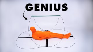
The best way to go straight from point a to point b is to drill sideways through the ground
True, but you would need the Azimuthal map to know which direction to drill, and some 'math' to figure out what angle so you pop back out in the desired spot.
Might as well just appear at point b upon waiting no time because it’s more efficient.
Reminds me of when my 2nd grade teacher (the penguin fanatic) taught us that Antarctica was the largest continent. I don’t recall a globe in her classroom.
I wasn't taught it, but when I was in second grade, I thought Antarctica was the largest continent because of how distorted it is on a rectangular map and how it being nearly invisible on the bottom of globbes that only turn on the Earth's axis of rotation(I was older by the time I encountered a globe that could tilt to give a better look at the shouthern hemisphere.
I feel like Zach got annoyed at a flat-earther and decided, probably after a breathing exercise or two, to be the adult in the room and break it down instead of just call the person an idiot..
A much more mature response than most round-earthers, and that is why I love Zach Star much more than other youtubers.
7:04 Measuring the angles of celestial bodies relative to the horizon predated the sextant by many centuries. Most used the principle of a weighted pointer moving against a curved protractor-style scale, though a device called a cross-staff relied on perspective instead, which helped to nullify the effects of the ship's rolling motion.
And the astrolabe. Measures altitudes similar to a cross-staff, but included several other useful features beyond just angle measurement.
@@mikefochtman7164 "Several" undersells it! Geoffrey Chaucer, in addition to _The Canterbury Tales_ wrote an instruction manual explaining nearly 50 uses of the classic astrolabe (note though that the sailor's astrolabe tended to be simpler than that, optimised for the functions useful in navigation)
There is no North Pole in the Mercator projection as it would be infinitely far away. It has to be cut at some point. Once you go fair enough a single snow flake will cover the entire width. Typically it is cut so that only the tip of the Greenland is shown.
3:15 actually any azimuthal projection would give you the answer but I would choose the gnomonic projection instead of the azimuthal equidistant bc the gnomonic projection projects ALL great circles as straight lines so you're not limited to Lisbon or Washington DC as the center point. You can choose any point for the center point as long as both Lisbon and Washington DC are on the map and you would be able to find the shortest route between them
Interesting. What gets lost if you make such a change of projection? What is the downside?
@@2bfrank657it can only show at most the half of the earth (showing exactly half requires infinite surface area) also the distortion becomes real bad at the edges
I can't wait for the Zach Star Himself video about flat earthers who just can't read a map during a roadtrip.
Finally a new Map Men video!
I love that Zack is both willing and able to make serious videos sometimes
Haha
8:17 - Error. The top and bottom of a regular Mercator projection map _cannot possibly_ be the North or South pole, because in that projection, the poles project to infinity.
To add a bit more context: A true mercator projection would stretch infinitely in both vertical directions, so most maps that use that projection are usually cut off at some latitudes. The map he's showing is most likely a webmercator projection, where these these latitudes are picked to make the whole thing a perfect square (I think it also assumes the earth is a perfect sphere)
It is because if you use a regular Mercaror map main displaying the antarctic, then guess whats in the center? The south pole.
@@readjordan2257 No, I meant with the cylinder tangent to the equator.
It's such a trip hearing Zach make a serious video, it's like you're waiting for the punchline that never comes..
But that said, these are really interesting videos, although I feel like I know less about maps now, than before I started the video!
Or maybe it's just that I realise now how much I _didn't_ know.
Zach's videos are a gold mine, so rare and awsome to find.
I forgot he’s actually an engineer other than being a great comedian
7:20 my eyes literally went as wide as they can go.
It's always fun when you *think* you know a fair amount about a certain topic, just nod along to the video and then bam, things are put in a context you didn't know was there
fsr I'm afraid people on the bus are thinking I'm a flatearther
I’ve been watching his other videos for so long but I did not even know this channel existed
i have such a hard time taking it seriously just from what i've come to associate with his voice 😭
A correction about the North and South Poles on the Mercator map. They're not just reduced to single points; they're also (because of the yhdistortion) infinitely far away. You drew the North Pole as if it were at only a finite y-coordinate, so the diagonal rhumb line eventually hits it. But actually, it's infinitely far away so that the rhumb line will go around and around infinitely many times before hitting it. That's why rhumb lines don't just reach the poles; they spiral into the poles, going around them infinally many times before hitting.
Glad to see you upload to the second channel again
Oh. My god. This just finally explained Eulerian vs Quaternian rotation to my brain! xD In Eulerian, you would rotate about the axis connecting the poles, which gives the lines of latitude. But if you actually wanted to take a straight route, which quaternions are great for, it’d be different from that line, as the axis of rotation isn’t the rotational axis of earth but rather the normal to the two points you want to travel between!
The reason why most mapping softwares use the Mercator projection is because Mercator is the only projection that preserves angles and has consistent compass directions
(Note: viewing a globe on a 2D screen results in a central perspective projection)
8:18, Fun fact: There is no top of the map. The actual 90th parallels are at infinity and the map is always cropped.
Lisboa mentioned Caralho❤
Correction: The north and south poles are not where you showed them on the map, but infinitely far up and down. This follows from the equation provided.
There was a post on insta (yes ik tha hellhole) abt this being disingenuous abt maps and saying 'they are lying to you' (which we all know is wrong, they don't lie. All they do is teach thus in schools so if you don't know this then that's on you)
anyway one of the comments was someone complaining that 'why is it all first world countries that have been enlarged' and in her replies complaining abt how racist it was. They just didn't want to understand that the enlarging of countries is purely related to location😂
Nice video!
"Let's say you were standing in Lisbon, Portugal and had a super powerful catapult and wanted to hit Washington, DC as many people do."🙂
Thank you so much for the video, i am going to wait a lot for the math explanation, i studied geography at university but i want to improve on my math skills and you have been my favorite youtuber on the area since i met your channel, please keep doing great videos
I thought this video was going to be Yet-Another-YT-Video-About™ map projections and how they're all inaccurate. I was pleasantly surprised that this video was actually something more than the usual and had a novel and interesting take on the concept that actually grabs your attention and makes you think. 👍
8:15 That is completely incorrect. The Mercator projection cannot show the poles. They are infinitely far away from the equator.
if you travel to that line, you are on the pole
It sounds like the situation with the letter 'N'(north) in the minimap of GTA SA which is unreachable and generated a couple of memes)))
thanks for the amazing video, loved it
You should remember, that Magnetic Pole(compass) is not the same as Geographical Pole(pole on map). Not only it's not the same, but also magnetic field is constantly changing it's position(you can find it's route for the past centuries online). That's why all modern compasses in planes and ships are gyroscopic and require electricity. So, you should take it into account when planning very long routes(if going to use magnetic compass) for thousands of kilometres and make appropriate corrections. That is why old sailors vere relying on stars more then on compass.
While ships use gyrocompasses, most small planes do not. They have a 'heading indicator' that uses a gyroscope, but is not itself 'north-seeking'. It has to be reset by the pilot about every 15 minutes based on the magnetic compass also in the cockpit. Courses on flight nav maps and the headings painted on the ends of runways are in megnetic heading.
1:09 hmmm. Whats the earth’s tilt in degrees again?
0:05 What is this I don't even...
4:04 ah yes the annoying wind.
i really like the triptychial projection by Björn Grieger
but since i'm doing my boating license i gotta use the merkator
plotting a course and measuring distances is pretty easy
Much better Zach! This type of content
wow, thanks man.
that country comparison. is it a web app or something.
I wasn't expecting a serious educational video... good stuff.
makes you wonder. how do things like radio waves go over the earths curve, if they have to stay in a straight line. i guess in the Y direction.
this is the very first time i see someone mentioning "sextans" in real life, many years have passed since i played gothic II.
Weirdly enough, I heard the word earlier today for the first time, when my quantum physics teacher used it as an example of how SU(2) and spinors were commonly known and used, even if not in the same way we know them today, way before quantum physics or even lie theory was well known. The sextant was his example of how this representation of the rotation group was used by engineers all the way back in the 1700s.
Not azimuthal equidistant to find a true great circle path, because that would show the equator isn't a great circle. Instead, think of one where the equator isn't on the map, but at infinity. The gnomonic projection is the one you have to use.
Just when I think I have a handle on things, someone shows me how clueless I am.
How are you getting along with algebraic topology?
It's starting to make sense now
this was super interesting, thanks!
Is there any relationship between this matter and the notions of Ricci tensor and other matters related? If yes, is there any chance to explore this relationship in another video?? 4:48
Kind of? You can calculate the Ricci tensor components for any coordinates, such as the ones on these maps. I recommend this video/the series it belongs to:
ua-cam.com/video/ZhDNijOEw0Y/v-deo.htmlsi=xxtAhU0gwHbvoiz0
I like this zach.
i love Zachs videos❤
3:48 I see Yugoslavia
I love your voice
Why is the Rhumb always gone?
surprisingly, his science content is also good.
4:27 looks like a Poincare disk…
But also kinda not, since Australia at the edge is so large..
I crossed the equator in Indonesia on a boat a few years ago. There was no red line. Very disappointing. 1/10.
But...thought God would show up wearing shades. .........almond?
0:30 🤣
What if we invent a map more like earth's shape. Idk, something like a ball or sphere could work... could call it a globe even
It still wouldnt work perfectly. Since the planet is not a sphere, is more like a a basket ball that Lost a lot of air
@@edudmodnar4661if we’re being “umm actually” here might as well bring up that while it’s not a perfect sphere the deviations are so minor that anything the size of globe would have deviations that would be essentially imperceptible
@@edudmodnar4661If the earth were the size of a basketball (using the maximum size of a FIBA men's basketball), the equatorial radius would would be 0.4mm longer than the polar radius.
Yes, the earth is technically an oblate spheroid, but it is extremely spherical. It is close enough to a sphere that, unless you are doing some very specific things, you can safely assume it is a sphere.
Great video! I'm sure no flat earthers will contest this 😅
Is no one gonna talk about the “wanna hit Washington DC as many people wanna do” joke?
I thought of flat earth didn’t know you would
"that will be the topic of an upcoming video" when
I keep expecting a flat earth joke. Like Zach is trying to explain non-euclidian geometry to a flat earther. Actually, similar to how you did the invention of numbers, you should definitely do a skit where a non-euclidean geometrist (if that's a word) is trying to explain is worldview (pun intended) to an euclidean geometrist.
Trying to explain this to flat earthers is painful. They truly believe that the flat map from the North Pole looking down IS the map
Nice video
Ok, I get it, Earth is complicated.
To all flat-earthers : you're right pal.
The way Zach speaks, you constantly think he is trying to be sarcastic or mocking something, and the joke is just about to be delivered in a moment... You have to keep reminding yourself, that this is not the channel where he makes fun of stuff
PORTUGAL! WOOO LET'S GO
This was so funny 😂
Whoa whoa whoa, hold on a minute. Flat Earth said...
You're valid
Flat earthers are punching the air rn
Interesting.
Ooooooh because earth’s axis is tilted 23.4 degrees
I can never infect greenland
Once I have heard the reason why we use this technique is because it makes Africa look small, so the starvation there is underestimated. Feels like a conspiracy theory but idk
Not really.
The map was adopted because of navigational benefits.
Why it became the default map for all purposes is a bit hazier. It's use as a maritime navigational map (the predominant use of a world map back in the day) is likely a major reason. And its generally maintaining the shapes of countries is useful in an educational environment.
At the same time, it making Europe larger was likely a significant factor in its popularity. Not necessarily from any desire for Africa to be small, but it simply made it easier to see European countries and such on a map in a Eurocentric Western World.
Only Americans use the Mercator projection.
5:00 IN FLERF NEWS,
zach star says flat earthers are absolutely correct and neil degrasse tyson is ......
Juat annoying.
Gonna send this to a flat earther and blow their mind 😂😂
A bunch of mumbo jumbo
First!
Great video but it all hinges on the assumption that the earth isn't flat. Would've liked more discussion on that topic
Remember what he said about flight times? We know the distances on a flat earther's map do not line up with real flights, which work out when plotted on a globe