You are good human been who share experience and knowledge with others who new to this field. Thank you very much and appreciating what you are doing to public. Keep it up and hope you may get valuable person in YOU TUBE. Good Luck.
DEAR SIR We understand your topic clearly even that If your vocabulary is weak but don't worry.. We have been learned alot of things from you ,, You are the Great one..
Sir this is your greatness, your English and vacobulary is good enough to make us understand you are fantastic you explained very well ................THANKS JAZAKALLAHA👍👍👍👍
Good morning, thank you for your videos that you share every day they help us a lot. Can you make a video for us how to do a link traverse when you have a road of maybe 20 km how to establish control points and at which distance is better. thank you
aamir shahzad By using a total station and a GPS or suppose you have at least 3 known points and you want to establish intermediate stations and adjust at the end the traverse to eliminate errors. what are the steps to follow
It's glad to hear from you. And our case, we are constructing a Cement Factory which have this type of IPs a lot. There are number of plates on Slab, Column face, Silo shafts, beam top and side. Issue was it's difficult to setting out positions of plates on slab. Especially there are not only linear arrangement but also radial as well. 1. There is no supports to place Total Station firmly, On top of plywood surface it vibrates more hence instrument level getting out. 2. No high spots besides to respective building. 3. But positional accuracy is needed to be maintained in well condition Could you please assist us to layout IP locations accurately?
Sir. Road (Highway) Construction me Traversing konsa method se karna chahiye. Iska answer ya phir Puri detailed me ek video upload karein please... Me India se hu...
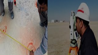
thank you Sir, for your efforts, but just i want to know how the guy knows the last two points? is it by laser or what i mean how he knew whre to put the red paint exactly? thank you again
sir please answer my question is that if we go to new site and we dont have any Bench Mark .but we the drawing of site.then ho we start our job.how we set the machine.explain to me in your office or room theory and practical please please please
hey profisseur aamir thank you at your efforts but i have some questions what is the Coordinates of your station and what the Coordinates of the first and second points and why you put in the chain case 0.00 and how you work without reflecture ? thank you at all
yes it's possible to reference line with fixed points or already saved points only you need to go find an option write point name that it but if you use fixed length like a road survey then use ROAD 2D option
Hello aamir and thank you for sharing your knowledge. I have a question regarding TS set up. When you use reference line function do u need to determine the position and orientation of TS using co-ordinates or only need to level the TS?
If you go through Coordinates then you need to TS setup but if you have 2 points on-site and you need to go with those points then no need any type of setup only set Total station properly and measure those points which are your reference
Sir, how can we draw a perpendicular line to any line. Further, considering that perpendicular line as reference line, how can we mark offset. Pls make a video
Mera tunnel center line asper drawing jaraha hai field may,lakin usi center line ko Bahar tbm say point laykar check Kiya stakeout karkay lakin angle 2mtr right dekha Raha hai kyo?
How can draw nsl and pgl cross section and profile with earth cuting only .i have data both as pr site.in autocad 3d.i have no data in easting and norting.plz sir
Sir topcon me curve porsen ke liye video banaye Q ki sir curve porsen me every chanage rediyas same nhi hota to kese ham kare S. O arc ke liye hamare paas rediyas Or n hi angale he
Mr shahzad my booss works with leica ts09plus he helps me how to use ts09plus but I don't understand putting two known points in instrument for example we have two polygon we know the coordinates but how to put them in instrument please help me I am amator but I want to learn ts 09plus
HELLO SIR , PLEASE MAKE A VIDEO ON THE TOPIC ARE :- (1) HOW TO SHIFT TBM . (2) HOW TO SHIFT FLY TBM . (3) HOW CHECK THE REQUIRED EXCAVATION LEVEL BY MAIN TBM OR ALSO ANY ONE FLY TBM VALUE . (4) HOW TO CHECK THE TOP AND BOTTOM LEVEL OF ANY EARTHCRUST LAYER BY MAIN TBM OR ALSO BY ANY ONE FLY TBM . (5) HOW TO CALCULATE THE QUANTITY OF EACH AND EVERY EARTHCRUST LAYER BY USING THE OGL DATA WE ARE TAKING FROM INITIAL STAGE OR BEFORE EXCAVATION STARTS. (6) HOW TO MAKE EXCEL SHEET FOR THESE ALL WORKS AND CALCULATE .


Who says you are not a good speaker! You are best. Thank you for your teaching
No u r the best. English doesnt matter. U r my insperation
Thanks
@@aamir.shahzad Most wc j
You are good human been who share experience and knowledge with others who new to this field. Thank you very much and appreciating what you are doing to public. Keep it up and hope you may get valuable person in YOU TUBE. Good Luck.
you r great teacher friend i am from iraq ur language is very clear
Thanks Sir
It was very good and you should don't worry about English. You explained and tried very well.
Thank so much bro you are a very good teacher and you'r a good man god bless you bro.
thank you very much dear
Sir mai aapse babut khush hu sir nyc teaching....sir
Sir u r great personality allha always blessed u and your family. Thank u very much
DEAR SIR We understand your topic clearly even that If your vocabulary is weak but don't worry.. We have been learned alot of things from you ,, You are the Great one..
thanks for support
Very well explained and nice effort, keep it up.
You are very good and you’re teaching very well, thank you so much
Mr Amir shahzad thanks for all videos very good and explained very well god be with you
Your welcome Barjon & thanks for nice comments
Sir this is your greatness, your English and vacobulary is good enough to make us understand you are fantastic you explained very well ................THANKS JAZAKALLAHA👍👍👍👍
Thanks so much sir for sharing your brilliant knowledge with us❤
follow you from dubai and saudia thanks alot
Ap boht achy treaky sy smjhaty hn bro...thnks.
thanks Bro
You English is excellent thank you
So nice of you
you are doing great job sir
Thank you for the video and sharing experience. This gives a lot help for my tomorrow work. Best!!
you are welcome it's a pleasure for me
sir ✌🏻👌👌 work matters more than language
thanks
good job dear Allah pak ap ko hamesha slamat rakhe
Ameen & Thanks
Thanks so much for this video... that was very clear..
Amir shab u r great
Eid muhbrak and thanks sir
Eid Mubrak bro and your welcome
Bro I have Subscribed Your Channel And Keep Making Videos By People Demand Ok
Thank you so much Sir, you are very kind to share... I like your videos.. Warm regards from me, from Indonesia....
your most welcome
i think you ara the 1st person who comment on my video from indonesia, belive or not but its mean full for me
Very helpful Amir bhi and we understand as well.
thanks for appreciate
Dear great job God bless you
Thanks & Ameen
You are great. Thank you sir.
Thanks and welcome
Tq sir....Your valuable class.... Really tq soo much
It's my pleasure to be a part of this
MashaAllah nice sharing 👍
جزاک اللہ
Sir u doing a Grt Job ...
Thanks
Good post with information knowledge sir
Nice information dear ❤❤❤
@@Ibrahim_2k-e3r
Thanks
Good job aamer Bhai thank u
Very very useful sir
Thanks
Great job sir thanks for doing it for us
your welcome alway s bro
kidir chala ga ho khoi rabta nahi?
Assalam valekum sir I'm Saida add my wt app no ur group 7396823833
Good morning, thank you for your videos that you share every day they help us a lot. Can you make a video for us how to do a link traverse when you have a road of maybe 20 km how to establish control points and at which distance is better. thank you
Good Morning Dear & thanks for comments on my vidoe
i will make a vidoe on your topic soon
can you please clear to me how you want to establish points and which instrument I mean with GPS or Total Station?
aamir shahzad By using a total station and a GPS or suppose you have at least 3 known points and you want to establish intermediate stations and adjust at the end the traverse to eliminate errors. what are the steps to follow
Sir plz make a video on offsets of various points in an alignment , shift to all 5m apart in other straight line.
Zbrdast sir❤
Thanks
Great job sir
Thanks
your doing a great job I am Surveyor in Pakistan Sindh Plz Add Your Group Sir
Thanks
Sir plz bataye kya ham sokia cx55 building marking me use karsakte hain
Aamir you are good. Let there be more such videos to guide me.
You can find more videos in playlist
ua-cam.com/video/pxtfOmOOcjw/v-deo.html
thanks bro for this video
Any time
IT WAS SO GOOD....THANK YOU BROTHER,,,SPECIAL THANKS FOR EXPLAIN IN ENGLISH
PLEASE IF POSSIBLE EXPLAIN REFERENCE ARC AS WELL
GOOD LUCK
1st thanks for appreciate to me with nice comments and 2nd I will explain step by step every think when i have a time
very good explained sir
thanks
brother urdu ma apki bat sahi smjh ah jati hai kindly urdu ma he vedio bnaya kare
Very nice sir..useful
THANKS
AOA, Sir sokkia totaal sy cutting nikany k leay topoo kaisy krty han with assume cordinates.
Thank you very much
You are most welcome
Great human
Thanks for the video. Question, why you don't use EDM mode "tracking" to find the 0 point more quickly, instead of taking reading every time?
Great
Thanks
its really cool sir...
Thank you
It's glad to hear from you. And our case, we are constructing a Cement Factory which have this type of IPs a lot.
There are number of plates on Slab, Column face, Silo shafts, beam top and side. Issue was it's difficult to setting out positions of plates on slab. Especially there are not only linear arrangement but also radial as well.
1. There is no supports to place Total Station firmly, On top of plywood surface it vibrates more hence instrument level getting out.
2. No high spots besides to respective building.
3. But positional accuracy is needed to be maintained in well condition
Could you please assist us to layout IP locations accurately?
HI Mr.Fifas Ahamed
I read your comment and I can make a video on this topic but I cannot understand the meaning of IPs
@@aamir.shahzad Insert Plates
Very good thank you sir
Great bro
Thanks dear brother
Thanks sir
Very Nice
Thanks Janab
Sir.
Road (Highway) Construction me Traversing konsa method se karna chahiye. Iska answer ya phir Puri detailed me ek video upload karein please...
Me India se hu...
thank you sir
you are welcome
Nice 👍👍👍👍❤❤❤
Many many thanks
Hi. How we move from global coordinates to local coordinates for setting out the total station? Thank you
Asalam o Alkium Sir
total station main qibla direction maloom krny ka tariqa bta dy agra ho saky to plz
Agr old video hai to link send kra dy
Hi dear Can I question with you....?
who can i Added one page in surveying at working
thank you Sir, for your efforts, but just i want to know how the guy knows the last two points? is it by laser or what i mean how he knew whre to put the red paint exactly? thank you again
your welcome
in this video i observe 2 points on ground with non prism and lasir and person who put red pain he can see the location of laser
thank you again
Sir, how we check it's 5 second TS or 1 second TS..? Plz explain it?
Asalamualikum sir how are you i am asking you how to calculate building height if given two verticle angles sir plz tell me mathod
salaam! sir kisi b new place py jaa k kaam kysy start kr skty hyn ? even we dont have any one coordinate
Boohat hoob.Sir g ap say ek Guzarish hain kih Leica k sat sat SOKKIA 650 TS k bary main B kuch video uplode karon .Thanks
650 mara pass nahi ha likin agar kisi dost k pass hoi to zaroor
sir please answer my question is that if we go to new site and we dont have any Bench Mark .but we the drawing of site.then ho we start our job.how we set the machine.explain to me in your office or room theory and practical please please please
Can you share a video of setting something up
hey profisseur aamir
thank you at your efforts
but i have some questions
what is the Coordinates of your station and what the Coordinates
of the first and second points
and why you put in the chain case 0.00
and how you work without reflecture ?
thank you at all
HE STARTED FROM FIRST POINT SO THE DISTANCE FROM ORIGIN(FIRST POINT) = 0.0.....
HE USED NON PRISM METHOD , LASER POINT
AS YOU CAN SEE ON HIS EDM'S SCREEN ON THE LEFT -TOP THERE IS A HOUSE WITH LASER .
there are this otion in the ts02 ?
how can i activete it in the ts02
i think have this option
thanks bro for better explain
Hi Aamir, very good information, but please can you tell me if I can make a reference line based on Fixpoints ? already uploaded in the job ?
yes it's possible to reference line with fixed points or already saved points only you need to go find an option write point name that it but if you use fixed length like a road survey then use ROAD 2D option
Nice 1...
Thanks AMjad ali, its long time when you write some thing on my video
aamir shahzad Bhai sorry main kuch time k lye offline tha..eid Mubarak...
Khair Mubrak or ap co b Eid Mubarak
khoi bat nahi main asa he pocha tha
Ji Bhai hum Ku incline colum ki degree pata karna hai total station se so please explain
Hello aamir and thank you for sharing your knowledge. I have a question regarding TS set up. When you use reference line function do u need to determine the position and orientation of TS using co-ordinates or only need to level the TS?
If you go through Coordinates then you need to TS setup but if you have 2 points on-site and you need to go with those points then no need any type of setup only set Total station properly and measure those points which are your reference
@@aamir.shahzad Thank you.
Good work sir
Thanks
Sir total station ts02 lazer on of waher options
hi what is the difference between measure and distance?
if you press the measure button then it will save automatically in the instrument but if you press distance then it only shows the values
great video
thanks
Sir, how can we draw a perpendicular line to any line. Further, considering that perpendicular line as reference line, how can we mark offset. Pls make a video
use reference line or road 2d
this method also you can use for perpendicular offset
where can i find leica ts16i apart from india or pakistan
Resection ke time kitna mm rhega to age kam kar skte hai
Thanks
You are welcome
Mera tunnel center line asper drawing jaraha hai field may,lakin usi center line ko Bahar tbm say point laykar check Kiya stakeout karkay lakin angle 2mtr right dekha Raha hai kyo?
Sir in same video there is measure point and stake can u explain about that sir
yes i will explain in next videos
Morning sir? How Look for * in calculator here?
Assalamu Alaikum Wa Rahmatullah Madira Jo video Kiya total station main Leica controller Mein sem video Karega to
Thanks Sir!
your welcome
Assalm alaikom sir, sir trevers survey k bary completed batao taky samaj ajay. Yhanks
Sir gps point kaise TBM me deta he 1st settelit na ajum karke. ...grx2
Can I get ts 09 used machine
How can draw nsl and pgl cross section and profile with earth cuting only .i have data both as pr site.in autocad 3d.i have no data in easting and norting.plz sir
Make NSL & PGL 2 surface and then make the surface a profile and then add bands
Sir topcon me curve porsen ke liye video banaye
Q ki sir curve porsen me every chanage rediyas same nhi hota to kese ham kare S. O arc ke liye hamare paas rediyas Or n hi angale he
also loading how to setting gps to setup or find a co ordinate with elevation
Soon I will make
Mr shahzad my booss works with leica ts09plus he helps me how to use ts09plus but I don't understand putting two known points in instrument for example we have two polygon we know the coordinates but how to put them in instrument please help me I am amator but I want to learn ts 09plus
in instrument 2 option
1. put 2 points and then find & fix
2. observe 2 points and use as a reference
HELLO SIR , PLEASE MAKE A VIDEO ON THE TOPIC ARE :- (1) HOW TO SHIFT TBM .
(2) HOW TO SHIFT FLY TBM .
(3) HOW CHECK THE REQUIRED EXCAVATION LEVEL BY MAIN TBM OR ALSO ANY ONE FLY TBM VALUE .
(4) HOW TO CHECK THE TOP AND BOTTOM LEVEL OF ANY EARTHCRUST LAYER BY MAIN TBM OR ALSO BY ANY ONE FLY TBM .
(5) HOW TO CALCULATE THE QUANTITY OF EACH AND EVERY EARTHCRUST LAYER BY USING THE OGL DATA WE ARE TAKING FROM INITIAL STAGE OR BEFORE EXCAVATION STARTS.
(6) HOW TO MAKE EXCEL SHEET FOR THESE ALL WORKS AND CALCULATE .