Climate Risk Analysis Using GIS Webinar: Applied Meteorology Using ArcGIS

Вставка
- Опубліковано 18 вер 2024
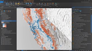
- Assessing climate impacts and areas at risk requires an interdisciplinary approach, leveraging data from demographics, social sciences, and environmental applications that traditional weather analysis packages are not optimized to handle. GIS technology gives the user virtually limitless potential to analyze and contextualize data from a multitude of observations and models to identify climate patterns and impacts. In this webinar, attendees will learn how to perform mapping and analysis of weather, demographic, and environmental data using ArcGIS software and Python tools for desktop and online environments.
---------------------------------------------------------------------------------------------------
Follow us on Social Media!
Twitter: / esri
Facebook: / esrigis
LinkedIn: / esri
Instagram: / esrigram
The Science of Where: www.esri.com


Wow... really enlightning
Thank you!
would you mind sharing the data?