Understanding Latitude and Longitude and Using Degrees Minutes and Seconds on Maps

Вставка
- Опубліковано 3 жов 2024
- Instructional video explaining what latitude and longitude are and how they are represented on maps. It also covers how degrees, minutes, and seconds are related, and how you can determine the degrees, minutes, and seconds a particular point is at.
NOTE: Around 13:30 I accidentally say 75 minutes instead of 75 seconds. It is written correctly, I just used the wrong word in describing it.


Came here after going through a few other videos and nobody explained it the way you did. Goes straight into the brain :D
As a geographer and someone who has several lat-long videos online I appreciate that you want to teach these concepts, too!
Awesome! These videos were originally meant to be companion videos to my fully online geology lab class but I figured if other people wanted to check them out that was fine too!
i think of lattitude and change the word to LADDER, as in up and down. so if you are not going up or down then it would be LONGITUDE as in LONG lines
That's a pretty good way of remembering it!
Great explanation!!!!
The way you explain it so wonderful and easy to understand. You are for me one of the great teacher. Thanks
You are welcome!
I was afraid I would never understand that, but now I owe you, many, many. Sorry, I don't know what else to say, just thank you.
You are very welcome. So happy I could help.
Outstanding explanation of something I feel like I should have understood before, but honestly didn't, despite prior attempts to do so. Really informative; thanks.
I am glad it was helpful. It is really not that hard, but it always gets overcomplicated I think!
You did a great job of uncomplicating it.@@ruppertrocksgeology
I’m studying for my Captains license and getting ready for chart plotting. Your explanation was the best I have found!
Oh thank you! So glad it helped!
I love you mam ❤just made me love geography.
Is it profoundly coincidental that when I lived with my Grandparents in Augusta Ks. in 1982 with bedroom at 37.675870 N lat then 40 years later now live in California with bedroom at 37.675870 N lat, same!?😱
That is definitely amazing!
Wow!!!!!😮
Wait what? So you were at the same Northern latitude exactly?
Wait what? So you were at the same Northern latitude exactly?
Exactly what I was looking for! This should have more views
Thank you! Tell your friends to watch! 🙂
You are a very good teacher.
Thank you!
Hahaha you are so funny and can explain well , keep it up , never give up ! ❤❤❤
Thank you!
@@ruppertrocksgeology always welcome just keep doing videos , I shared ur videos to my friends and they learned many things !
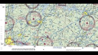
33°56'15"
117°30'37"
Why isn’t it 33.5 degrees since it’s between 33degrees and 34degrees😢? But either way this is an amazing video!! Thank you so much!!❤❤
If you look at the bottom of the map its latitude is 33 52 30. If the bottom was 33 THEN the midpoint would be 33.5. But instead, you need the midpoint between 33 52 30 and 34.
Nice explanation. Thanks
Welcome!
Thank you so much. You did a great job explaining it all 💯
I’m so glad this was helpful. If you have other topics you need help with please let me know. I can record more videos!
Lip 0:26 0:27
Very good explanation. In the business, we label longitude “West”, instead of using the negative.
Yeah I have seen it done both ways. I used ESRI software for a long time many many many years ago and so the +/- was often used there for obvious reasons.
Some people can talk and some people can teach, you definitely fall into the second category. Your explanations and diagrams were concise and very easy to follow.
Thanks for a great video.
That is a lovely compliment. Thank you! I do love teaching!
Thank you for sharing 😁.
You are welcome!
Ma'am I have doubt in terms of longitudes:
1.I agree with your statement that moving from point A to be B longitude value decreased so the object is moving west
2. But we cannot say whether the object is on east or west of prime meridian without sign, how did you say that object is on west of prime meridian?
If the intial starting point was 117.5° and ending point was 117° then object could've been on any side (assuming i didn't mention sign)
Hello! Great question. Assuming north is "up" on your page, we know that when the longitude increases to the left it must be getting further away to the west from the prime meridian. When the longitude increases to the right it must be getting further away to the east from the prime meridian. They numbers keep getting bigger west and east of the prime meridian until they meet at 180 degrees which is both 180 degrees east and west of the prime meridian.
@@ruppertrocksgeology Got it, imagining the movement over a flat map helped as you told. Thanks a lot ma'am.
Excellent job.
Thank you! I am glad this is helping people in and outside of my class!
Learning for sUAS test. Invested 15 minutes in this video and completely understand the concept now. Good stuff👍
Yeah! I have had a few others in a similar situation to yours using this video which is great!
@@ruppertrocksgeology I was so excited to utilize my new skill on the test, but they didn't ask a single coordinate question! Still passed
@@RenaissanceReggie Congrats!
Wow!! Thank you for simplifying it and making it easy to understand. Great job.
Well thank you!
Know I know how to do it 🎉😂❤
Great! So happy to help!
Thank you!
You are welcome!
Excellent 😊
amazing
I am glad it was helpful!
excellent explanation!
Happy to help!
Thank you❤
You are welcome!
Thanks so much, very clear teaching and also clear handwriting!
So happy this is helpful!
How come the first number is 33.5? Cause it’s between 33 and 34 latitude.
Thanks?
If you have any two whole degree numbers on ends the middle will always be XX.5 or XX and 30 minutes and 0 seconds. That is right in the middle of the degree!
THANK U!! THIS WAS SOO HELPFUL
I am glad I could help!
Interesting, what do you think of the Gleasons map?
Greetings from Los Angeles! Thank you very much for making this video! I'm studying for an FAA license, and this was very helpful!
Awesome! I am always happy that people can use the information for such different reasons!
Best example mam easy way for me to understand after too much searching
I am so happy you found this useful! I try to make it simple but still address some details!
You're awesome. You explained it right.
I am glad it was clear (and correct)!
thank you for this😇
Welcome!
Thank you
You are welcome!
💯
Mam u are great u make it very simple
I am so glad this is helpful to you!
I don't know if you know this, but someone ripped off one of your shirt sleeves! I still managed to learn a lot though despite that lol. I used to use maps a lot and this was not only a good refresher, but even taught me a few new things!
Ha! Yeah unfortunately a store convinced me to still buy it that way. :-) I am glad the video was useful!
Great explanation! Thanks for posting.
Glad it was helpful!
Thank you. You did explain it well but I have a question. Is the time based on some speed that you would be traveling?
Hello! It is not based on a speed you would be traveling. Here is a quick explanation:
In early human history, it was observed that the year was about 360 days. Of course eventually we found out that this was not quite right - but it was pretty close!
As it was an observable pattern, the idea that a circle should have 360 parts (or degrees) was invented by the Babylonians.
Since this original idea was based off of time (how long a year was) it made sense to break this down further by units of time (minutes and seconds). It also helps that you can divide 360 degrees evenly by 60. So 60 seconds in a minute and 60 minutes in a degree is where we landed.
@@ruppertrocksgeology Another way to think about it is by looking at what the words minute and second really mean. We also use the word minute just to describe something that is small, and that is indeed the origin of the word minute. In time or angles t is a smaller subdivision of an hour or a degree (which are each already a subdivision of a day or a circle.) When time keeping and angle measurements required even finer granularity, a second (as in 2nd) subdivision was added, simply referred to as the second subdivision, or shorter simply "second".
@@michaeldamolsen Thank you for your contribution here. Hopefully this will further help students (and others too)!
Thankyou for the explanation. I'm reading about Shackleton, and when longitude and latitude are mentioned it will make more sense.
I am glad this was helpful!
Thank you
You are welcome!
very claer and brief than you
You are welcome!
Teach it to me like am I’m 3, good Job!
I know this is probably easy for some who are familiar with latitude and longitude but if you don't use it all the time it is easy to forget and get confused!
Can i ask how to pronounce 38° 53' 35' N and 77° 00' 32'W
38 degrees 53 minutes 35 seconds north and 77 degrees 32 seconds west
Why are you drawing a rectangle instead of a circle?
You can choose any shape for map boundaries, but when we talk about latitude and longitude it makes sense to use two vertical lines for longitude and two horizontal lines for latitude.
I chose this shape because 7.5' maps are this shape at this latitude and longitude.
Can I contact you I'd like to ask a question on this I'm confused
You can leave a question here! It is finals week so I am a bit busy but if I have time to answer it I will!
@@ruppertrocksgeology it's just I have a picture of coordinates it' confusing me
Why is latitude only up to 90° but longitude/prime meridian 180°? Theyre both the same totoal potentiap distance???
Hello! For Latitude you can think about how if you are at the center of the earth and point to the equator, and then use your other arm to point at the north or south pole you would form a right angle (90 degrees). If you are at the center of earth and point to the prime meridian you could swing your arm around 360 degrees to complete the whole circle. We could just go east and go from 1-259 degrees but instead we do east 1-180 and west 1-180 to complete the circle. But there are other ways you could do it. I hope that makes sense!
Excuse me can u please help us if I was given a latitude and longitude of a point and distance and I was asked to find out the other lat and long of the other point
Does it give you a direction to go?
ty
You are welcome! Glad it helped.
Very good explanation mam..
But last part some how confuse..
Let me know what needs more clarification and I am happy to add a video.
I have read texts and watched a few videos explaining this, and they all explain how to interpret or convert DMS to and from decimal degrees, but none have explained why use this system instead of decimal degrees, or where the convention comes from. Why? When is it actually relevant? It would be helpful to know.
Hello! A lot of it comes down to tradition. With computers and GIS advancing dramatically in the last 20 years that is changing, but of course old habits die hard. Additionally, in the corners of traditional topographic maps, there are the coordinates listed using DMS. And sometimes along the bounding lines additional points are notated this way. This is the case for some of the maps I use in my lab class which is why students need to know how to use DMS. And finally, there are still a lot of references to 7.5 minute or 15 minute maps. This gets clunky if we were to change all of those references to 0.125 degree or 0.25 degree maps. I hope that helps clarify why this is likely still used! Maybe the younger generation will help phase these traditions out! 🙂
I'd love to know what "lab" you had assigned to your students. I am currently teaching this chapter and have been sifting through different engaging actitivies.
I wrote my own lab manual as my lab is 100% Online at Coastline College. So it has a different feel than a face to face lab. This was lab #1 on Topographic Maps. Does that answer your question?
Who came here from DCS community ?
I am curious to know what DCS community is?
@@ruppertrocksgeology it's a realistic aerial combat simulator on the computer
@@willazeppeli Oh! That is not what I was expecting at all!
You made a mistake @ about 13 38. 30 + 45 is 75, but minutes is a no no. It all makes sense now why the Mrs spends so long getting ready :)
Thank you for catching that. I said 75 minutes instead of seconds. I am putting a note in the- description!
@@ruppertrocksgeology You are very welcome. I think Steve Hawking would still be proud. Enjoy your 86400 seconds.
Review. You inverted what is latitude lines and longitude lines speaking following the 7.5 scale lines with your finger.
Can you tell me what approximate time that is at? I can take a look and see what happened?