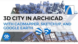
Free Real 3D Landscape with Buildings in ARCHICAD using CADMAPPER

Вставка
- Опубліковано 25 сер 2024
- ► PROJECT FILE bit.ly/3msgQ9G
► Basic Floor Plan Tutorial From Scratch! • ARCHICAD Tutorial # BA...
In this tutorial we will be using CADMapper and create a landscape from realworld GIS data for Archicad.
Software used: Archicad, CADMAPPER
Socials:
Instagram: bit.ly/472RB4o
Support me on Patreon: bit.ly/3msgQ9G


Thank you! Though it is crazy that so much work is still needed for such an important task
Thank you for the highly informative tutorial 🔥. Your humour is also on point 👌😂
thanks
👍🏼
Thanks, you are doing great work.
Very useful.thank you so much
1:34,why not use archicad file instead using sketchup file?
it doesn't give 3d data, only 2d drawing.
OK,thx!@@sb.architect
How to remove plane which is coming underneath the contour model
I cannot achieve what your showing because of that plane
Please help what to do