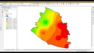
The following video tutorial will describe you how to Interpolates surface using Ground survey GPS elevation points. Please subscribe our channel ; Geomatics Acadney
@@geomaticsacademy2427 I tried using iteration for generating multiple grids from a single excel file for 365 daYs but model was not ready in working condition .Can you suggest what structure could be followed in model in order to genarate grids for 365 days In a single command
@@geomaticsacademy2427 That's great!! I was able to figure it out eventually but I think it would be good to have a video as I couldnt really find any resources online!
To open an attribute table, right-click a layer or table in the table of contents and from the context menu choose Open Attribute Table. You can also use the keyboard shortcut CTRL+T to open the attribute table of any selected layer in the table of contents. Then observe missing data carefully by scrolling in each row of attribute table.


hi there can I interpolateand generate multiple grid using the model builder and spline interpolation tool . Kindly help
Hello Sadiya , Yeah you can do it in model builder by just adding this spline interpolation tool into your model.
@@geomaticsacademy2427 I tried using iteration for generating multiple grids from a single excel file for 365 daYs but model was not ready in working condition .Can you suggest what structure could be followed in model in order to genarate grids for 365 days In a single command
@@sadiyaidris4819 I think You should code for it, in Artificial numeral network or other statistical prediction tool or model
can some one plz tell me how to get this data of my selected region , or pollution data of a region ,, reply fast 4 project
Hi, when i try the interpolation it shows Error 010092 which says "Invalid output extent". How do i solve this issue?
I think you should define output extant
Hi, would you be able to tell me how I can calculate RMSE of an interpolated surface versus another raster that would be the true value?
We would like to make a video for you regarding your question
@@geomaticsacademy2427 That's great!! I was able to figure it out eventually but I think it would be good to have a video as I couldnt really find any resources online!
Thanks madam we also want to learn from you, If you have certain notes or link kindly share.
Thanks
i realize Im pretty off topic but does anybody know of a good site to stream newly released series online?
@Jesse Stetson i watch on FlixZone. Just google for it =)
how attribute table show missing data
To open an attribute table, right-click a layer or table in the table of contents and from the context menu choose Open Attribute Table. You can also use the keyboard shortcut CTRL+T to open the attribute table of any selected layer in the table of contents. Then observe missing data carefully by scrolling in each row of attribute table.
Hi can I ask for your email? i need with creating maps on arcGIS. Please reply. Thank you.
Yes sure
hi, can you make video on binomial prediction kriging and gaussian aral kriging ?and can you please share your Email address
Yes sure
E-mail address?