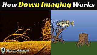
Deeper Chirp +2 Sonar Fish Finder or Survey Tool?

Вставка
- Опубліковано 28 вер 2024
- How well does the Chirp +2 Sonar perform as a mapping/survey tool? Lets take a look at the Bathymetry data that was collected while mounted to an autonomous survey boat!
Research paper utilizing the Deeper Sonar also.
deepersonar.co...
Download Bathymetry maps here - maps.fishdeepe...
How to use Mock Location to connect to RTK - • How to use Android Moc...


Nice video. I am considering purchasing one of these for research purposes. Specifically, I am interested in bathymetry mapping and calculating water volume of small pools (on average around 15 x 20 m). I have a bait boat that I could mount it too, or could do cast and retrieve from shore. In your opinion is the additional GNSS receiver necessary to get sufficiently fine scale data to achieve my goals? I have used a Lowrance Hook Reveal 7TS mounted to the bait boat but the data were often unusable. Much of this seemed to be due to the GPS receiver in that unit not providing very accurate readings. Note that these small pools are under tree canopy cover. Any advice you can offer is appreciated. Cheers, Mark from Western Australia
you misunderstood me, I mean the map where you can see where the deeper one was located
Could you please provide the Deeper csv files.
where can I find this map?
Here is a link to Deeper's Web app. There are many lakes from all over the world including the one I collected from other deeper sonar's as well. However I believe you need a monthly subscription to access them all. maps.fishdeeper.com/en-ca