But i think these knowledge is easy, maybe you could use ArcGIS Pro do more challenging tasks about deep learning if you can. I think that must be more attracting and interesting
With kind respect.Sir can you please make some deep learning tutorials on analysis by dive into insights and discover trends and patterns for prediction and research.
Dear sir this is great. I'm in south africa and an engineer. I'm busy compiling data for hecras from geotiff. Please cab you advise where this geotiff was derived from
Thanks for the video, but i have a question, how can i place the scale and north arrow in the map itself (like in QGIS), to see them as i zoom in or zoom out and seee the direction of the map? Thanks, and keep up whit the good work.


Perfect ..well done .. Thanks
I am a student majoring in GIS, i think your video is so helpful, thank u
But i think these knowledge is easy, maybe you could use ArcGIS Pro do more challenging tasks about deep learning if you can. I think that must be more attracting and interesting
Glad it was helpful!
This is as great as all your other tutorials. Thank you so much!
Glad you like them!
Thank you for this video. I'm just learning cartography and this video, I'm going to be using for reference. Thank you.
You are welcome :)
Nice video
Thanks
With kind respect.Sir can you please make some deep learning tutorials on analysis by dive into insights and discover trends and patterns for prediction and research.
May you could use Python to do these tasks, I think the ArcGIS Pro is more restricted than Python.
Thank you! So helpful!
Glad it was helpful!
great and straight forward
Thanks :)
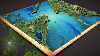
Dear sir this is great. I'm in south africa and an engineer. I'm busy compiling data for hecras from geotiff. Please cab you advise where this geotiff was derived from
Its SRTM data downloaded from USGS
Amazing
I'd really like to make a map like this but for a different part of the world, where can I find the data needed? will it be open source?
Thanks for the video, but i have a question, how can i place the scale and north arrow in the map itself (like in QGIS), to see them as i zoom in or zoom out and seee the direction of the map? Thanks, and keep up whit the good work.
Great work, do you know how to make a consult map for economic data for a specific country?
thank you! this helped!
Sir please provide the data
Added the link to download data in the description
Promo-SM
ArcGIS software is too expensive.