Introduction to UTM coordinates and Grid References (simple)

Вставка
- Опубліковано 14 лис 2023
- This video goes in to some basics details about both UTM coordinates and Grid Reference and how to use them. It describes how UTM coordinates and Grid References are taken from a map and what is the correct way of passing information about your UTM coordinates or Grid Reference to others, such as a mountain rescue team.
Two other videos are mentioned in this one:
Finding the exact 1cm square at the very centre of Great Britain.
• The real centre of Gr...
How to use a compass to accurately get UTM coordinates and Grid Reference from a map.
• UTM coordinates & grid...


Great video. This is what UA-cam should be used for.
Great video and very well explained! I am ex-military and we used an expression similar to the British one: "you enter the house and then go up the stairs". 😊👍👏
I dimly recall a Drill Sergeant beating into my brain the phrase “To the Right, and Up.” It’s still there!
I've always used the phrase "onwards and upwards" to remind myself that eastings come before northings. Another great video. Thanks.
Another cracking lesson. Many thanks for explaining this so clearly.
I'm glad you enjoyed it
Another super useful video, very well explained. Thanks very much!
Easy to follow and understand tutorial. Very good job of simplifying what could be a confusing topic.
I love the accuracy of UTM but find myself switching back to other grid systems simply because my friends mostly use a gps unit and use WSG84 (google earth etc). So Decimal Degree is often the default in most handheld gps units. I use it for mostly trip planning on foot. Great video.
Their GPS units should be able to switch to UTM without much fuss, I haven't found one yet that didn't.
First you need to identify which moon. Then which side? If you are on the dark side take a flashlight. Here in New Zealand we are upside down. We say "Eat before Nourished" Our parallels are written Negative. (_ve). or "South" My town Te Awamutu is nearly dead on the 38 degree South Parallel. When Juliet wanted to find Romeo she had no map so she could not get a grid reference so she said "Romeo, Romeo where for art thou Romeo?" He replied "I;m over 'ere".
We have only one Moon. The other have additional name.
The side is not a problem, but the video was simplified on such part: For grid coordinates you need a Cartesian grid (or good approximation): as you see, on the sides, one km walking is shorter then one grid km square. On Earth UTM divided in 60 zones, we should do the same on the Moon, or any other projection. So too complicated for the video. And in any case we need to define origin and direction (and more) for every grid coordinates
The other moons are hiding.@@GiacomoCatenazzi
Greetings from Australia. Love your channel, love your vibe!
Great video I am still working on this stuff, just for brain food. Need a lot. I have good local knowledge of my area and a 65s helps my main problem is getting hold of good maps.
Very nice.. Thank's for the video
Thanks Wayne.
Thank you!
Greate video. It's helping alot😊
Nice...👍.
👍
Was taught in Scouts, “In the house, up the stairs.”
Great
Could you do also a video about the complexities? Just for curiosity, not real use. In the first version you added the meaning of the UTM numbers (I agree it was unnecessarily complex). But how it works in Norway (from your picture and my memory, there were an unconventional shape).For real navigation (so sea) seamen use geographic coordinates. I wonder how complex would it be for land navigation on OS maps.
For the other viewers: the "right and up": very normal (x y coordinate order), but it confuses many because it invert common usage with geographic coordinates.
If I pick a point in Google Earth it represents it as yy°yy'yy"N, xx°xx'xx"W for example. Isn't that poor form according to what you explained. Seems like they should give Longitude then Latitude but i see this representation a lot in other applications. Thanks for the video
@13:27 You switch from UTM map/zone 12 7211290E 4343660N to 17 452564E 4434984N for the same “campsite” ?
Zone 17 is a different map.
You can see that at 13:27 the map is of Cambridge in Ohio
In what contexts are the coordinate systems Degrees, minutes, seconds used?
Degrees are just the amount of circular rotation around a point. This could be your location or anywhere else. The circle (surrounding the point) is divided into 360 and the amount of rotation is described as degrees.
Each degree can be divided into 60 minutes and each minute can be divided into 60 seconds. This can give a very accurate direction from the central point to another point.
@@TheMapReadingCompany I have seen similar systems in industry, but there to measure precise angles. Degrees, minutes, and seconds. You have a so-called sine ruler with a given length, (the hypotenuse). You build up (opposite side) with carefully ground bricks of different thickness. Then you have two lengths and a right angle and can then calculate Alpha.
That’s all well and good but 1-50 maps are only printed to a certain accuracy is it to the nearest 100m? It’s something to do with how the ink goes onto the map sheet and it stretching ect. So anything over a six figure grid reference is a bit of a guess
Here is a video which may interest you. I went looking for a 14 figure grid reference (a 1cm square) at the center of Great Britain. ua-cam.com/video/KgGOnqPa4e0/v-deo.htmlsi=QUidSNmZcottiWPg
I wondered how small the grid error in distance would be, due to the OS map projection onto a flat surface. I checked out distances on the OS map near Muckle Flugga (60.8561 deg N) and Newlyn Tidal Observatory (50.1031 deg N) compared with distances on a geoid. According to my calculation, there is only a 0.3% difference that's less than I expected!
Have a look at the OS's take on this.
www.ordnancesurvey.co.uk/documents/resources/guide-coordinate-systems-great-britain.pdf
@@TheMapReadingCompany Both of my locations are close to the central meridian (2 deg W) and I found that the Scale Factor was more important than the effect of latitude. Both are completely insignificant but map projection is a fascinating, if complicated subject!
When using a coordinatometer with a 100m precision, is there any convention in which number to choose while rounding?
Example, let's say my point is between 2 and 3 east, so I have to give my coordinate like 317200 or 317300. If for example we all agree globally that I have to use always the lowest number, my rescuers or whoever would get to 317200 and know that I am within 100 m, but surely towards East (plus whatever it should be for north south, same reasoning)
Sorry I don’t know what a coordinatometer is.
As for rounding location details as far as I know there is no universally accepted method other than to round to the nearest whole digit.
As an example if you were at 12.3 - 56.7 this would be rounded to 12 57
If you were at 12.34 - 56.78 this would be rounded to 12.3 - 56.8
Etc.
BUT the main point is to “always” give a descriptor.
“I’m at 12.3 - 56.8 near the waterfall” or “I’m at 12.3 - 56.8 at the end of the ravine” This will solve all rounding problems as the person receiving the message will know exactly where you are.
@@TheMapReadingCompany Thank you very much for your answer. And for the coordinatometer, I don't even know if it is a real word, I very roughly translated "coordinatometro" in english from italian. It's the grid used thing to measure UTMs (which I keep forgetting the name in english, sorry).
Romar scale, that one xD
Do you think you might be Knighted one day for your Services to Navigation?
Yes I think I should - King Wayne the 1st has a nice ring to it
🤣@@TheMapReadingCompany
On the eastlings why are you saying it's in 4? If u count from the left it's in number 5 square?
Hi Ryan, the first column and row are zero, so the 2nd is 1, 3rd is 2, etc. Hope this helps.
@TheMapReadingCompany just wondered why so I know not to count the first square . Thanks for the reply keep the good videos coming very helpful 👍
Great video but why not just use latitude and longitude? A tenth of a second gets you down to about 3 metres.
Did i get it wrong?
You said along, then up…
That would mean you gave the wrong UTM for the campsite as you went DOWN from the nearest grid line.
That would be +340 Northing, not 660…
Or am i missing something here…
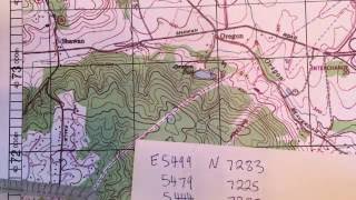
On USGS TOPO maps and OS Grid maps the numbers along each side are the same, so you can use either. Also the numbers along the top and bottom of the map are the same, so you can use either. Normally which you use depends on how your maps is folded. In the video I used the top numbers simply to show the full easting (458000), but as you can see I still went across first, or “along the corridor”, then up or “up the stairs”.
If you are carrying a cell phone, (most people are) why not just give the gps coordinates?
The preference for land navigation is to have a system that directly relates to the distances on the ground and that is achieved by using co-ordinate systems in metres (or feet in the case of the Colorado1983 grid referenced on one of the maps in the video).
I still think QTH is easyer