Herby, there is no question in my mind that the more common term (at least in America) for the tool you were using is "dividers." That may be modified for the rare set of dividers that has a spreading device that allows it to change, open or close, by degrees. The term "compass" is usually reserved for a device that measures degrees. Really like your basic explanations and wonder if that will continue when you start explaining HO249 or sextant use! By the time you have finished, all your subscribers will be proficient navigators, that is, until they try to find the horizon in a foggy sea while going up and down 6' at a time with moderate waves.
As the Chairman of a Tall Ship (55m barquentine) that focuses on youth development, instructing navigation is a core competency. The trainees are only allowed to use paper charts and traditional methods. The many chart plotters and GPS units are generally covered up and accessible to the professional crew. Once the basics are mastered using advanced navigation is generally much easier. Beyond the tall ship I still see very experienced yachtsman and women consistently making mistakes by never having learnt the basics. Ones that readily come to mind are confusing degrees, minutes & decimal with degrees, minutes & seconds - scaling along the longitude axis to very, very, very few bothering to correct their charts via 'notices to mariners'. The list goes on. On our yacht we use paper continuously in parallel to electronic aids. We don't favour one over the other as both have their advantages and disadvantages. A few that come to mind in the paper chart, is great for seeing the big picture in route planning as well as plotting progress. Equally, known obstacles remain on a paper chart (of the correct scale) whereas electronic charts obstacles can appear or disappear depending on the level (zoom in/out) that is selected. Both electronic and paper charts have their limitations and the prudent navigator will use all and every aid to assist with their navigation requirements. To discount one or the other can be dangerous and put life at risk.
@@RiggingDoctor I know charts are kind of a dying thing with little interest. I think its still an important skill to have and think its kinda fun anyways.
I agree! Commercial ships no longer need to carry paper charts and rely solely on their electronics, and the Norwegian Cruise ship lost their electronics from a rogue wave.
I like to write my last position on a post it arrow and point it behind my last position in the direction of travel. If something happens I know my last position and it’s big enough to read easily. Of course I write it my log book too.
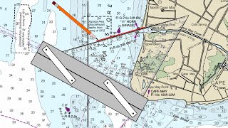
I noticed that you never even mentioned the use of a parallel rule. I'm now retired after 42 years of sailing, on commercial ships, and I used a parallel rule, maybe 95% of the times I've plotted positions.
I always have paper charts, I suppose it go's back to when I started salling , we didn't have gps then. They are a necessity even now!! I don't know if you are following my modeist little chanel or not, but I did make it to Green Cove Spring Marina where I am effecting my lightning damage repairs! your friend Dale
Find this stuff entertaining, been flying 40 years, 20 years ago it was required to have a chart, then came along GPS, don't need charts no more, but you say, what if GPS fails, always have two units and with just about everyone caring a smart phone wala... I could see a good use for a chart, stranded on a deserted island, good way to start a fire...
Haha! Yeah, paper is definitely our ultimate backup. I just wanted to make sure I stayed practiced with it so I made it the first thing we used! After I figured out where we were, I would then check my coordinates with the “real” coordinates from one of our many gps units.
I think sailing is a bit different from flying. Paper charts are very important to us. If lightening strikes and you lose your power source in the middle of the ocean, a second gps and a smart phone will not help you.


Glad to see such a bright light teaching navigation.
TFS good information on how to find your coordinates on a chart.
Herby, there is no question in my mind that the more common term (at least in America) for the tool you were using is "dividers." That may be modified for the rare set of dividers that has a spreading device that allows it to change, open or close, by degrees. The term "compass" is usually reserved for a device that measures degrees. Really like your basic explanations and wonder if that will continue when you start explaining HO249 or sextant use! By the time you have finished, all your subscribers will be proficient navigators, that is, until they try to find the horizon in a foggy sea while going up and down 6' at a time with moderate waves.
We plan on going through these topics a little at a time!
I’m just used to calling it a compass from masonry (Square and Compass)
Starting with the charting before going on with other navigation points/videos is a good idea. U gotta have the basics down first!!
Another great video!
Really imformative, thank you.
Nice job explaining. Where would I find your video as what you use for depth, ais, gps. Thank you
Depth: Signet Marine sounder (came with the boat
GPS: the radio has a GPS readout
AIS: Vesper XB8000
That’s all the electronics we have on the boat 😂
As the Chairman of a Tall Ship (55m barquentine) that focuses on youth development, instructing navigation is a core competency. The trainees are only allowed to use paper charts and traditional methods. The many chart plotters and GPS units are generally covered up and accessible to the professional crew. Once the basics are mastered using advanced navigation is generally much easier.
Beyond the tall ship I still see very experienced yachtsman and women consistently making mistakes by never having learnt the basics. Ones that readily come to mind are confusing degrees, minutes & decimal with degrees, minutes & seconds - scaling along the longitude axis to very, very, very few bothering to correct their charts via 'notices to mariners'. The list goes on.
On our yacht we use paper continuously in parallel to electronic aids. We don't favour one over the other as both have their advantages and disadvantages. A few that come to mind in the paper chart, is great for seeing the big picture in route planning as well as plotting progress. Equally, known obstacles remain on a paper chart (of the correct scale) whereas electronic charts obstacles can appear or disappear depending on the level (zoom in/out) that is selected. Both electronic and paper charts have their limitations and the prudent navigator will use all and every aid to assist with their navigation requirements. To discount one or the other can be dangerous and put life at risk.
Glad to read this! Thanks for sharing ☺️
Maybe do more videos on chart plotting using charts with different scale and converting from decimal coordinates.
Good topic!
@@RiggingDoctor I know charts are kind of a dying thing with little interest. I think its still an important skill to have and think its kinda fun anyways.
I agree! Commercial ships no longer need to carry paper charts and rely solely on their electronics, and the Norwegian Cruise ship lost their electronics from a rogue wave.
I like to write my last position on a post it arrow and point it behind my last position in the direction of travel. If something happens I know my last position and it’s big enough to read easily. Of course I write it my log book too.
I noticed that you never even mentioned the use of a parallel rule. I'm now retired after 42 years of sailing, on commercial ships, and I used a parallel rule, maybe 95% of the times I've plotted positions.
What charts are you usung? Where do you order them from?
I get them from Maryland Nautical in Baltimore, MD
maps.app.goo.gl/UXx7Zi66R6BHFqiX8?g_st=com.google.maps.preview.copy
Paper charts are great & an interesting & fun way pass the time when passage making especially when everyone gets in on it & compare notes
Hello nice video looking for the next. My father and a grandfather have similar finger ornament. Saludos Ibero
They must have been very good men :)
@@RiggingDoctor yes they did ok Merry Christmas
I always have paper charts, I suppose it go's back to when I started salling , we didn't have gps then. They are a necessity even now!!
I don't know if you are following my modeist little chanel or not, but I did make it to Green Cove Spring Marina where I am effecting my lightning damage repairs! your friend Dale
The last video of yours we saw was when you were giving us a tour at your marina :)
Who knew this was a forgotten voodoo art?
Find this stuff entertaining, been flying 40 years, 20 years ago it was required to have a chart, then came along GPS, don't need charts no more, but you say, what if GPS fails, always have two units and with just about everyone caring a smart phone wala... I could see a good use for a chart, stranded on a deserted island, good way to start a fire...
lets just say that: not all that fly, are sailors. And lets leave it at that.
Haha! Yeah, paper is definitely our ultimate backup. I just wanted to make sure I stayed practiced with it so I made it the first thing we used!
After I figured out where we were, I would then check my coordinates with the “real” coordinates from one of our many gps units.
@@RiggingDoctor that is, exactly, my approach. i simply wont go out to sea without paper charts. period.
@@pmnfernando One will never know when you will need emergency TOILET PAPER
I think sailing is a bit different from flying. Paper charts are very important to us. If lightening strikes and you lose your power source in the middle of the ocean, a second gps and a smart phone will not help you.