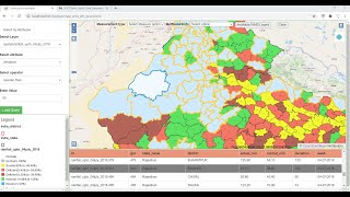
WebGIS application development using Openlayers 6 and Geoserver-part2 (Featureinfo and Measure Tool)

Вставка
- Опубліковано 6 лют 2025
- This video shows how to add getfeatureinfo and measurement tool in a simple Web GIS application using Geoserver, and latest Openlayers version 6
Link for the web GIS application html page:
drive.google.c...
Link for the jquery js file:
drive.google.c...
Link for downloading Openlayers 6:
openlayers.org...
Link for downloading layerswitcher
github.com/wal...
Link for video showing how to install geoserver with tomcat:
• Install Geoserver with...
Link for video showing how to Install postgresql with postgis extension and import/export shapefiles from the postgis database
• Install postgresql wit...
How to Publish shapefiles/raster images using GeoServer
• How to Publish shapefi...


Thank you very much for the second tutorial
thank you very much Mr Karan . I can add background like google satellite!!!
Hi I am not getting feature info popup for raster layer can you please solve this problem
Hello sir, activate get info is not working in my device, I think there must be any prerequisite for getting info from database, please help me that from which shapefile you are getting info, I have India state and India district shapefiles but still not working.
I have facing the problem in GetFeatureinfo, popup not showing. It gives the error in console - "Uncaught TypeError: helpTooltipElement is undefined".
How to resolve the problem plz reply.
Thanks
Please tell how to resolve the problem
Hello sir,the getinfo popup is not showing yet the function is the way you wrote. What could be the problem?
same problem here. have you fixed it already?
@@tsikinsLivestreams same problem i am also facing
same problem i am also facing
How can I share a web map with a client??? I have watched both of your videos I have created a web map but only I can access it how I can share it with a client?? Your response will be highly appriciated
You need to buy public ip address or you can buy private server space and install your application in that machine then you will be able to show your application to anyone
@@OpenGeoLab Can you make a video tutorial on that?? If someone has a server how can we upload a map on that?
How can I contact you?? can you share your WhatsApp number???
@@OpenGeoLab I have a server and public IP how can I install my application on it?
helptooltip is undefined error coming ....Pls help
yes i am also facing...plz tell how to resolve the problem
hi good afternoon nice video to learn the things , i am getting error Uncaught TypeError: ol.control.LayerSwitcher is not a constructor, could you plz help me with that! Your response will be highly appreciated
I will make a full video on how to develop this webgis from scratch soon (from downloading libraries to installing software ....with full setup)
@@OpenGeoLab thank you sir
Your efforts are remarkable. I have sent you an email, please respond. thanks