Younger Dryas Ground Zero

Вставка
- Опубліковано 28 вер 2024
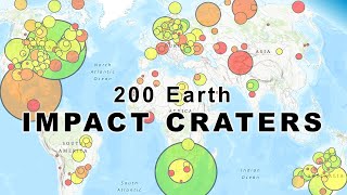
- The Carolina Bays and the Nebraska Rainwater Basins are elliptical features oriented toward the Great Lakes. Their convergence point is a clue about the location of an extraterrestrial impact on the Laurentide Ice sheet that launched pieces of glacier ice in ballistic trajectories. The secondary impacts of the ice boulders created inclined conical cavities that became shallow elliptical bays by viscous relaxation.
The Neglected Carolina Bays: Ubiquitous Geological Evidence of a Cataclysm.
Amazon: amzn.to/3uTRDsZ
Carolina Bay Survey. LiDAR Visualization Tool using Google Earth by Michael Davias. cbaysurvey.cint...
Python programs for least squares fitting of ellipses.
github.com/cit...


The existing evidence strongly supports the impact of several chunks of a recently desintegrated comet, still flying in close formation. The desintegrated comet theory doesn't only explain why there is not one single convergence point. It also explains why there is no distinct crater. The impact energy was spread over a wider area and over at least several seconds, if not minutes.
Must have been one hell of a firework. Within the range of the ice boulders, nothing bigger than an insect survived.
Could've been hours between impacts I read somewhere.
This also fits perfectly with the extinction of the Clovis culture. It’s always been known that they went extinct or vanished around this time but no one could find anything that would account for it. This perfectly dovetails with all the archaeological research. Best Regards and Best Wishes!
That Lake Huron bathmetery map made me even more convinced about this. The shock patterns, the deepest point alignment with Saganaw bay... It just smacks you on the face as self evident. If indeed this is the case the impactor must have traveled at such a low angle that its flight through the atmosphere was quite long which in and of itself must have deposited a lot of enegry even before impact. Very interesting and thought provoking.
Haiku inspired by YD.
Man kind spreads its wings-
Cosmic serpent flicks its toung-
World ends for MOST things.
Here is an epic poem inspired by the Younger Dryas: ua-cam.com/video/KmsR8h4qZRE/v-deo.html
Thank you for posting another interesting presentation.
I was also thinking that the "Ahnighito" fragment" that was found on Meteorite Island, Cape York Greenland, on the surface of the ground. It weighed in at 58,200Kg (second heaviest to be moved by people). Based on the weight and circumstance of discovery (no crater) led me to postulate that it hit the Ice Sheet there, cratering it, but not deep enough to reach bedrock. Also happened at the same general time as the Younger Dryas event.
The meteorite is likely a fragment of an asteroid that was less than 100 tonnes. This impact or airburst would have no noticeable effect on the climate.
@@blobrana8515 but the point made is about it not leaving an impact crater.
@@Alarix246 an impact crater is missing so is any tektites or iridium traces or spherules in ice cores etc or any other indicators that a large impact occurred.
(But what we could assume is that there were indeed small impacts that would leave small traces in sediment or ice layers)
The lack of a crater for some very heavy iron meteorites has baffled me. Look at the Hoba meteorite in South Africa. Its basically at ground level. Several very large irons in South America were not very deep. They must have decelerated all the way to terminal velocity, still I would think something that heavy should leave be buried deeper.
@@barthchris1 indeed it seems counter to common sense, but meteors can explode during atmospheric entry and not all meteors are travelling at super high speeds relative to the earth. (Some may actually be catch up with the earth in its orbit, and just like a car overtaking your car on a motorway the relative speeds are quite slow.)
So some large meteorites don't make large craters.
Great job at correlating the data. The maps help to visualize what you are talking about. Without visual aids, the mass of data would be overwhelming and unrelatable for the average listener. I have been looking for a video that presents hard data to support this impact theory. Thanks for making this.
I salute you, sir, for your exquisite research! I’m sold! 🙂
Wow, this is reallly compelling. I hope it can eventually be proven, because what an amazing discovery of such an immense cataclysm!
"Wow, this is reallly compelling. I hope it can eventually be proven, because what an amazing discovery of such an immense cataclysm!"
Hypotheses aren't 'Proven'. Science disproves bad hypotheses.
Observations are made. Mechanisms are proposed. Experiments are performed. A good theory is a synthesis that makes predictions.
I find the Glacier Ice Impact Hypothesis to be the most compelling, by far.
Is this the first time that anybody thought about including the earth rotation in the trajectory calculation?
I really don't get why this is still considered fringe. This is how Alfred Wegener must have felt when they all laughed at his plate tectonics theory.
The UA-cam algorithm definitely things it's fringe. Whenever I look at Younger Dryas videos, it's start recommending videos about past alien visits and lost advanced civilizations. 🙂
"... This is how Alfred Wegener must have felt when they all laughed at his plate tectonics theory."
The reason Wegner's hypothesis was panned was he couldn't propose the mechanism, i.e. Plate Tectonics. That continents could somehow "plow" their way - across - the sea floor made his proposal untenable.
I agree with you 100% except I think it hit in the Saginaw Valley. I am from Pittsburgh originally but live near Flint. Let me tell you. There is SO MUCH IRON in the ground here it's CRAZY. It turns EVERYTHING orange and is just nasty. I'm not talking about the Flint drinking water either. That's something completely different. I would like to talk some more because I have soil samples that I've analyzed and I'd like to discuss it with you.
Just hopping to this. I’m intrigued by the ice sheet impact hypothesis. I have read two arguments for thermokarst lakes. I reckoned that with an impact there should be overlapping bays, though thermokarst lakes from different periods could also overlap. Good the see overlapping bays get some attention.
Here is a video about overlapping bays: ua-cam.com/video/x6ZRJbE-klE/v-deo.html
That makes sense. Years ago my uncle and I were off roading in the upper peninsula of Michigan. One thing I noticed and asked my uncle about was why there were so many small circular ponds hidden among the trees? He of course wouldn't have known, but I think it is pock marks from icy impact crators like those found on the Carolina coastline. Very interesting stuff.
I live and work among the Carolina bays,your explanations are the most likely explanation for this phenomenon.
Woe to those who lived under the ejecta ,the there's no way man or animal could have survived. Here the bays are closely spaced and sometimes overlap.
You may want to download the Visualization tool for Google Earth to get LiDAR images of your location: cbaysurvey.cintos.org/
remember that for these longer distances of airborn pieces, you wouldn't draw a straight trajectory line, it would be a slightly curved line from the earth spinning underneath the object as atmospheric drag is slowing the airborn pieces. The more North/South these lines are, the more they would be curved
The Coriolis Effect doesn't depend on "atmospheric drag." The Glacier Ice ejecta followed ballistic trajectories through the vacuum of space.
Very interesting! Thank you for your diligence! And all the hard work that goes into such an excellent report.
Considering your meticulous analysis of the research available I can not see how any reasonable person could categorically deny the possibility of the ice sheet impact hypothesis. The preponderance of evidence supports it.
So, you’re saying that you don’t think they’re fish nests?
The dearth of other reasonable ideas goes a long way for me, too.
As a scientist, I have not dismissed the idea of fish nests. I am still waiting to find the skeleton of a 500-meter fish.
Well if you live in America, 95% OF citizens willingly ignorant, and still have caught onto 9/11, and many other things "they" have done......WEAK FOOLISH SLAVES.....LOOK AT UR DRIVER'S LICENSE, S.S CARD, BILLS, BIRTH CERTIFICATE, CAR TITLE, HOUSE DEED, SO ON. WHY IS THE NAME IN ALL CAPS?????? LOOK INTO IT
Those chunks of ice had to have been thrown high enough to almost be suborbital. It would have most certainly been a bad day to be any where around the area’s effected.
The fact that academics are so hostile towards the possibility without explaining why is reason enough to be suspicious of them
I love this! Shaws' theory and Mr. Randall Carlson are right on point with this presentation. I live in S.E. Michigan. It's facinating to find evidence of a multi-impactor scenario. Mr. Carlson theorizes something similar to Shoemaker / Levy 9 Jupiter impact, but on a smaller scale. Really good data presented here. Continued success.
So grateful for this important and interesting update 👋🏽👋🏽👋🏽
Data from multiple sources correlating with your own findings? That's the way to convince skeptics and newcomers. Bonus for me: I read Graham Hancock's "Lost Civs" book - and just learned that you submitted some of the data. The sound we hear is the collapse of ancient history as we know it... Excellent presentation. Thanks!
The impact origin of the Carolina Bays by oblique impacts of glacier ice is a new idea for which there are no other sources. Fortunately, I can demonstrate that well-preserved Carolina Bays are elliptical conic sections using the least squares method. So the math is on my side. There is nothing but handwaving for the eolian/lacustrine hypothesis.
Carolina bays have always interested me. Many larger ones are still in plain view; smaller ones have filled in. Walking through open ground in my native SC and NC, it has always been exciting to me to suddenly realize I am walking thorough one.
Once in McCormick County, SC, in an area where Georgia Pacific had harvested several dozen of acres of pine trees, they left debris of small limbs and undergrowth, the "crescent moon" shape jumped out at me. I had walked through this area for years, threading between pine trees, to get to a fishing spot. There was an old visible but filled in bay.
Amazing. I did not know then the true history and significance of this place.
Something melted several kilometers of ice across North American in a extremely short amount of time killing off the Clovis people and the mammoths leaving little trace. The tremendous shockwave and over pressure would also be hard to notice to spite there devastating results on the biology.
agree how about thousands of smaller comet impact neatly distributed on glacier and land
@@al2207 Probably a tidaly disrupted comet like SL-9 with some fragments hitting Siberia and the Pacifica. There are mass kill sites of mammoths crushed and buried in Siberia that are as yet unexplained.
@@coolhand411luke6 i was thinking of aliens perfectly directed ice comet to end glacial age and erase most of aliens traces on earth
I have done a bit of hiking and camping in the Shawnee national forest. If you look at satellite imaging just southeast of the garden of the gods it most definitely appears that there is an overgrown impact crater.
I could be wrong but to me that appears to be more of an ancient volcano.
@@pixiendixie4211 Garden of the Gods is an uplifted ancient sandstone plateau, not volcanic.
@@pixiendixie4211 could absolutely be correct. This entire area is very odd given the location.
Very good Antonio. Lots of info derived from the geometry and physics.
The video on quantification also looks at the thermodynamics: ua-cam.com/video/BG1Y1kOoxjk/v-deo.html
very similar to Randal Carlsons observations. a compelling presentation.
I intrigued to see the trajectories around the Great Lakes regions. It is reminiscent of the “meteor theory” concerning the great Chicago Fire of 1871 where several spontaneous fires erupted across Illinois that same night, all with the same vector.
There were fires that night in Wisconsin and Michigan as well....
maybe the circles may be volcanic mud along the line like all over southern illinois at new madrid fault
Look up , The Des Plains Distrurbance.
There is an impact site in Wisconsin called The Rock Elm Disturbance, idk if that helps.
There is a circular formation to the East of Memphis TN. It is surrounded mostly by Grays Creek. It is around 5 miles in diameter. I have not seen an explanation for it as yet.
I am from Indiana and have found several dozen teardrop shaped Tektites. An impact happen at some point around Indiana.
There is a confirmed impact site at Kentland Crater in Indiana. Shatter cones and shocked quartz are present. To get Tektites, you need an impact which creates molten impact glass, so it would have to be unrelated to the Younger Dryas impact hypothesis being discussed here.
I live in Northwest part of US state Georgia. Our soils is red clay. Its about 2 feet deep. Below this layer is a 1 inch thick layer of compressed ash. Its jet black and very hard. This layeris everywhere around my house. Something created a biblical fire that burned everything then was quickly covered in a tidal wave of high iron content clay. Whatever did this was a huge calamity.
Mud flood. Edit. I’m in south west mich Here we can see the line of the ice cap. Deep rich top soil Yet ten miles north pure sand. Same elevation
A hole dug 15 feet deep Showed
Dark soil sand hard mud some gravel And 15 miles inland at 300 ft above sea level a small layer of sand brought by the lake then the top soil
A few miles north. No top soil just sand. Stone tools show predominately left handed Large scrapers axes and
Lots of Ohio churt Some flint points
Lack the notch which are thought to be
12000 yrs old.
Look up solar micronova and pole shift.
@@jvin248 it sucks the neanderthals and the australian megafauna got destroyed by the pole shift 42000 years ago, if that didnt happen wed prob still have them today
It is possible that if the bays were created by massive falls of ice the chunks of ice would have collided with each other in the air this would present as some of the bays landing with divergent trajectories. Accuracy would be improved by measuring the trajectory of onle the largest bays as they would have been diverged less due to greater mass.
Ice chunks from a single impact site would be divergent. hence would not be on course to collide. More likely the impactor broke into several chunks, like Shoemaker Levy 9 on Jupiter. Then there would be a few different impact sites within minutes of each other
@Antonio Something to consider. Were the axis of the earth not as present but about 23 degrees rotated such that the Laurentide ice sheet's centre point was the actual geographic north pole, this would not affect the eventual landing points but it could allow for a different axial rotation component such that the impact site would be adjusted accordingly. Speculation, I know, but interesting to theorize and calculate the actual impact site as some place such as Lake Manicouagan in Quebec or some other such as the recently discovered Hiawatha impact crater in Greenland. Do you have the figures that might reveal such a readjusted location?
I think that is an excellent question, good job
Great report, good science, well done!
I really enjoy watching your analysis and supporting maths. And, I am about 80% in agreement with your analysis. The only hanging question I have is that when we see results of craters caused by the level of energy you are suggesting, we see only circular craters. It's why the craters on the moon are all circular. I was actually surprised when I first saw the tests they do with high velocity impacts in the lab. Even at a 30° angle, a perfectly circular crater will form. The only time we see an ellipse is when it receives a glancing blow of almost 0°. I truly believe the cataclysm of the YD occurred, but I am not 100% convinced the Carolina Bays are showing this event. If we can figure out how it would create an elliptical crater at sub-orbital velocities, we would be able to say it has been solved.
I know you did experiments shooting metal balls into clay, and this did show an ellipse. But the dynamics of a large piece of ice hitting the earth at the speeds you mention are not the same. It is a LOT more dynamic. We need to look at the high velocity science being done in labs in order to see what we are dealing with. Unfortunately, they, as well as the craters on the moon, are showing non-elliptical craters.
Please keep up the awesome work! I think it can all be figured out, and we are the only ones doing this research. Mainstream science is not willing to take the risk and say things out of the norm. But the truth is bound to be found out there somewhere!
This is a good point. I believe the answer is that the bays were not formed directly by the primary impact(s), which as you say tends to be circular, but by 'stuff' from the ice sheet that was splashed by the primary impact which would give it's velocity a large horizontal component. Kind of like the splash when you jump in a mud puddle.
@@stivosaurus Agreed. Cosmically speaking these aren't "high velocity" events.
A significant observation is that the Carolina Bays and the Nebraska Rainwater Basins only occur on unconsolidated ground that could have been liquefied by the seismic vibrations of the secondary impacts. An oblique impact on a viscous surface creates an inclined penetration funnel, which is a conical cavity that doesn't destroy the projectile, whereas an impact on hard ground destroys the projectile causing an explosion that makes a hemispherical impact cavity.
@Antonio Zamora thanks for replying! If you know of any papers that talk about impacts on viscous surfaces, I'd love to read them! I have not yet come across any, but I'm excited to learn!
@@JohnJ469 any large mass ejected into space and returning to the surface is definitely going to be considered high velocity and extremely energetic. Antonio was comparing them in terms of megatons of TNT, so yeah, definitely high energy impacts!
Can we know how soil saturation at Carolina/Nebraska impact sites affected the size and shape of these features? if the soil was very wet or very dry?
OR...With the energies involved, would it make a difference?
If a hot rock drove thru an ice sheet, would there be a massive secondary explosion?
Or is it a one-shot deal?
Waaaaiiiittt ...so You're sayin it's not just the impact in North America that's important but when meteors hit it launched giant chunks of ice everywhere? Do I understand that right?
That is right. The ballistic sedimentation of the glacier ice boulders was a horrific hailstorm that killed the megafauna and the Clovis people from the Rocky Mountains to the East Coast of the United States.
@@Antonio_Zamora It makes sense to me considering the ice sheet was miles thick...it wouldn't just evaporate. We've all seen a slow motion cam of a bullet hitting something. Never thought about it in these terms...
@@Antonio_Zamora nice. Gunners mate USN '77-81
Ballistics and BIG bangs my bread and butter back then. Good analogy of magnifying a slow motion shot into strata shows ejected debris. Enlarged to a global scale..ice sheet pieces ejected could reach miles in actual shape. The pressure change so instantaneously would shatter matter. Good work 👍
There are multiple impact craters on N. America. One in NW Greenland is also a possible for the Younger Dryas Period. It could also explain the water eroded canyons deep in the Atlantic Ocean and the west coast of N. America.
The Greenland crater was originally thought to be a potential candidate for the Younger Dryas impact, but subsequent research showed that it is 58 million years old. news.climate.columbia.edu/2022/07/19/crater-beneath-greenland-glacier-is-58-million-years-older-than-previously-thought/#:~:text=A%20March%202022%20study%20used,million%20years%20ago%20(Ma).
Thank you what do you think caused all these underwater canyons?
@@Mudguaard They were not underwater when they were formed. Rapidly melting Ice Sheet water carved them as it filled the oceans.
@@Tango4N I agree but the west coast is thousands of feet deep where they end.
Well done. Keep it coming
Just off the cuff, after listening to this video.
A. 12000 years ago, was the rotation of earth slower or faster?
B. How much energy would have been absorbed by the ice itself when it impacted in the bay?
C. Working backwards from the bays impact energy, the energy required to launch a piece of ice in a suborbital trajectory from Michigan is insanely large..
A. Faster. Google says: the earth's rotation is continuously slowing 1.8ms per century. Probably not much difference only 12k years ago. 600 million years ago, a day was about 21 hours.
B. This was not caused by an impact. They are ancient lakes.
C. Irrelevant based on B.
Here is a video about quantification: ua-cam.com/video/BG1Y1kOoxjk/v-deo.html
@@Antonio_Zamora Thank you for that link. In that video, you answer an important question about the mechanism by which the ice survives it's suborbital journey.
sea levels 11,000 years ago was up to 28 meters lower than today - the u.s eastern seaboard was a hundred of kilometers further east than these bays are .. they would have been crater lakes before they were bays.
They aren't called Bays in relation to water, but rather for the Bay Trees which grow in the area of the first oval holes found.
Also the global sea-level increase was over 140 metres to present levels.
If that happened today we'd lose almost every major city.
A few commenters suggested some original comet / meteorite impact locations in Wisconsin . There may be a chance that the comet / meteorite broke up upon entering our atmosphere and hit in several spots. There's a location near Baraboo, Wisconsin called Devil's Lake State Park...and as I recall seeing a trail sign stating it was believed to have been a crater from impact that filled up with water. Another resource is UA-cam channel "Glacial Gold Hunter" who suggests that there was an area in Wisconsin that the glaciers skipped around and didn't cover...and the lack of glacial gold in that area he's prospected (and other's similar results with prospecting there) show that the gold just isn't in that area's streams. I don't know if these dots are connected to the same time frame as the Younger Dryas event. But it makes me wonder.
A thousand words cannot do justice to the event..😬....and the one remark on the oral telling of the Mississippi adjacent land turning icey during a time....😨
There were multiple 'ground zeroes' along this latitude, due to comet fragments and a rotating earth
Tons of these bays in northern Alaska/Canada pointing at me in Michigan. No one talks about them.
Don't confuse thermokarst lakes in Alaska with Carolina Bays. The Carolina Bays have a mathematically elliptical geometry. See this video: ua-cam.com/video/J08WVFawFB4/v-deo.html
@@Antonio_Zamora Right on, I understand now. Geology will help mankind figure out our past and prepare for the next episode or stop it.
Well that was pretty interesting. I wonder how much water vapor would have been thrown into the atmosphere by all that friction. That plus the melt water could be the cause of the great flood story that was passed down through the religions that followed. I gotta imagine that would cause torrential storms like the world has rarely seen.
This is fascinating - thank you!
There was a crater found in Louisiana not long ago dating back 11,000 years. Wonder if that's connected to the younger dryas.
I wish I had the mathematical tools to model the variations in trajectories due to a) the impact crater was almost certainly dozens of km in diameter; b) the asymmetry of impact crater due to almost certainly oblique impact angle; and c) the interaction of the ejecta curtain blasting up through the shock wave created in the atmosphere by incoming impactor. Your geometry has revealed a rich field of study for generations of researchers with supercomputers.
Here is an article that discusses the modeling: onlinelibrary.wiley.com/doi/full/10.1111/maps.12127
Does this impact have any relationship with the huge amounts of mineral deposits around Sudbury Ont. in Canada?
The Sudbury impact is believed to be much, much older (like a 1.8 bazillion years or so). A good question, though.
NO....those deposits are part of the pre-Cambrian continental crust that had since been eroded into a "plain". Thos are mineral deposits from the solidifying of the crust.
Would any ejecta falling off the coast would cause a Tsunami?
I have mentioned before that multiple ice boulder impacts on the Atlantic Ocean would have produced very rough seas, but not a unified wave as from an earthquake.
Asteroids? We don't need no stinking asteroids.......
Or badgers either, for that matter. 🐦🎶🌿
I think you meant stinking hemmeroids.
A reference to the movie UHF. 💟
Question is what formed the Great Lakes? if you squint your can see and ark? Which would look like Lake Michigan and Lake Huron. Would fit comet impact. I wonder what drill cores the area would show? Often impact site gets filled in over time? Also multiple strike are possible? As a comets tail is fragmented? So what formed the Great Lake?
Great Lakes origin is pretty well established and doesn't include impact structures (aside from, some argue, Saginaw Bay). The arc of islands across Huron and the west side of Michigan are the Niagara escarpment. Superior and Ontario are remnants of rift valleys; Erie and most of Michigan and Huron sit atop the limestone structure that creates the escarpment.
@@gnostix1 I would say when looking a the geological map there are strange features? Even possible impact over different time periods? I would agree that the northern most lakes would be rift structure? There too long and thin to be impact craters. The fact Reddit argues constantly about the shape of geological strata with the best know maps showing distinct provenance in oval shapes? Sort of reminds me impact the cased k2 boundary? The geology does have two closely overlapping Ovid structures? Which can happen form certain sedimentary layers? Post impact? If it was a giant impact it would have been massive? yucatan peninsula sinotes mark the outer edges of the 65 million years ago impact. Funny that on limestone too?
@@gnostix1 I would say when looking a the geological map there are strange features? Even possible impact over different time periods? I would agree that the northern most lakes would be rift structure? There too long and thin to be impact craters. The fact Reddit argues constantly about the shape of geological strata with the best know maps showing distinct provenance in oval shapes? Sort of reminds me impact the cased k2 boundary? The geology does have two closely overlapping Ovid structures? Which can happen form certain sedimentary layers? Post impact? If it was a giant impact it would have been massive? yucatan peninsula sinotes mark the outer edges of the 65 million years ago impact. Funny that on limestone too?
Alright well i guess i grew up in a 12,000 year old impact zone that started the last ice age. Michigan just got more interesting wtfff
Actually no the ice was already there and had started to recede north as the ice sheet disintegrated the Land Base began to lift do in part of the lack of the glacier's weight even though this is a interesting concept being offered it's not working for me, I believe that impact was in the Southeastern section of Hudson Bay and the tridectory of impact was from a more north orientation
Can you search for ejector impacts for the Greenland impact craters recently found on the western edge of Greenland
for the carolina bays? greenland is too far away and their orientations would be completely different.
@@brianjacob8728 I'm talking about the extraterrestrial impact craters in greenland, I'm sure they also should have made other impacts like the Carolina bays, towards Iceland
@@brianjacob8728 also the Roseau structure in Minnesota is at the same angle of impact as Saginaw bay
Hi Antonio,
I enjoyed your presentation. Your mapping looks to be pointing towards Devils Lake state park in Wisconsin.
Check out a book called roadside Geology of Wisconsin by professors Robert Dott and John Attig.
I will be buying your book!
One of those yellow line segments connects to Federalsburg, MD, which is near me.
Good work caveman 💪💪 Randall Carlson would love this video. Randall is also a caveman 💪💪
I don't know how youtube knew I would love this but I do, subbed. I think your channel has gotten a greenlgight from our AI overlords.
Could you do a video on the Sudbury and it's importance in the Great Lakes and Northern and eastern Michigan?
Excellent video! Does Randall Carslon and Graham Hancock know about this yet? I'm serious
Graham Hancock actually wrote a chapter about my research in his book "America Before". See the chapter "Cape Fear".
@@Antonio_Zamora I have that book! Thank you :)
Thank You. Makes sense now.
An asteroid flew by the earth today, 14 sep. 2024.. 110 feet wide, It was sailing along at 104,271 MPH. My point, at that speed, an impact could easily launch a lot of ice into the atmosphere.
Wikipedia currently lists the impact hypothesis as "discredited". Not that it is a great source, but I thought I'd mention it.
The gatekeeper of Wikipedia does not accept anything having to do with the impact origin of the Carolina Bays. Several years ago, I added one sentence saying that the bays were mathematically elliptical with a reference to my peer-reviewed publication, and within one week he removed my sentence and the reference.
One person has been editing Wikipedia for a bunch of years
Holy shit i’m just trying to imagine that occurring if you stood in the great plains somewhere and witnessed it 🤦♂️
You better cover your head! Some of those impacts reached as far as Kansas and Oklahoma.
That is cool. Ever read Donald Wesley Patton and his hypothesis of an astral visitor and the formation of present mountain ranges? Thank you for your thoughtful presentation.
Very good analysis.
Holy shit! I live right in that zone!
I know your mom
Great work, great video. Ty
I skimmed over this at work. Did I miss the mentioning of thr Middlesboro impact crater in southeast KY? Or did he not mention it. One of the lines comes close, but two far to the west. Its the only US city in a crater and the impact opened up the "Gateway to the West" Cumberland Gap. All of the surface soil in northeast TN is rocky impact debri and red clay.
Are the ballistic trajectory lines you present, geodesic curves? "On the Kinematic Probability of Terminal Ballistics with Initial Dispersion", Sept. 1970, by H.M.Hung and J.T.Wong might be helpful. Tools similar to Wolfram's Mathworld help to easily solve these problems including the shape and orientation of the bays.
Google Earth has a ruler tool that draws great circle trajectories. Now that more people are interested in the Carolina Bays perhaps more exact methods will be found for calculating the convergence point.
The ice sheet covered land that would go on to become Saginaw Bay. Saginaw Bay didn't exist yet. So obviously there was "no ice". It wasn't a bay, it was hilly land under glaciers. The bay was formed upon impact.
Loved it
6-9min - wow
How about hydrogen seeps? The ice comet explanation is worthy, however.
I had similar thoughts. The intersecting lines also seem to run parallel to the edges of the two ice sheets that converged around the Driftless Zone of the upper Mississippi. I wonder if there are geological explanations, but the impact idea is cool too. #TeamCook
Your ballistics equations are too simple, because they do not take into account the reduction of mass of the ice boulders as they travel through the atmosphere, friction effects and the variation in air density with altitude. Initially the ice boulders were probably very irregularly-shaped shards, and as they traveled through the atmosphere, they were eroded by atmospheric friction and were probably much smaller and spherical by the time of impact. What you need to do is a step-by step simulation through time. Maybe you could find a program that simulates rocket ballistics and adapt it, because rockets share the same characteristic of losing mass as they travel (from burning fuel). The main difference is rockets have thrust whereas the ice boulders received an initial impulse of energy which was then dissipated by atmospheric friction. The drag coefficient of the boulder would also decline as they change from an irregular to a spherical shape.
You make some interesting points. I wonder, though, just how much you can do with your suggested calculations because the ice boulders would have many, many different shapes and therefore would not lose mass equally.
Another thought I had was just how large would ejecta ice boulders be? From my understanding, most impact craters don't toss out boulders this large. The rock gets shattered into much smaller pieces, and since ice is less dense/hard it would seem to me that they would shatter even easier. Don't get me wrong, I agree with the impact hypothesis, but there are still some problems to resolve.
@@ronrothrock7116
My understanding is that when a meteorite hits the ground, there is a cone of compression formed immediately under the impact, but outwards from that cone, the ice and rock shatter and are pushed upward by the compressed cone. It is that mass around the immediate impact area that is ejected.
There would probably be a range of sizes of shattered ice fragments, and I expect only the largest ice fragments would survive the re-entry into the atmosphere and form Carolina bays.
I think it`s safe to assume that most of the shards of ice would have been ejected with similar initial speeds. It may be possible to guesstimate what percentage of the meteorite's kinetic energy was transferred to the ejected ice shards.
As to the shape, you could assume an initial index of sphericity and associate a drag coefficient to the value of the index, and that the shape would become increasingly spherical.
Once you have the model programmed, you would have to run thousands of simulations, varying the initial parameters, and ending up with a range of results. I expect that all of North America and perhaps beyond would have been bombarded with ice boulders, and they formed Carolina bays-type features only in areas where the geology was right.
When you consider that probably only the largest shards formed bays, and that traces of the bays are only visible today in a few areas of appropriate geology, then that implies that the mass of ice ejected into the atmosphere must have been enormous.
From the sizes of the Carolina Bays, most of the pieces of ice that were ejected and managed to survive re-entry measured from 20 to 200 meters in diameter. This is comparable to the size of icebergs. A recent model proposed that an impact on an ice sheet would just melt the ice, but I think the model was wrong. See this video: ua-cam.com/video/lFDbYpLymwY/v-deo.html
@@Antonio_Zamora I believe you have a valid argument here. Besides heat it takes time to melt any great amount of ice.
Also. Would you revisit the "bays" here in Haskell County Texas. While the shapes would point roughly to the Wisconsin area, if you draw a line through the bays here they line up with the Tulsa area "bay" pointing to the Saginaw Bay area.
Preposterous, obviously you've never seen a volcano blow
very interesting. TY.
The magnitude of the change in climate during these periods tells me our silly climate change panic is futile.
Any shocked quarts ?
When we say comet impact . What break up the comet ,our atmosphere wouldn't challenge a comet nucleus and .No mention of any shocked quartz
ua-cam.com/video/K434-CP0FEk/v-deo.html
Atmosphere plus kinetic impact on a 2 mile thick sheet of ice.
I wonder if that explains something. Growing up in East Moline Illinois, my Grandfather had to have a side of his house dug up because the cinder block walls were slowly caving in, then they when the dirt was out of the way they reinforced the walls.
Where I am going with this is I climbed down in the hole, being a kid... and found several pieces of obsidian. at about 8-10 feet depth. They were shiny and caught my eye. Asked my teacher at school what it was. But why was volcanic glass in the Midwest???
I am geologist living only about 30 miles north of Marlboro county and the bays...I had never paid much attention to the bays. Excellent presentation.
You may want to download the LiDAR visualization tool for Google Earth from Michael Davias' website. You will be amazed. cbaysurvey.cintos.org/
I've also seen these bay marks in the upper peninsula of michigan.
I have long doubted that Saginaw Bay was the impact point and that the actual impact location had to be quite a bit further west. But, the fact that there are some Carolina Bays alignment differ by a large enough amount that it makes it more likely that rather than a single impact there might well have been several fragments. Comet Shoemaker-Levy 9, I think, offers an example of how a comet can be broken up by a past encounter with a planet and then those fragments would result in multiple impact sites.
He mentioned exactly that in the video.
As the Laurentide Ice Sheet was estimated to be about a mile thick, 5,000'+, an impact crater wouldn't necessarily exist in terrestrial strata as it would be absorbed by the ice sheet. It is likely multiple impacts as atmospheric break-up is common or even gravitational break-up i.e. Schumacher Levy 9. The bays would result as would massive melting of the ice, heating of the atmosphere, and subsequent flooding through sea-level rising and rain from the vaporized ice. Sudden atmospheric pressure increases with shockwaves could have resulted in the mass extinction of North American megafauna in the process. Depending on the number and mass of the impactor(s), axial orientation could also be affected. IMO
@@helmski there is on the west coast down from Northern WA to the Columbia River. It’s pretty apparent even to untrained eyes if you drive up the gorge.
Randall Carlson points to a lot of this. He has a great video of this.
If you look at northern Africa it also looks like a massive flow of water washed out half the northern end of the continent.
@@helmski it was well studied by people pushing a specific timeline and story of history.
Just like people saying the first humans in America were the clovis culture, or that specific animals weren’t in Alaska even though we’ve found their skeletons.
There were people who dismissed the Younger dryas impact theory 100 years ago only to be proven wrong. There are people who have built careers and names off from theories and a story that when proved wrong they defend and ruin people’s careers for bucking the system, only to be proven right decades later.
The scab lands of washington state prove a massive floor happened and happen over a short period of time, not a leaking lake from missoula.
That theory has been proven incorrect
.. ..yes
@@danm8747yeah but the African wash look like it came from the Mediterranean and headed west (Southwest)
@@bartbullock9742 this is very true. This to me looks like a slosh back from earth crust displacement if that is a true happening
Interesting! Thank you for sharing with us!
I grew up in NC and live in Michigan now, so this is literally extra close to home for me.
It's a shame Melton and Shriver never knew about the Nebraska Rainwater Basins and for sure they didn't know about the very few Oklahoma and Texas Bays. I live in the Cimarron river valley, a few hundred feet from the river. I'm about 30 miles north of Oklahoma City. I know this should be the edge of the ejecta in this direction. The Cimarron river bed is very wide, slow moving, and meandering. The ancient river valley can be 30 or 40 miles wide and the river changed direction like waster droplets on a car window, sometimes doubling back on it's self or even crossing it's self...at least until the banks can be eroded, and logic restored to the rivers path. There are so few hard rocks in Oklahoma that I think I know each of them. SO this should be a good area to discover eroded basins! I have looked at that LIDAR map until I see it in my sleep! The rolling sand dunes here, frozen in place with a thin layer of vegetation, naturally makes the space between each dune look exactly like a non oriented basin, eroded by 12000 years. I suspect that some of the ice sheet floods most likely used the Cimarron to Arkansas to Mississippi to Gulf path to get off the plains and to the sea. The floods could have erased the secondary impacts in the river valleys almost as soon as they were made. I'm out of ides for finding anything new just out my front door. I'm slightly disabled...well, more than I 'd like. However, getting out to find things like these would be a good reason for the hassle, or motivation for the pain. I'd like to at least go see the Neb Basins. It'd be a big deal for me but at least it's possible. Thank you for the videos, Antonio...AND the books!
Eric Brown found a remarkable basin near Tulsa. ua-cam.com/video/-9jlP7N_cmA/v-deo.html
Now this is science. Outstanding. Does Randall Carlson know of your work? He should..
@@johnsdimarco Randall and I went with Graham Hancock to explore the Carolina Bays when Graham was researching his book America Before.
Can you imaging being around to witness that younger dryas cataclysm. Must of been crazy... All the civilisations that got wiped out all over the planet is crazy during that time period!
Oh wait, youll get to......prob this yr actually.
Wow! Very well done! It would be cool to see this animated and rendered into a reenactment video
Congratulations on your most popular video to date. This one really took off. Reaching so many people. Its crazy the dominant landform of the east coast could be neglected for so long by science
Thanks. The popularity of this video surprised me. Perhaps it was due to the title, but it could also be because it included some history and an explanation of the usefulness of the least squares method for fitting ellipses and determining the dimensions of an overlaid bay. By the way, how was the equinox in the Tulsa Basin?
this correlates with the formation of the eastern Washington scab lands and the columbia river gorge
Even though it is blatantly apparent that UA-cam is ghosting my comments, I will leave this for synchronicity to find its way, here's my comment: BINGO.
Good to see you are back with your interesting presentations on the impact upon the Laurentide ice sheet. You were the first to present this over 7 to 10 years or so ago. Persons living on the rim of the ice sheets have a unusual segment of hills and valleys left upon the land. Especially on the northeast USA geology relative to melting glaciers, blocking ice, turning into lakes which many times would break apart carving and flooding lands later becoming the hills and valleys adjacent to rivers.
Ignore the detractors. This is excellent work. The comet impact theory at the start of the younger dryas continues to gather support from Greenland ice cores, core samples in lake beds as far south as Mexico, melt water pulse in the ocean, etc. Skepticism is healthy, but when multiple lines of evidence converge on one theory, that theory rises to dominance.
Of course, the megafaunal extinction and the 1200-year cooling event can all be swept under the rug and we can take great pride in attributing the origin of the Carolina Bays and the Nebraska Rainwater Basins to wind and water mechanisms or even to an Omnipotent Creator. There is no need for an impact at all.
@@Antonio_Zamora Godzilla....is that you?
@@Antonio_Zamora There is so much currently under the rug!
Hi Tony, glad to see you "back in the saddle, again". Looking forward to more interesting and scientific analysis of this extraordinary event.
Antonio does a great job supporting his Claim. I always enjoy his research materials.
Unfortunately, too many academia have this set in stone idea that nothing happened, and Siberian Source Tribes ran down through the Alaskan Glacial Ice Sheet opening and ate everything in site. Boy oh boy, them people must have been awfully hungry.
Antonio though offers a great explanation of Event and Effects. Very compelling and the data shows a ton of splash damage. Thanks Antonio.
Please keep up your research. Thank you.
This is SO fascinating!!
Excellent Presentation.
I knew a little about the Bays in correlation to the Impact Theory but your technical breakdown ties the loose ends together.
Academic Hubris is mostly to blame here.
Heaven forbid The Lofty Towers could be wrong. They are experts and have some paper on the wall to prove it.
a Great Lakes impact might make some sense, they are a pretty rare formation of fresh water lakes in the world.
Especially around lake superior and the exposed Canadian shield where rare earth mineral deposits of iron nickel copper and rare earth elements occur with significance.