Cascadia Tsunami.mov

Вставка
- Опубліковано 13 лис 2012
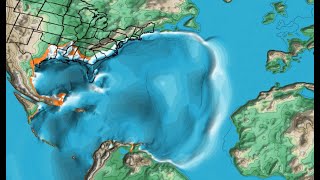
- This movie shows a physics-based computer simulation of the tsunami expected from the next Cascadia Earthquake. The last large Cascadia earthquake happened in January, 1700. It is thought that the fault is getting toward the final stages in the earthquake cycle and could break again at any time. The simulation suggests runups of as much as 10 meters could hit most adjacent shores within 30 minutes.
For more tsunami and natural hazard information visit es.ucsc.edu/~ward. - Наука та технологія


I live in Portland, Oregon, and have been just reading up on this. Excellent video. The Pacific Northwest is woefully prepared for this. An estimate of casualties for a serious event is 10,000 dead. This place is beautiful but due to the geologic activity it is also just a wee bit SCARY!!!
Thank you for this very informative video. I'm shocked that no one has left a comment.
After studying this cataclysm for decades - which includes living and researching in California for six years, British Columbia for two years and Washington state for 13 years, along with studying hundreds of historic documents, written in over a dozen languages from all across our Earth, and studying thousands of other independent sources, as a Doctoral Scholar with over 50 years of research, I can tell you that you - and the rest of the "scientific community" have this all wrong - I've known this for the past several years - and have reported this to you and hundreds of others for years - but you cling to your theories which will soon result in the deaths of billions of people.
I have walked in the ghost forest of the Copalis River and lived on the Washington coast for better than 50 years. I no longer live on the coast but I still have a emergency bug out bag and an emergency foot locker with supplies that can keep me alive in case of the big one.
Brian Garrow a little preparation goes a long way
The population who are on the coast and are standing from sealevel to 50 feet OR are at least one mile from the ocean at sea level would need to evacuate to higher ground. Other damage is collapsed bridges, mud slides and structure damage. The Cascadia subduction zone is of the same geographic construction as the Indian plate and Eurasian plate that caused the 2004 Indonesian tsunami.
lol "planners are hard at work"@3:40... but the emergency response pamphlet you pan through is for Santa Barbara CA :)
There are handwritten diaries by the Japanese that generallu described the tsunami as fatherless since no earthquake had happened there.
They are passed down to descendants who you can interview right now(obviously except when working or excreting).
@@daniellbondad6670 oddly specific
I love that we can literally tell exactly what time the earthquake happened because the Japanese were like "yo that was weird, better write this down"
Most of the actual evidence coming from government officials and people whose job it was to write things down (the Japanese had extensive record keeping at this time, also for insurance purposes) makes this statement look... "it's just chance that we found the diaries of some random Japanese peasants" is ridiculous.
if i lived in that ares i would get out asap.
This is an excellent visual
I don't understand these videos that opt for subtitles rather than audio. How are viewers to read and look at the video at the same time?
It would be interesting to see the effects of a rupture all the way down to Cape Mendocino, as the rupture on this simulation stops off of the CA/OR border, whereas the Cascadia Subduction Zone itself continues south to Cape Mendocino. The effects of this simulated Cascadia tsunami on the Eureka, CA area are shown at 2:34, but I do wonder how that might change in a situation where the rupture continued offshore of Eureka down to Cape Mendocino.
Eureka is the largest city along the Cascadia coast, and it is also one of the closest to the subduction interface. Eureka would also have less time between the earthquake and the arrival of the tsunami compared to other coastal locales, especially if the rupture starts at the southern end of the fault. Given that the area around the Mendocino Triple Junction is also one of the most seismically active places in the United States, it is quite possible that the next Cascadia megaquake could start at the southern end of the zone. In 1992, a series of earthquakes affected the Eureka area, the largest of which produced some of the strongest shaking ever recorded in California, and also generating a small tsunami that quickly arrived at the coast. Most notably, the 1992 quakes might have also ruptured a small section of the Cascadia subduction zone; had the Cascadia subduction zone been closer to the breaking point at that time, it would not surprise me if the 1992 earthquakes could have triggered a much larger rupture of the subduction zone.
In terms of the effects of the earthquake itself, I have also seen shaking simulations that show that a south-to-north rupture is the worst case scenario for the Seattle area (provided that the rupture continues all the way up to Washington state), due to what I would describe as the seismic waves "piling up" along the direction of the rupture. A north-to-south rupture starting off of Washington state is actually better for Seattle because the seismic waves will not have the opportunity to "pile up" as they would with a south-to-north rupture, but the shaking would be worse for places in southern Cascadia such as Medford, Eugene, Eureka (especially) and Redding should the rupture continue that far south.
Show the effects in the Seattle area please, every time it almost got there you moved the camera
Seattle will be soggy rubble. Most of it was built before this was known and is seismically deficient. When this pops, it will be a magnitude 9, and a lot (space needle?) will crumble. After that, the wave will add insult to injury.
I saw a writeup years ago that the south of Vancouver island would also shudder west about 18 feet, probably breaking down our more fragile buildings and infrastructure. As if that wouldn't be bad enough it was only a small side excursion in the cataclysm..
Why does the video always cut off the simulation just before reaching Seattle? That's the main reason people are interested in this and you leave it out? Makes little sense to leave it out!
+dattajack there's a separate video just for Seattle since it's built on land they expect to "liquify". Move inland to a higher elevation.
+brokenlibrary2591 Thank you.
+brokenlibrary2591 do you know where the video is located?
+mary chew --I saw it on regular television when I lived in the PacNW about eight years ago. No doubt someone has posted at least part of here on utube, you'll have to search it out.
Google "new/revised inundation maps/Oregon" if you have not already seen them, lots of people are in for some major wake up calls.
Maybe because it hasn't happened yet and they don't know what comes next
does this ingress of water take into affect the land dropping
Why do they build close to the shore???
I love it!
Good video. Think the folks there have more to be concerned about due to a 9.0 quake than the tsunami.
+Michael Yates LIving in Vancouver,BC we've been aware of this possibility for as long as I can remember...large at least in the southern region of the province tend to be rare,but often happen on the islands which are less populated...but we would definitely feel the Cascadia Quake if it hit because its a subduction quake which tend to run from Magnitude 8 and higher...many of our buildings have been built to new earthquake standards even some of the older ones like schools have been reinforced,though its probably the old brick building that will receive most of the damage,also Vancouver is almost an island surrounded by water so we have tons of bridges which I doubt will hold up to the quake an would literally cut us off...as to the tsunami Vancouver probably won't be major affected by that since we have Vancouver Island to protect us from the worst of that,but the island coastline is quite populated,our provincial capital Victoria sits right at the southern tip of the island at the Juan de Fuca Strait which also leads into Seattle,Washington,so everything on the west and south side of the island would be exposed to the tsunami(s)...the states of Washington and Oregon would also be badly effected,also the tsunami would travel down the coast...depending on the depth of the quake,shallower is a worse quake,but also magnitude,an 8 would cause a moderate tsunami toward shore,possibly 3-4 meters,a 9 would spawn tsunami of 6-8 meters,but anything above 9.0 say like 9.5 that hit Chile in the 1960's produced a tsunami that was able to travel across to Hawaii and Japan...it is presumed that the Cascadia quake of 1700 may have been as high as a magnitude 10 with the tsunami(s) large enough not only to wipe out the native villages along the various American/Canadian coastline but travelled all the way to Japan killing thousands there...most people living on Vancouver Island plus other islands exposed to the Pacific are aware of this danger and have tsunami evacuation routes planned out,warnings went out along the coast after the 2011 Japan quake but came to nothing except for small swells...I think the main problem will be that there hasn't been a major earthquake in BC in over 70 years let alone a subduction quake,most quakes in BC especially along the coast tend to run about Magnitude 4 or 5 with the occassional 6 or 7 which tends to happen on the islands and less populated areas without any major damage or loss of life,we had a 4.6 in December 2015 under Vancouver an only a few people felt it,where as we definitely felt the Seattle quake of 2001 which I believe was a 6.8...so its our lack of experience that could be our worst downfall.
1234lavallee1
I'm from vancouver too so i get the island defense from a tsunami. That confidence was shaken by the recent 4.9 in the strait, east of van island.
If it had been a 9.0, van would be hit hard by a tsunami
+The Time Of Revealing --the concern about this type of earthquake is that the tsunami it generates is "instant". We are so accustomed to Alaska or Japan generated tsunamis where we have warning buoys and time to take action. Cascadia is the twin fault to what happened in the Indian Ocean, I'm sure you remember that footage. Events of this type send ocean waves miles up rivers and on the open ocean the waves travel 400 miles an hour.
People on the coast don't stand a chance. Best bet, if you have hills behind your house, start climbing them the second you are able to.
brokenlibrary2591
Canadians would be hoping it occurs west of Vancouver Island, which would act as a shield. Very sparse population on west side of that island, so minimal deaths and damage. BUT, if it happens in the Strait, then I would call it a major disaster. Tsunami waves straight to the coast, where millions live.
+Michael
A 9 would not happen in the Straight though, it would occur out at sea, along the subduction zone.
I got family nearly at sea level in coos bay just across from the sand bar and the ocean.... thanks for video.. got to look and see if you did one for los angeles basin.
+Dave Greaves If they live 50-75 feet or higher then then sea level they should be okay.
I have friends there as well but about 16 miles inland up the Lower Coos River. I wonder what their fate would be?
I live 300 km from Vancouver anything bad gonna happen to me and what about Vancouver?
Wonder how badly Bellingham , Birch Bay, Blaine would be affected?
My daughter is in Bellingham. I think the low areas would definitely be inundated
Why do these diagrams not agree with the forecast inundation zone extending to Rt5? Or Ì5?
The projection for Richmond BC a suburb of Vancouver BC is the ground Wil turn to soup. 2.5m people call the Fraser valley home.
As someone who has family in Squamish at the end of Howe Sound, I do not appreciate how you cut off the video before the waves hit. Really unacceptable!
You're assuming one tint strip at the very edge of the plate is going to move, based on where the propagation point is. You are forgetting the subduction zone goes down into the plate at the area between the south tip of Vancouver Island, Seattle, Portland, Eugene, and then toward Eureka California. That whole section, and then out to the continental shelf where your propagation point is COULD potentially move. The ETS event and tremor reports on the PNSN site are showing 10,000 tremors in a 3 month period; from Vancouver Island to Petrolia, California.
Why else would Puget Sound Tribes have oral history of losing whole villages to the earthquakes (there were likely many aftershocks) and the Tsunami.
If you look at the Gorda Ridges, Gorda Escarpment, and Blanco Fracture Zone, you can see where the whole Juan de Fuca plate has shook back and forth. Right off of Oregon's Coast, at the base of the Continental Shelf you find north-south running ridges on the Pacific Plate. Those were made from an East to West shaking event. It's geologically the only puzzle piece that fits when you add in the Gorda Ridges. Go look on Google Earth, and then tell me I'm wrong. I think we are living in a far more dangerous spot than we realise.
Potentially, the crust could sink or divide right south of Puget Sound where I live in Centralia. I grew up hunting and fishing this area. I know it well too many of these mountains are young...much younger than science gives it credit for.
Go look at Mt Saint Helens, in the valley floor there. The erosion looks very old. Without testing it you would be hard pressed at just guessing how long ago it occured.
Have the mass of land along I-5 from Canada to Yrek California over to Ferndale or Petrolia California (Where I also used to lived and cycled many of those coastal roads and hills). Take the mass down 30 miles, and then to the edge of the Continental shelf.
Now run your tsunami scenario!
Interesting.
How big would the wave be when it hits Hawaii?
LIVE HERE NEVER HEARD OF THIS UNTIL NOW
first time for many things
It’s a shame you don’t simulate the Columbia river. There are many low laying areas in the Portland/Vancouver metropolitan area that would be inundated.
Cascadia fault along Pacific coast running down from Vancouver, BC, Canada , along Washington state and Oregon state all the way to northern California is expected to generate earthquake (9.2 or above) followed by gigantic tsunami. Avoid that region.
When are you going to do one on Moses parting the Red Sea?
And to think I left California for Washington's own version of the "big one"...
+barbaro267 Plate pressure also gives our mountains and snow melt out. Just live with it :)
Loren K It's hard to appreciate all that when everyone to the left of the 5 freeway is dead from a tsunami.
it just stoped all activity today wich is a sign of a big quake,i live in the area and its kinda scary
5 years later and nothing has happened. Don't worry so much :)
Mount St Helens needs to be factored in too.....as does inundation from aquifers now overfilled by ingress of seawater....
i live in Snohomish washington about 30 miles from the ocean should i get the hell out of here or is this part of washington safe
Please redo this video ASAP..it's time..we have about 30 moons left
This really need sound to be effective
The fortunate thing with Cascadia is that, like most subduction zones, the terrain is quite high relatively close to shore, meaning that loss of life could be minimized.
Have you ever visited Oregon beaches? LOL. It's a kill zone waiting to happen. You either have cliffs towering over beaches far below, where you have to climb a multitude of stairs back to the top, or a depression that splits the cliffs yielding to the beach, which will drive the incoming waves even higher when they reach those beaches. If it happens on a hot summer day in say July or August, there will be no way for people to escape. There are just old, narrow two lane roads into and out of those locations. The other problem will be the Columbia Bar where that huge ass river dumps about 7500 cubic meters per SECOND across the bar which is 3 miles wide at the mouth. The bar is where all the sediment is deposited so forms kind of like a dam at the mouth where it meets the ocean. When the mega-tsunami hits, and it will be mega, because the quake that causes it will be a mega in the 9.0 + range, none of that flow will be able to reach the ocean, and the tsunami will pile up the river flow and ride over the top of it across the sand bar up the river. Nobody really knows how far back it can push that flow, we've never seen it before. Portland is prolly safe because it's about 50 miles up river, but if you live in the low lying area say within the six miles of the bar, I feel sorry for you. If you live in Pu8get Sound, I feel even sorrier for you. That 10 mile wide channel open to the ocean will funnel that surge of water upward, even higher than the already 30 foot waves at the coast. Port Angeles on the WA side is toast when it happens. And the wraparound could very well deluge part of Victoria on the island. It's hard to say if it reach all the way to SEA because it will be deflected south by Whidbey Island first. But if there is enough backward flow thru the Strait of Juan de Fuca, SEA is going to get hit hard
Spiffy Turtle Thank you for the quite in depth knowledge. I used to live across the Tacoma bridge near Gig Harbor. That bridge is known to sway really hard. It's a suspention approximatly 1.6 miles and can carry up to 90-110 autos and trucks at full capacity.
Yes I have been to the beachs all up and down the coast. My greatest concern is for all the people who will not have any relief help or supplies possibly up to a week.
My next concern is for the other low areas such as Santa Cruz Caifornia and for Watsonville/Salinas valley where 10% of the food we eat comes from. And of course the possible breaking of the fault zones there.
May God be with us all.
1likeminded Main thing is not to be there when it happens. And with alla that discussed, we didn't even raise the very real probability that the cascade volcanoes will also wake up when the fault unzippers. They were erupting for a couple hundred years after the last great Cascadia quake in 1700
Spiffy Turtle You're right, Portland and the surroundings prolly safe from the Tsunami.. BUT Portland is not safe from the 9.0 Magnitude Earthquake
ilyas dzaky Portland is screwed cause that shaking from successive slow wake lateral movement will liquefy alla that ancient sediment and ashfall. Plus they have beaucoup un-reinforced masonry buildings not retro-fitted for that shaking. But they might not be immune to that tsunami either. If the tsunami backs up the Columbia enough, it could prevent the Willamette from dumping into the columbia fast enough and flood downtown Portland which has no floodwall protection for that kind of possibility in the lower development areas near OHSU
Does anyone know what would happen if the rockslides/landslides occur? More specifically what would happen if the tsunami waves propogated by the Cascadia 9.0 (+) earthquake met with the waves casused by a substantial rockslide/landslide which I assume would be directed in the opposite direction of the incoming waves to the NW of the US?
Would this by any chance reduce the impact of the Cascadia tsunami?
Someone knows if the tsunami can shock to Vancouver? Or there will happen just flooding?
Hi, I live in Victoria at about 800 m (497 miles) from the ocean (there is at least 5 houses between me and the ocean) and I would like to know if the tsunami could take home as in Japan?
Emojoy Charly Hi I live in Surrey, 50+ kilometres from the ocean. I am pretty high up
800 km or 800 meters?
Do ANY of these videos EVER show Alaska? 🤔
You keep showing BC and Vancouver Island but the closest you come to mentioning Canada is when you say Seattle!
It’s like anything above 49deg doesn’t exist as far as USA is concerned
legend
Wow, so about 2 minutes after the quake and the flood waters hit the coast...
The quake itself is expected to last 5-10 minutes, and almost immediately after the *intense* shaking the first wave will be hitting.
No time to evacuate, or even to get into your car...I’m afraid there will be a LOT of dead and missing people here when it happens (roughly every 250 years...and it’s been 320 as of now)
😳😵💀
How would this affect other parts of washington like spokane?
Refugees from the coastal cities like Seattle and Bellingham will be trying to get to Spokane for food/water/safety. I saw a video once online about it. Google Spokane + Cascadia earthquake.
Uhh. Dude Spokane is like hundreds of miles inland.
@@EmeraldBayMovies
...with a 4,000’ tall mountain range between the ocean and the “Inland Empire.”
3:23 It would shoot through the Juan de Fuca straight like a cannon.
Will the tsunami hit courtenay or comox? Its in Vancouver island ;-;
+A.Norwood no only coast line or near rivers that are at sea level
The east coast of the Island should be ok. I would be more worried about the ground liquefying and land slides.
A.Norwood 2004 study postulated that several towns and cities on the west coast of Vancouver Island, such as Tofino and Ucluelet, are at risk for a sudden, earthquake initiated, 1-2 m subsidence.[13]
The Cascadia subduction zone (also referred to as the Cascadia fault) is a convergent plate boundary that stretches from northern Vancouver Island to Northern California. It is a very long, sloping subduction zone where the Explorer, Juan de Fuca, and Gorda plates move from the west beneath the North American Plate, toward the east.
egathrust earthquakes are the most powerful earthquakes known to occur, and can exceed magnitude 9.0. They occur when enough energy (stress) has accumulated in the "locked" zone of the fault to cause a rupture known as a megathrust earthquake. The magnitude of a megathrust earthquake is proportional to length of the rupture along the fault. The Cascadia Subduction Zone, which forms the boundary between the Juan de Fuca and North American plates, is a very long sloping fault that stretches from mid-Vancouver Island to Northern California.[10]
Because of the great length of the fault, the Cascadia Subduction Zone is capable of producing very large earthquakes if rupture occurs along its entire length. Thermal and deformation studies indicate that the region 60 kilometers (about 40 miles) downdip (east) of the deformation front (where plate deformation begins) is fully locked (the plates do not move past each other). Further downdip, there is a transition from fully locked to aseismic sliding.[10]
You should still assume a tsunami of a few meters height even behind the protection of Vancouver Island. In the event of a large quake, get well above sea level until the all-clear is confirmed.
What about Nanaimo?
Sooo is this tsunami going to go all the way into the puget sound? Will.... say olympia get flooded?
+Smedley Butler >USGS has revised all their inundation maps, basically, never fall asleep at lower than 500 ft. When this event takes place, it will be an "instant" tsunami, no time to run for high ground. The PDF is available to print for yourself or to print and send to loved ones. Stay informed.
In this event, a tsunami in the Puget sound is likely not going to be bad. Really far down the sound will hardly be affected.
+Birdboy Birdboy it will be bad , water piled up in a narrow fiord, tends to build into a high wave, and remember the force and size of displaced water it will definitly be bad. it will probably be like the japan tsunami, wich was not a tal wall of water, but a fast rising stream of water.
+Thor Kipperberg the Puget sound is not narrow. Places like Seattle will not really be affected
Birdboy Birdboy
that depends on the direction and size of the slip, and the size and direction of the tsunami waves. Of course you are right when it comes to the puget sound its not narrow, but the juan de fuca strait, is wich is leading into the puget sound, and if the tsunami is directed in such away that it is headed in to the coast,in that area, all the water will be compressed into that narrow strait, and that will lead to a simmilar event that happen i japan, where the tsunami came in through a narrov bay with some islands around it, there was no big wave visible, but the water flowed quickly out of the bay area, and revealed lots of areas not usually visible, the water was then pushed back in by the tsunami, and the the tsunamiwave followed .It looked like a very fast rising tide, that went several meters over the norlam tidemark, flooding cities near the coast. My guestimate is that if the cascadia slips, and the juande fuca , is also affected, and the wave is heading straight to the coastline, a simmilar effect would happen in the puget sound. But who knows, baybe there will be no tsuanmi at all..
That's just assuming the quake is only a 9. It could be a 10, and that would devastate the west coast.
A magnitude 10 earthquake has never happened before. The odds of that happened are probably like 0.0000000000000000001%
this does not help me = i'm deaf and can't see the picture
I feel your pain bro, I have no arms and I’m blind as well..
No one even trains customer support. They always told my mom go online, I'd call them and tell them that's like telling a paraplegic to walk.
I live in Happy Valley, Oregon (Which is not too far from Portland) and we are about 70 miles from the Ocean. If the earthquake (9.0+) were to occur, how much would it damage our area?
***** Thanks for the helpful info, really appreciate it.
The tsunami would be 50-70 feet high when it hits the beaches.
If I understand it correctly, your greatest risk would be the tsunami coming up the Columbia River.
(oregonstate.edu/ua/ncs/archives/2015/feb/study-outlines-impact-tsunami-columbia-river)
RodsAndAxes Well I'm about 10+ miles from the Columbia River, would that still affect me?
"Any water level increases caused by a tsunami would be so slight as to be almost immeasurable around the Portland metropolitan area or Bonneville Dam, the study showed." You should be fine. Mount Hood is a greater risk to metropolitan Portland, albeit the city is not thought to be under existential threat.
Someone stole your video and saying that it's his
NO SOUND.....???????
2021 Dec 12th?
yo m8 im using your video for skol priject
+DEEZ NUTZ i wall creddit yu
do your own work lazy
He is. It's called research for a school project. Only time the research has to be completely original is if you're going for a PhD. You have to come up with your own stuff at that point ... but nothing inappropriate citing something like this as part of a paper on earthquakes or something like that.
I forgot to mention Oregon. Immanent warning.
I’d advise one of those big blow up balls you climb inside , that and a stick of dynamite.
Would it really be that bad to lose the left coast?
Yes Cliff , it would ' We have to insure that No Coast gets 'Left' Behind - Isn't that 'Right' ?
So beautiful, so full of such shit people. East coast isn't much better so far.
For those of us living on the left coast -- YES!!!
Why is there no sound it's boring without sound
How many volcano's are under control of the United Nations via the auspice of Heritage Foundations? Back in the late 90's, the UN was doing a global drive for control of mountains and catchment areas.
Again the curse of 26 like that of 666 omen
If you would like actual video (with music and narration if you like) I could try to provide you with some - ASK.
Ok Monica e everything still a
Ev en if this event waits another 150 years before it happens, it already shows us the utter incapacity of our society to make a meaningful response to a loss of the homes and production facilities for more than a 100 thousand families. Just housing, evacuating, burying, treating and relocating the victims would cost more than the Iraq war, and the losses on investment would do things we haven't known to the world economy. Worse, we'd have zero governmental/social/ideological capability to do much of what would be required. We're just not set up to 'care' like that. If the science is as rockhard as they're saying, it will soon be time to declare martial law and force the generation-long evac.
William, how about guv and corporations start acting responsible, like don't build in known fault areas for a start.
The Japanese could read and write, they kept accurate records.
?
I feel safe because all of the video shows Vancouver island protecting the metro Vancouver and Seattle area
Uhm...can't spell the word "traveled" correctly? I now find this hard to take seriously. People, please spell correctly or it becomes ridiculously invalid. You have 4 seconds to make a great first impression. You blew it, sorry.
Both traveled and travelled are acceptable. Traveled is the preferred spelling in the USA. Travelled is the preferred spelling in the UK or in the Commonwealth. By the way, you spelled “um” incorrectly. Your four seconds are up.
Like the FEMA director said "1.2 million people west of I-5 will be toast" his words and now we know why all those abandoned Walmart are becoming warehouses full of military equipment and supplies because when that monster is released and the issuing Tsunami my god it's going to be out of this world and it will take decades to rebuild.
1.2 million? Lol no just no. The total death toll estimates are 10k casualties at the highest. Also the director of FEMA didn't say that, a paleoseismologist at OSU said that and he was referring to structural earthquake damage, not human death.
O CAMON??????ANOTHER LIE AGAIN????
Hundreds of small quakes can constitute one large one... My faith is not in man but, I trust in our Heavenly Father...
Uhh, no thats literally not how it works.
Best sleep on HF’s boat.