🔴 URGENT TROPICAL UPDATE: Milton Reaches Category 5 Intensity Near The Yucatan...

Вставка
- Опубліковано 6 жов 2024
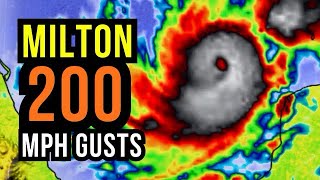
- Milton's remarkable rapid intensification is continuing. Satellite images show a small eye within the very cold central cloud cover, and the eye is becoming better defined. Data from the Mexican radar at Sabancuy show a small, closed eye with an intense eyewall presentation. The Hurricane Hunter aircraft earlier reported a peak
flight-level wind of 146 kt, and dropsonde data show that the pressure has fallen to around 933 mb, which is down about 22 mb in 4 hours. The initial wind speed is set to 135 kt, which is an 80-kt increase in 24 hours (only eclipsed by Wilma 2005 and Felix 2007 in our records).
www.tropicalti...
cyclonicwx.com
maps.weatherbe...
www.nhc.noaa.gov
www.weatherner...
www.ospo.noaa....
isotherm.rsmas...
zoom.earth
Checkout My Website:
www.sacramento...
/ @patspathpredictor
Subscriber Here For More Weather Content!!!!!
/ @weatherforce2024
Join this channel to get access to perks:
/ @weatherforce2024
Sacramento Weather Center Group:
Facebook Page: / 1344618369387132
WeatherForce Discord Server:
/ discord
Disclaimer: All of my videos and live streams are for entertainment purposes only, and to discuss raw operational model guidance and its ensembles, I'm also comparing models too. So please seek official sources like the National Weather Service, National Hurricane Center, or The Weather Channel for more detailed and accurate information.
My Social Media:
Facebook: / david.schlotthauer.77
Facebook Page: www.facebook.c...
Twitter: / weatherunited1
Instagram: / weatherforcedavid
TikTok: / weatherschlottdog1995
My Website: www.sacramento...
![[Monday] Milton Becomes a Cat 5 Hurricane; Major Impacts to Florida Expected Wednesday & Thursday](http://i.ytimg.com/vi/8HtnqOnj9tU/mqdefault.jpg)
![[Monday] Milton Becomes a Cat 5 Hurricane; Major Impacts to Florida Expected Wednesday & Thursday](/img/tr.png)