Hazard/Risk Consequence Analysis and modeling using ALOHA & ArcGIS

Вставка
- Опубліковано 29 жов 2021
- About ALOHA
ALOHA (Areal Locations of Hazardous Atmospheres) is a modeling program that estimates threat zones associated with hazardous chemical releases, including toxic gas clouds, fires, and explosions. A threat zone is an area where a hazard (such as toxicity) has exceeded a user-specified Level of Concern (LOC). ALOHA is part of the CAMEO® software suite of products for emergency responders and planners.
Key Program Features
Generates a variety of scenario-specific output, including threat zones, threat at specific locations, and source strength graphs.
Calculates how quickly chemicals are escaping from tanks, puddles (on both land and water), and gas pipelines-and predicts how those release rates change over time.
Models many release scenarios: toxic gas clouds, BLEVEs (Boiling Liquid Expanding Vapor Explosions), jet fires, vapor cloud explosions, pool fires, and flammable areas. See available scenarios by release source type...
Evaluates different types of hazard (depending on the release scenario): toxicity, flammability, thermal radiation, and overpressure.
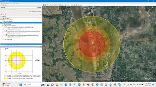
Displays threat zones on MARPLOT maps (and also on Esri's ArcMap with the ALOHA ArcMap Import Tool External link. and Google Maps and Google Earth using the export as KML feature).
I hope you will enjoy this tutorial.
#hazard_risk_modeling #consequence_analysis


one of the best UA-cam tutorial video I've seen!
Please sir, can you show us how to get the Aloha Software?
Sir please make a video upon AHP modelling on flood hazard zonetion.
Thank you for your suggestions. I have a plan to prepare a Flood hazard zonation map. Hope will upload soon. Thanks for your concern and for being with us.
Great video! I have a question on how to map the affected features (eg: commercial buildings) using ArcGIS to do some losses calculation? Thank you!
Thanks for this
You are welcome.
Thank you
You are welcome. Please keep in touch.
Very Help full video
Thank you 😊
Can I use it in mine area?
Good Afternoon Sir, Can I use this method for slope stability assessment ????
How to install ALOHA in Mac
Can you upload a video regarding hydrogeomorphological mapping
It is very good lecture(tutorial)
Thank you.
Can you please provide me with the links
Can you pls make a video on sesmic Microzonation
I would like to introduce(aded) the chimique gazoil into ALOHA
Could you please put video to learning how we can use aloha
Thanks for your idea. I will do it.
@@GISRSSolution Hello there, Can you implement code in omnet++ if I provide you the paper link?? give me ur mail pls
for a master's thesis at the university make me worth it?
yes, you can
Thank you
You are welcome. Please keep in touch. 😇