Hello, I did a curve number map for my catchment based on land use and soil types data of my country in polygon. Can I use that directly in the HRUs to simulate the runoff?
SWAT does not take curve number map. you have to use landuse and soil maps to create HRUs. I do not know whether it take polygons as input. I have always used rasters.
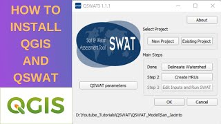
this playlist really well explained, thank you for the knowledge sir would you make another videos that contain all the preparation data process that used for QSWAT simulation? from 'data downloading' to 'input ready' for simulation. Thank you in advance
@@hydrologyvideos8253 will be looking forward to it! 💪💪☺ and also if you dont mind, can you do the same for the climate data? thank youuu very much sir! have a good day for you
@@hydrologyvideos8253 I request you to enlighten me about software and tools which are used for the following: Water distribution network(WDN), urban water management, drainage, waste water disposal, data acquisition, application of IOT to WDN.


![Lp. Сердце Вселенной #60 РОЖДЕНИЕ ЛОЛОЛОШКИ [Финал] • Майнкрафт](http://i.ytimg.com/vi/YoR0pAV9FVQ/mqdefault.jpg)


You have a very creative way of simplifying concepts which makes it easier for the others to understand. Good work!
Thanks for such a detail video.
damn bro such a niche topic and wonderfully explained
you are the best '
Thank you sir for wonderful videos
amazing!
sir please tell me that how the lateral flow ground flow precipitation and other in the diagram of swat checker are associated
can i use macbook to run Qswat? please help me answer, and guide how to run
I do use macbook so I do not know.
Hello, I did a curve number map for my catchment based on land use and soil types data of my country in polygon. Can I use that directly in the HRUs to simulate the runoff?
SWAT does not take curve number map. you have to use landuse and soil maps to create HRUs. I do not know whether it take polygons as input. I have always used rasters.
@@hydrologyvideos8253 Many thanks for your reply. The default curve number values can be changed for each HRU?
this playlist really well explained, thank you for the knowledge sir
would you make another videos that contain all the preparation data process that used for QSWAT simulation? from 'data downloading' to 'input ready' for simulation. Thank you in advance
There will be playlist for CN grid that explains the data processing for soil and land use.
@@hydrologyvideos8253 will be looking forward to it! 💪💪☺
and also if you dont mind, can you do the same for the climate data? thank youuu very much sir! have a good day for you
Sir, when will be the 2nd part
it is already uploaded: ua-cam.com/video/K6HFNo525EA/v-deo.html
how to contact you sir??
you can ask questions/post comments here!
@@hydrologyvideos8253 I request you to enlighten me about software and tools which are used for the following: Water distribution network(WDN), urban water management, drainage, waste water disposal, data acquisition, application of IOT to WDN.
@@gunngunn6763 unfortunately I do not work with WDN so I do not have anything to share with you!
@@gunngunn6763 epanet and epa swmm could be a good start
Hello I need some one expert in SWAT modelling
Clark Edward Lewis Angela Miller Nancy