Surveying and Staking points with Idig GPS Spotman

Вставка
- Опубліковано 12 чер 2024
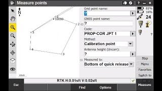
- Part 1 on my series of Idig's new 3D GPS system. I show how to survey an area, some basic CAD functions that can be carried out in the Ipoint software, and how to stakeout points.
- Авто та транспорт


Thanks for taking time to make this video Ollie. We appreciate your input 🙏
Very interesting Ollie, I have been using idig 2d for three years now and wouldn't be without it. Will look forward to your next videos.
Great to see what is possible, I am looking at getting this system next year. Just got the Touch system installed on my machines a few weeks ago and its pretty great.
Impressive Ollie. How much and will you be using it? Great video, look forward to the next installment!
Hi Ollie Nice one Have good week thanks again
Hello Ollie,
Really enjoy your videos! and would love to learn how to work excavator machinery, is there any way you could teach me?
Thanks,
Louie
I don't see you using a base rover. A US dealer that I inquired with states that you have to have a base rover or that you have to have a subscription on your phone to use as a base rover. Is this correct. How accurate is this without a base.
Its the same provlem for all gps for using them for somthing lime a kerb line you cant put the pins in at the top of all the droppers to the gps, the line will end up like a snake . But if you mark the 2 ends of the kerbline then pull a string and use that for the line and the gps for position its fine.
Good to see youve fot the new system from nasco are you fitting it to both your machines?