Thanks for video sir..sir if I would like analyze one dtm relative to another dtm as reference...and the result is a classify dtm every 1 meter above and below the reference dtm...how to do that?
I don' understand. When shapfile has been created, it doesn't look like the reclassified raster... How can I get a shapefile with the exactly the same classes of raster? thank you a lot...
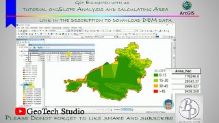
It reclassifies a raster band by assigning new class values based on the ranges specified in a fixed table. That is a comparison rules for the classification: the expression "min


thanks, heaps mate, I have been searching for a solution to my problem for ages nothing seemed to fix it. your method worked! cheers!
Thanks for video sir..sir if I would like analyze one dtm relative to another dtm as reference...and the result is a classify dtm every 1 meter above and below the reference dtm...how to do that?
I don' understand. When shapfile has been created, it doesn't look like the reclassified raster...
How can I get a shapefile with the exactly the same classes of raster?
thank you a lot...
you will have to polygonise
why the map turns orange after it is polygonized
By system, you have to categorize from symbology
why you used min
It reclassifies a raster band by assigning new class values based on the ranges specified in a fixed table. That is a comparison rules for the classification: the expression "min
How's the minimum and maximum value taken?
Checkout my latest video