OSINT Challenge: Airport Geolocation

Вставка
- Опубліковано 6 лют 2025
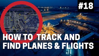
- This video provides you with an #OSINT challenge to solve. See if you can geolocate where I snapped this photo.
Instructions: Listen to the instructions and then pause the video at 1:30. Attempt to identify the latitude and longitude of where the attached image was taken. Once you've obtained the answer, or if you decide to give up, you may then unpause the video to see an example walkthrough on how to solve the challenge.
Original Image: raw.githubuser...


These are great. I will be teaching an OSINT college course this summer and would love to use your channel as a reference for students. Keep up the good work.
Thank you, and please feel free to! It is very exciting to see more colleges and universities offering OSINT courses as an option.
May I know what college do you teach?
Great video! More OSINT challenges please
Thanks! We do have some more that we are working on.
This was a great video. Thank you so much for sharing.
Thanks, glad you enjoyed it!
Wow, very enjoyable, thanks for this video
Glad you enjoyed it!
Great content mate!
Appreciate it!
Hi, nice challenge. I couldn't enhance the photo enough to see any of the details that you pointed out. Any ideas on how I could enhance the photo? Also thanks for the video.
Hey there, which details are you unable to see? There are no enhancement techniques used on the photo. If you click on the original photo link in the description you can zoom in on the photo by holding the Ctrl key and scrolling up on your mouse wheel.
@@OSINTDojo I was being a bit to eager. I missed the obvious.
Happens to the best of us!
I also missed that there was a separate link to the photo. Maybe worth mentioning in the voiceover?
Good call!
Noi Bai international airport (I snipped the zoomed in view of the airport and reverse image searched it on google)
Enjoyed this one very much! I was hitting my head against the wall trying to figure out the aircraft on the right side, but did not manage and realized I had spent way too much time chasing down that lead - as I was then quickly able to find the location solely based on the aircraft to the left... Could have been more effective, but learned a few lessons which is good for a n00bie such as me :D
Glad you enjoyed it!
💪🏾💪🏾💪🏾💪🏾
Good stuff
Appreciate it!
and if you use EXIF data from the image?
This image contains no EXIF data