
- 117
- 339 153
Geocarto
Приєднався 24 бер 2022
Welcome to Geocarto a channel dedicated to GIS, cartography and geoscience. Here you will find series of tutorials and tips that show you how to use various GIS software for spatial analysis and map making.
Subscribe to receive weekly tutorials!
Subscribe to receive weekly tutorials!
Get Free High Resolution Drone Image
Open Arial Map is a free website that allows you to download high resolution UAV images from all around the globe. This video is a step-by-step tutorial on how to download a drone image using this website.
Open Arial Map website:
openaerialmap.org/
Open Arial Map website:
openaerialmap.org/
Переглядів: 510
Відео


Get satellite image from Google Maps
Переглядів 3102 місяці тому
This video will show you how to extract a high-resolution Google Maps satellite image, then export it as a PNG. Google Map Customizer website: www.chengfolio.com/google_map_customizer

Get Free Global Soil Erosion Data
Переглядів 1292 місяці тому
European Soil erosion Data Centre website contains various datasets, in this tutorial we are going to use this website to download free Global Soil Erosion Data, this data of this website covers the whole planet. European Soil erosion Data Centre website: esdac.jrc.ec.europa.eu/

Get the Surface Water of any location
Переглядів 1222 місяці тому
Global Surface Water website contains various datasets, in this tutorial we are going to use this website to download free surface water data. This dataset covers the whole planet. Global Surface Water website: global-surface-water.appspot.com/

Get an image from Google Maps
Переглядів 2342 місяці тому
This video will show you how to extract a high-resolution Google Maps image, then export it as a PDF or as a JPG. Google My Maps: www.google.com/mymaps

Download satellite image using Google Earth Pro
Переглядів 7644 місяці тому
This video is a step-by-step tutorial on how to download a high-resolution satellite image of any place around the world using Google Earth Pro.
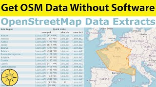
Extract OpenStreetMap Data Without Software
Переглядів 1834 місяці тому
In this tutorial we are going to use OpenStreetMap Data Extracts of the Geofabrik website to download free OpenStreetMap data of any place on earth. Then we are going to use ArcGIS Pro to show this data. Geofabrik website: download.geofabrik.de/

Download World Administrative Boundaries
Переглядів 1234 місяці тому
Quick tutorial on how to get World Administrative Boundaries of any county around the world as a shapefile for free. Opendatasoft website: public.opendatasoft.com/explore/dataset/world-administrative-boundaries/export/

Download Free Topography Data
Переглядів 2144 місяці тому
In this tutorial we are going to use the Open Topography website to download free topography data of any place on earth. Then we are going to use ArcGIS Pro to show this data. Open Topography website: opentopography.org/
Convert GPX to Shapefile using Global Mapper
Переглядів 1434 місяці тому
In this video we’re going to discover a simple but effective way to convert GPX to a Shapefile file using Global Mapper, the final Shapefile file can be used directly inside your GIS Software.
Extract OpenStreetMap Data to QGIS
Переглядів 1704 місяці тому
In this tutorial we are going to download OpenStreetMap data directly as an OSM file, then we are going to use QGIS to extract different features from this OSM file. OpenStreetMap website: www.openstreetmap.org/
How to Contribute to OpenStreetMap
Переглядів 2424 місяці тому
In this video we’re going to learn how to contribute to OpenStreetMap, the free and editable map of the world. OpenStreetMap website: www.openstreetmap.org/
Download OpenStreetMap Data without Software
Переглядів 994 місяці тому
In this tutorial we are going to use the OSM Download Tool of the Humanitarian OpenStreetMap Team website to download free OpenStreetMap data of any place on earth. Then we are going to use ArcGIS Pro to show this data. Humanitarian OpenStreetMap Team website: export.hotosm.org/v3/
Convert Excel to GPX using QGIS
Переглядів 4914 місяці тому
In this video we’re going to discover a simple but effective way to convert excel coordinates to a GPX file using QGIS, the final GPX file can be used directly inside your GPS.
Convert GPX to Shapefile using ArcGIS Pro
Переглядів 3354 місяці тому
In this video we’re going to discover a simple but effective way to convert a GPX file to a Shapefile file using a tool inside of ArcGIS Pro, the final Shapefile can be used in any GIS software.
Convert GPX to Shapefile using ArcGIS
Переглядів 2785 місяців тому
Convert GPX to Shapefile using ArcGIS
Georeferencing a Topographic Map in Google Earth
Переглядів 4725 місяців тому
Georeferencing a Topographic Map in Google Earth
Convert Excel to GPX using Online Converter
Переглядів 1,7 тис.5 місяців тому
Convert Excel to GPX using Online Converter
Convert Excel to GPX using Global Mapper
Переглядів 7615 місяців тому
Convert Excel to GPX using Global Mapper
Georeferencing a Geological Map in Google Earth
Переглядів 6575 місяців тому
Georeferencing a Geological Map in Google Earth
Create DEM in ArcGIS Pro using data from Google Earth
Переглядів 3276 місяців тому
Create DEM in ArcGIS Pro using data from Google Earth
Import Geological Map into Google Earth Pro
Переглядів 4806 місяців тому
Import Geological Map into Google Earth Pro
Georeferencing a Geological Map in ArcGIS Pro
Переглядів 1406 місяців тому
Georeferencing a Geological Map in ArcGIS Pro
Convert KMZ to Shapefile using ArcGIS
Переглядів 2766 місяців тому
Convert KMZ to Shapefile using ArcGIS
Make 3D geological Map in Google Earth Pro
Переглядів 6266 місяців тому
Make 3D geological Map in Google Earth Pro
Download Free GIS Data From Natural Earth
Переглядів 3796 місяців тому
Download Free GIS Data From Natural Earth
Thank you for a great tutorial. I should mention a GPX file, depending on which device or source it comes from can either be a TRACK or a ROUTE. Routes do not contain any time information, just pure coordinates. Routes will not show up in Google Earth, eventhough it will focus on the correct coordinates. If you are exporting from a GPS smartwatch app or some other device, make sure you export GPX as TRACK (or sometimes called "workout"), not "route".
Thank you. Needed this tutorial so bad :)
Very useful tutorial, thank you very much : D
thank you. it helps me a lot
thank you for this
Thanks for the updates its a good job, cogratulation bro
Excelente Explicación!!!
You just saved me 4 hours of my life! Thank you!😇
nice video brooooo.......
does not work anymore
Bhai tere vaha ke satelite ache h isi lie aisi image aai baki glooble maper kuch nahi kar sakta
Nice video. Thanks.
You teach amazing ❤❤❤
Thanks man❤
THANKS.This was really helpful. Can you please let me know if these single line labels are in mm?
Hi sr , how about from northing, easting convert to latitude and longitude
Thaaanks so much I spent over 5 hours scrambling around ArcGIS trying to find out how to do that! Big thanks to you !!!
Cool! Thanks for shaing it! What level of error (or precisión) is in this method with respect to using a Lidar photo?
Is wind speed data available for 2023?
Thank you very hepfull
Beautiful man , excellent work.
Good job. Thanks a lot.
Nice
you didt considered first time user, because the already built template will not be available to them as in my case.
Following your tutorial, I am trying to upload csv file with latitude and longitude into Google Earth Pro. But whenever I upload the csv file Google Earth Pro does not recognize the columns separately, it combines all the columns as one column. At the step select latitude and longitude field, it shows all the tittles as one. I have relooked at the csv file, separated it well with the headings under each column but still. Please can you help me upload this file?
thankssss
Amazing video ... thanks for sharing
Thank you!
hI - thx for video .. is there a possibility to creat an animated high profil also?
Simple & Straightforward Tut! Thank You!
Nice presentation,good job bro
This guy's accent is moroccan
thanks
Very Helpful
Helpful
thanks a lot !!
thank you so much
THANK YOU SO MUCH
Thanks for taking the time to make the video. Is there a way to select a point every x amount of distance in a given area instead of manually drawing them?
thank you brother for sharing us
*promosm*
will get rivers (india) shape files ?? please suggest me ; where ??
Please, my friend, I ask you about this browser, Global Paper. Is it free? How do I download it? Thank you
Global Mapper is a software and it is not free
Hello. Thanks for this tuto. But i am wondering if images on Africa precisely on West Africa have high resolution?
Not getting altitude option ! This isn't working.
thank you! this was very helpful. in case it is helpful for others, i first tried coordinate system IRENET95. however, when i ran the xy table to point tool, the dem showed up in my contents pane but nothing shows up on the map. i switched to default WGS_1984 and all went smoothly.
No longer works.
Same here! looks like the website is down! :(
super important and cool! in the Architecture's facoulties they don't teach how to do that so I need to say thank you for your work! well done<3
good job friends
You didn't add the basemap bro, did you know that it does not has proper CRS?