

- 111
- 109 804
Bad Elf
United States
Приєднався 1 бер 2012
Bad Elf, LLC envisions, designs, and manufactures niche hardware and software with an emphasis on Apple's MFi ("Made for iPhone/iPod/iPad") program. Bad Elf began developing handheld GNSS receiver accessories for the aviation and marine markets. As more and more GIS customers began adopting our products for mobile field collection, we have pivoted to a more GIS-centric operation. Our team spans the USA geographically and shares over a decade of shared work and personal history. The Bad Elf team mixes decades of experience and expertise in embedded hardware, firmware, middleware, and application software.
Getting Accurate Elevation Data with Bad Elf Flex | Best Settings for Field Maps & GIS
Ensuring precise elevation data with your Bad Elf Flex starts with the right configuration. In this tutorial, we walk you through the essential settings to achieve reliable orthometric heights in Field Maps and other third-party apps. Avoid common errors and optimize your setup from the start!
🔧 What You’ll Learn:
✔️ How to set the correct antenna and pole height for ground-level accuracy.
✔️ Why the 23 cm integrated antenna offset should remain enabled.
✔️ Choosing the right orthometric model (USGG2012, GEOID18) for your location.
✔️ Optimizing NMEA output for seamless data integration.
✔️ Important notifications and checks to verify pole height and app settings.
Make sure your surveying and GIS data is as accurate as possible!
📩 Have questions? Contact us: GET@BAD-ELF.COM
🛒 Shop Bad Elf GNSS Solutions: bad-elf.com/pages/buy
Bad Elf RTN MAP: bad-elf.com/pages/bad-elf-rtn-map?srsltid=AfmBOooxECv6XWJxwZThw5oLsjufBEiwA4FsL26CefgNZEiVDKE2PSww
Desert Botanical Garden Case Study: www.esri.com/en-us/lg/industry/conservation/stories/how-gis-gnss-helped-create-digital-twin-for-jewel-of-the-desert
Bad Elf Testimonials: storymaps.arcgis.com/stories/db312f3da2be420e873d7a6cebbc13af?srsltid=AfmBOoq0XMo8HGqAfhRAHoABQmx3bnKdQKL3CAS8nIz8B-3DLP3OYU8n
#Surveying #GIS #BadElfFlex #ElevationAccuracy #FieldMapping #Geospatial
Переглядів: 23
Відео


Pairing Bad Elf GNSS Receivers with Avenza Maps
Переглядів 116Місяць тому
Curious about using Avenza Maps for navigation or fieldwork? This video shows you how to pair your Bad Elf GNSS receiver for improved accuracy and more reliable results. Achieve better positioning to enhance your mapping workflows, so you can make more informed decisions in the field. What’s Inside: Why Pair with Bad Elf? Learn how professional-grade GNSS receivers boost accuracy over standard ...

How to Change GPS Provider for Location-Aware Apps: Easy Guide for iOS & Android
Переглядів 371Місяць тому
Looking for better GPS accuracy for mobile GIS apps and navigation apps like OnX Hunt, Google Maps, Waze, Avenza Maps, and Maps ? This video walks you through changing your GPS location provider on iOS and Android. Whether you’re navigating or doing professional fieldwork, we’ve got the tips you need to boost your precision! Here’s what we cover: 1️⃣ Why Upgrade Your GPS Provider? Get better ac...

Announcing The Bad Elf GNSS Surveyor Rebate Program
Переглядів 1312 місяці тому
2/7/2025: This program has ended but there are options to upgrade your legacy Bad Elf Devices. Please contact support@bad-elf.com. This video introduces the advantages of upgrading from the Bad Elf GNSS Surveyor to the powerful Bad Elf Flex Mini Extreme. Designed with precision, reliability, and flexibility in mind, the Flex Mini Extreme is packed with features that enhance GNSS performance, du...

Bad Elf at ESRI UC 2024!
Переглядів 1526 місяців тому
Bad Elf at Esri User Conference 2024! Join us as we showcase the latest GPS and GIS technology at the biggest geospatial event of the year. Learn how Bad Elf solutions can enhance your field work, data collection, and mapping projects. Discover our new products, attend our workshops, and connect with our experts. #BadElf #EsriUC #GIS #GPS #Geospatial #Fieldwork #Mapping #Technology #innovation ...

Elevate Your GIS! Elevation Datums for Orthometric Heights
Переглядів 4786 місяців тому
In this video, we dive into the basics of elevation calculations, exploring the concepts of ellipsoids, geoids, vertical datums, and orthometric height. We'll also discuss key reference systems like NAD83 (NAVD88) and WGS84 (EGM). Whether you're in surveying, construction, or just curious about how elevation is measured, this video is for you! #geospatial #Elevation #Surveying #Geodesy #NAD83 #...
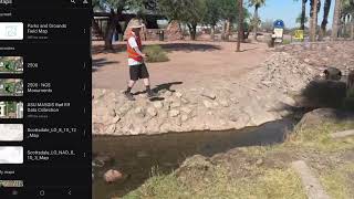
Parks and Grounds Management with Bad Elf
Переглядів 1847 місяців тому
Managing parks and grounds assets? Watch us talk through best practices when it comes to using GPS receivers like the Bad Elf Flex Mini to map and locate features. 👉 Looking to get your own Bad Elf Flex or Flex Mini? If so, click here to get to our store: bad-elf.com/pages/buy VIDEO TO WATCH NEXT: How to Stake Out a Known Point: ua-cam.com/video/L_Y_rsGNQ-8/v-deo.htmlsi=C1Y1U6KVi5cEpKkw #HowToG...

Land Surveying with the Bad Elf Flex
Переглядів 3157 місяців тому
Check out these clips on tackling land surveying projects and how the Bad Elf Flex can help. Topo Map Guide: ua-cam.com/video/onN3Q49RSyM/v-deo.html 👉 Looking to get your own Bad Elf Flex or Flex Mini? If so, click here to get to our store: bad-elf.com/pages/buy VIDEO TO WATCH NEXT: How to Stake Out a Known Point: ua-cam.com/video/L_Y_rsGNQ-8/v-deo.htmlsi=C1Y1U6KVi5cEpKkw #HowToGPSMapping #Stak...

Avoid Datum Transformation Errors! How to Use Custom Basemaps With ArcGIS Online and Field Maps
Переглядів 4028 місяців тому
Datums and projections can be tricky! If your organization's field collection points are offset by a few feet from other points or the basemap, the culprit is almost certainly your datum transformation. There can be several causes of this, but we're here to walk you through a single simple solution. By uploading a raster tile layer to your ArcGIS Online organization, you not only avoid datum tr...
GPS Stake Out, Contours, Ground Control Points for Drone Imagery | GPS Mapping Guide
Переглядів 1,7 тис.10 місяців тому
GPS Stake Out, Contours, Ground Control Points for Drone Imagery | GPS Mapping Guide
Topo Map Guide with Bad Elf and AutoCAD! #badelf #gnss #survey
Переглядів 11610 місяців тому
Topo Map Guide with Bad Elf and AutoCAD! #badelf #gnss #survey
How to Stakeout a Known Point - Guide to NGS Monuments
Переглядів 95311 місяців тому
How to Stakeout a Known Point - Guide to NGS Monuments
How To Map Topography with GPS and ArcGIS Field Maps: Sewell Park & The San Marcos River
Переглядів 664Рік тому
How To Map Topography with GPS and ArcGIS Field Maps: Sewell Park & The San Marcos River
ArcGIS Online Guide: Preparing For GPS Data Collection and Topographic Survey
Переглядів 1,1 тис.Рік тому
ArcGIS Online Guide: Preparing For GPS Data Collection and Topographic Survey
Manage Road Signs Like a Pro with ArcGIS Sign Management
Переглядів 855Рік тому
Manage Road Signs Like a Pro with ArcGIS Sign Management
Can Your GPS Do This? Bad Elf Flex Mini + Apglos Survey Wizard for Easy Land Survey!
Переглядів 1,8 тис.Рік тому
Can Your GPS Do This? Bad Elf Flex Mini Apglos Survey Wizard for Easy Land Survey!
Bad Elf Flex Mini How-To: Mobile App Overview
Переглядів 1,3 тис.Рік тому
Bad Elf Flex Mini How-To: Mobile App Overview
Attaching the Universal Paddle Mount to your Device - Bad Elf Flex Mini How-To
Переглядів 884Рік тому
Attaching the Universal Paddle Mount to your Device - Bad Elf Flex Mini How-To
Tree Management with Bad Elf and ArcGIS Solutions
Переглядів 232Рік тому
Tree Management with Bad Elf and ArcGIS Solutions
Bad Elf Flex Mini: Collecting Your First Point
Переглядів 2 тис.Рік тому
Bad Elf Flex Mini: Collecting Your First Point
Apglos Survey Wizard and the Bad Elf Flex
Переглядів 132Рік тому
Apglos Survey Wizard and the Bad Elf Flex
Master Laser Offsets with the Bad Elf Flex: Beginner's Guide
Переглядів 206Рік тому
Master Laser Offsets with the Bad Elf Flex: Beginner's Guide
Mapping the Old Mill: Using GPS to Explore Local History
Переглядів 196Рік тому
Mapping the Old Mill: Using GPS to Explore Local History
Learning Base and Rover 101 with Chris The Bad Elf
Переглядів 245Рік тому
Learning Base and Rover 101 with Chris The Bad Elf
Uploading Projected Vector Tiles Layers as Basemaps for ArcGIS Online Field Maps
Переглядів 1,8 тис.Рік тому
Uploading Projected Vector Tiles Layers as Basemaps for ArcGIS Online Field Maps
UAS Reviewed: Getting Control of Ground Control
Переглядів 52Рік тому
UAS Reviewed: Getting Control of Ground Control
Can you clarify. Once you located the starting pin, and save that point into your GPS unit (which model exactly?). How do you navigate to the next pint per the deed? If the next point is 200.45ft North 2.34 degrees. Do you program in 200.45ft N2.34 or do you need to do Lat and long calculations and program that into GPS unit? Or is there software on your phone tied to GPS you input the next leg to navigate to?
Neat!
Thanks @dave
Amazing! Good Job!
Simple and informative; good video Chris. Thanks!
Nice music 🎵
Thanks for the breakdown! Could you help me with something unrelated: I have a SafePal wallet with USDT, and I have the seed phrase. (alarm fetch churn bridge exercise tape speak race clerk couch crater letter). How can I transfer them to Binance?
Thanks @noah!
so.... you guys mentioned some sort of "iOs Survey Wizard" app. You're not talking about the Flex app, so can you shed some more light on that app?
We are happy to provide more detail. Apglos Survey Wizard is an easy-to-use land surveying application for Android and iOS. We partnered with them last year to help provide a simplified field mapping solution for our users.
Awesome product.. I've been following BadElf development and quite amazed you've come up with another innovative product for Surveying professionals 🙏🏼🦺🇵🇬
nice. over view. I have two questions 1) what if you are working in a multi user environment a) how do you ensure that the project is safe? b) that people will not copy change or mess your project? c) How do you do permisions and track users
Pdf export for the win! 🎉
Will the Bad Elf Flex® Mini Standard GNSS Receiver work with iPhone property line apps like "ReGrid"
Yes, check out our video that is coming out Thursday 12/12 to learn more!
shatafakap
what programs do you all use to create your maps and photogrammetry processing ?
Hi @MosesGreen-6c ! Thanks for watching. Civil3D and ArcGIS Pro were used to digitize all of the original site and septic plans that were obtained from the county clerk of Medina County. Apglos Survey Wizard was used to collect the GPS data in the field for its ability to record observations natively in a local state plane coordinate system and export directly to a .dxf Pix4D was our choice of software for collecting and processing all of the drone data. Finally, civil 3D was used to create the final maps. This process included surface creation from the point cloud shot by the drone. We were also able to shoot topographic check points & Ground Control Points that we used to Geo reference and Q/C the surface created by the drone. Thanks again for your question. If you would like to have a more intimate conversation about mapping techniques and technology then please reach out to the Bad Elf Geospatial Enablement Team at get@bad-elf.com ! Have a great weekend. 🙌
Hi there! I am a GIS Analyst down in SA. So glad to have run across your content. Thanks for the good information! I’m working through making a custom base map for use on AGOL with my GPS equipment. I loathe Web Mercator.
Hi @Garnetdarnit ! Thanks for watching. Did you know that the Bad Elf Training office is actually located just north-west of you in Boerne, Texas? Be sure to catch up with ChrisTheBadElf and Dr.Nik from our Boerne office at the conference! A little bad elf told us that Chris will be hosting a presentation on Field Maps Tips and Tricks! Hope to see you there! 🙌 Check out the conference here: www.aagis.org
Nice tips
What a beautiful park
Sick loop!
Kinda sucks to have to go thru about 3 minutes of commercials to use the "training" video. I didn't realize that bad elf was this desperate for money.
Vedio quality guys Unable to see any thing on screen But anyways Good job
See you at UC!!!
No more web Mercator!!
Good info
I will always trust ground control points with a blind control over an rtk capable drone. Maybe I’m one fashioned.
Being an early adopter of this tech can help save you from headache after these rule changes kick in.
Is it easy to change the antenna within the app?
Easement hack??? Cool.
Hi, I have a custom Xamarin Forms Android app and would like to connect to the Bad Flex device to capture GPS cordinates. Is that possible? Maybe using mock location app?
BadElf flex mini is helpful and Portable where I can buy share the address Africa or Europe the store. is there office in netherlands
Thank you! You can buy from our store online or through amazon. Link to store: bad-elf.com/pages/buy
G.I.S.; Guaranteed Income Stream. Cool Video.
That's a useful tool. Clever workaround for the offsets.
Excellent demonstration using the Flex in Extreme mode. Impressive choice of environment to display the Flex's capabilities.
I love it, thanks for sharing!
Is it possible to export data this way on the flex mini? Looking for a way to download raw GPS data without connecting via Bluetooth
same Question..... Just got my Flex mini my pc can't even RECOGNIZE it.. and some how download via Bluetooth is much slower then my old Badelf GPS Pro plus
People have always had a hard time understanding NGS datasheets. I am glad they implemented the Beta Mark Page. Gamechanger.
nice and short!
More to come!
How do I know when to use WGS84, NAD83(2011) or NAD83 No Trans. I have a topcon base, rover setup but sometimes i just use the rover on the cors network.
@@littlenel17 With base/rover, it depends on what you're using as your reference point. If you use a "here" point, or the position your GPS thinks it is without being connected to a network or using a reference point, then you'll use WGS84. Otherwise you'll use NAD83(2011) for most applications, but it depends on what you're using for your base point. For the CORS network, it's almost always in NAD83(2011).
Watch the full video on Surveying Sewell Park here: ua-cam.com/video/L_Y_rsGNQ-8/v-deo.htmlsi=fNWqNMuauQXjAgJJ
Awesome #stay Mapping
awesome #stay mapping
Chirst Thanks for you sharing knowledge and field surveying And the gudiline Should share or mention how to extract data to arcgis Whic is you mention the beggining of the video
Hello! Thanks for your kind words and sorry for any for oversight by Chris. Apglos supports saving collected data files directly to your mobile device in a variety of different formats. These can then be shared to your desktop for making maps like the one you see at the end of the video. Hope this clears things up and happy mapping!
Watch Rami’s video here: ua-cam.com/video/6SWXPBr2-4c/v-deo.htmlsi=lLCr9En4v5wHv67J
Full video here: ua-cam.com/video/WzX1f8oXViI/v-deo.htmlsi=jvLc2qFE-FtIngWg
Genius!
Full video here: ua-cam.com/video/x8Vpf4jK26w/v-deo.htmlsi=33nUw3E6_gd0_WZZ
Watch the full video here: ua-cam.com/video/uuSpWu2Dh2Q/v-deo.htmlsi=u-c48HQq9KUgaqwM
Y'all working with Austin Water, helping them find meters? Salute
Lik.e good ! :)