
- 51
- 389 703
GEOSPATIAL TOOLS
Kenya
Приєднався 4 сер 2014
Welcome to the GEOSPATIAL TOOLS UA-cam channel. The main aim of this channel is to share different ArcGIS, QGIS and ERDAS IMAGINE practical videos for those who want to apply Geographic Information System (GIS) and Remote Sensing for different uses.
How to Perform Land Suitability Evaluation: Step-by-Step Tutorial [Full]
In this comprehensive tutorial, you will learn how to conduct a land suitability evaluation using ArcGIS software. By the end of this video, you'll have a solid understanding of how to make land suitability evaluation/classification using ArcGIS software for different land use types.
Переглядів: 660
Відео
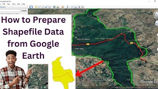

How to prepare shapefile data from Google Earth@geospatialtools2912
Переглядів 5329 місяців тому
In this video, you will learn how to create shapefiles data from Google Earth. The video covers the following steps such as (1) drawing a polygon and line in Google Earth, (2) saving the polygon and line as a KML file, and (3) converting the KML files to a shapefile. Shapefiles are a common file format for storing Geographic Information System (GIS) data. They are used by a wide variety of GIS ...

How to download and prepare a high-resolution LULC map for your study area: very easy and short
Переглядів 2,2 тис.Рік тому
This tutorial is to show you how to download a high-resolution Land Use and Land Cover (LULC) map with a 10-meter resolution from ESRI, and then guide you on how to prepare the data for your specific study area. LULC maps are crucial for various research purposes, from environmental studies to urban planning, and having a detailed map can significantly enhance the accuracy and reliability of yo...

How to use GIS-based SWPT tool for Subwatershed Prioritization
Переглядів 1,6 тис.Рік тому
This video is to show you how to prioritize sub-watersheds for conservation using the powerful GIS-based SWPT (Subwatershed Prioritization Tool). In this informative video, you will explore how this automated GIS-based tool helps you to identify and prioritize critical sub-watersheds. The tool computes all subwatershed morphometric and other parameters at once.

Step-by-Step Guide: How to Download 30m Spatial Resolution DEM Data from USGS Website
Переглядів 577Рік тому
Welcome to the Geospatial Tools UA-cam channel! In this video, I will walk you through the process of downloading 30-meter resolution Digital Elevation Model (DEM) data from the official United States Geological Survey (USGS) website. Whether you're a geospatial enthusiast, a researcher, or someone curious about elevation data, this tutorial will provide you with the necessary steps to access a...

ArcMap Map Layout Tutorial: how to design beautiful map layouts for print
Переглядів 408Рік тому
In this comprehensive tutorial, I will walk you through the step-by-step process of designing visually appealing maps that you can print or export for your projects. From adding data layers and symbolization to arranging map elements and customizing their appearance, it covers everything you need to know to create professional map layouts. Whether you're a GIS enthusiast, a cartographer, or a p...

How to Perform Spatial Queries Using ArcMap
Переглядів 638Рік тому
In this tutorial video, you will learn the process of performing spatial queries using ArcMap. You will learn how to filter features from a layer using a spatial query. The spatial query is a process of selecting a subset of features or records from a layer or table based on attribute values and spatial relationships. It allows you to filter data and focus only on the information that you need ...

Image Preprocessing: How to Clip Multiple Bands at Once Using QGIS
Переглядів 1,5 тис.Рік тому
In this tutorial, you will explore how to clip multiple bands at once in QGIS, a free and open-source Geographic Information System (GIS) software. Clipping is a common preprocessing step in image analysis, where we extract a portion of an image within a defined boundary. Related content: Step-by-Step Guide: How to download Sentinel, Landsat, ASTER, and MODIS data using SCP of QGIS: ua-cam.com/...

Step-by-Step Guide: How to download Sentinel, Landsat, ASTER, and MODIS data using SCP of QGIS
Переглядів 2,2 тис.Рік тому
In this video tutorial, you will learn how to download Sentinel, Landsat, ASTER, and MODIS satellite data using the SCP (Semi-Automatic Classification Plugin) of QGIS.
Applications of Remote Sensing: An Overview
Переглядів 811Рік тому
This video is about major application areas of remote sensing technology
Top 3 Geospatial Technologies: GIS, Remote Sensing, and GPS
Переглядів 2,3 тис.Рік тому
In this video, you will explore the top three geospatial technologies that have made a significant impact in the industry. You will discuss Geographic Information Systems (GIS), Remote Sensing, and Global Positioning Systems (GPS), their key features, and wide-ranging applications. These technologies have revolutionized the way we collect, store, process, analyze and visualize spatial data. Joi...
How to Create a Subset of Remote Sensing Data using ERDAS IMAGINE 2014
Переглядів 1 тис.Рік тому
This video tutorial is to show you how to create a subset of remotely sensed data using ERDAS IMAGINE 2014. The benefit of creating subsets improves processing speed and reduces file sizes. Don't forget to like and subscribe for more tutorials on GIS and remote sensing analysis and image processing with ERDAS IMAGINE.
Layer stacking Spectral Bands with ERDAS IMAGINE, How to Fix Unsupported Compression Type -Part 1
Переглядів 3,4 тис.Рік тому
In this tutorial, I will show you how to layer-stack Landsat 8 spectral bands of the Landsat image using ERDAS IMAGINE 2014. Layer-stacking is a process of combining multiple images, such as spectral bands, to create a single image with multiple layers. This technique is often used in remote sensing applications to enhance the visual representation of the data. Don't forget to like and subscrib...
Very easy and short: How to combine/mosaic multiple raster data into a single raster
Переглядів 501Рік тому
This video tutorial is to show you how to combine/mosaic multiple raster data into a single data. This can be useful for many applications, including creating large-scale maps, combining aerial or satellite images, and creating composite images for data analysis. Related video tutorials: Define projection, and project raster and vector data using ArcGIS software: ua-cam.com/video/JpeT-ExvFSo/v-...
Raster data reclassification and area calculation for each class using ArcGIS software
Переглядів 5 тис.Рік тому
This video tutorial is to show you (1) how to reclassify raster data into different user-defined classes and (2) how to calculate the area and percentage of each reclassified class
Spatial Interpolation (IDW and Kriging) using ArcGIS software
Переглядів 2,6 тис.Рік тому
Spatial Interpolation (IDW and Kriging) using ArcGIS software
Data Conversion (Vector to Raster conversion and vice versa) using ArcGIS software
Переглядів 4,2 тис.Рік тому
Data Conversion (Vector to Raster conversion and vice versa) using ArcGIS software
Raster Data Extraction using ArcGIS software
Переглядів 766Рік тому
Raster Data Extraction using ArcGIS software
Working with Geoprocessing Tools in ArcGIS software
Переглядів 3,4 тис.Рік тому
Working with Geoprocessing Tools in ArcGIS software
Working with Geodatabase, Feature Dataset and Feature Class
Переглядів 1,5 тис.Рік тому
Working with Geodatabase, Feature Dataset and Feature Class
Georeferencing raster data, creating and editing features from the georeferenced/existing data
Переглядів 3,1 тис.Рік тому
Georeferencing raster data, creating and editing features from the georeferenced/existing data
Define projection, and project raster and vector data using ArcGIS software
Переглядів 598Рік тому
Define projection, and project raster and vector data using ArcGIS software
Step-by-step Procedure of Multi-criteria Decision Making (MCDM) analysis using GIS and AHP - Part 2
Переглядів 24 тис.2 роки тому
Step-by-step Procedure of Multi-criteria Decision Making (MCDM) analysis using GIS and AHP - Part 2
Step-by-step Procedure of Multi-criteria Decision Making (MCDM) analysis using GIS and AHP - Part 1
Переглядів 34 тис.2 роки тому
Step-by-step Procedure of Multi-criteria Decision Making (MCDM) analysis using GIS and AHP - Part 1
How to download river shapefile for any area
Переглядів 8 тис.2 роки тому
How to download river shapefile for any area
How to Clip Multiple Shapefile Layers at Once using QGIS 3.24 and ArcGIS 10.8 Software
Переглядів 1,9 тис.2 роки тому
How to Clip Multiple Shapefile Layers at Once using QGIS 3.24 and ArcGIS 10.8 Software
How to Create and Digitize Point, Line, and Polygon Shapefile Layers Using QGIS Software
Переглядів 1,5 тис.2 роки тому
How to Create and Digitize Point, Line, and Polygon Shapefile Layers Using QGIS Software
How to know the location of your study area in Degrees, Minutes and Seconds (DD MM SS) using ArcMap
Переглядів 1,8 тис.2 роки тому
How to know the location of your study area in Degrees, Minutes and Seconds (DD MM SS) using ArcMap
ERDAS IMAGINE Software @geospatialtools2912
Переглядів 8042 роки тому
ERDAS IMAGINE Software @geospatialtools2912
Watershed stream order map preparation from DEM data using ArcGIS Software
Переглядів 20 тис.2 роки тому
Watershed stream order map preparation from DEM data using ArcGIS Software
Thank you Very much, great job keep it up.
Thanks for your tutorial but, the sound is zero
It nice. Could you show us about ROC validation technique Please?
Please send me the table
telegram channel link...pl send
Excellent presentation...Pl share the excel file or the link
sound
Very nice lecture thnak you
ممكن بالعربي لا افهم شي واحتاجه
Great teaching....thank you very much colleague...stay blessed friend..
Watershed shape file kese liya
Very helpful video for prioritization.
Excellent and clear explanation I potentially use it for my thesis thanks for your language too
Wow
Tx ❤ so much easyer ❤❤❤❤
google spread sheet not showing
You have the option to download from the provided Telegram channel link. You can find the associated Telegram channel link in this UA-cam channel's description section.
I am working on a suitability analysis using the Weighted Overlay method in ArcMap based on the Analytic Hierarchy Process (AHP). After performing the study, I encounter issues when classifying and visualising the output. Here are the problem details: When attempting to classify the Weighted Overlay output, I receive a prompt to compute the histogram. Upon clicking "Yes," the software fails to initialize the classify renderer and displays an error message stating: “Failed to initialize classify renderer (possibly too many unique values).” The output data appears to have a very high number of unique values, which seems to be causing issues with classification and visualization. The classification settings are not rendering the data properly, and the map APPEARS EMPTY. What could be the problem? I've failed to get an output suitability map. I have 16 factors.
Hello, Hope you are doing well, Can you please send me the excel file that you used I would be extremly grateful to u Thank u
You have the option to download from the provided Telegram channel link. You can find the associated Telegram channel link in this UA-cam channel's description section.
Nice
I understood all the steps, but I didn't understand your language. Your video helped me a lot 👍👍👍👍
Thank you, it was clear and very important. 🙏🙏🙏🙏
Thank you 🙏🙏
great!!
Greetings sir, can I get the excel AHP Table, because the link above can't access
You have the option to download from the provided Telegram channel link. You can find the associated Telegram channel link in this UA-cam channel's description section.
How can we get weighted factor value?
You can watch a video titled "Step-by-step Procedure of Multi-criteria Decision Making (MCDM) analysis using GIS and AHP - Part 1" in this UA-cam Channel to easily understand how to assign weight of influence for each factor.
I need Narmada basin DEM file. I download it from open topography but this is not working on it. please help
Sir, it says that the document is deleted. Would you mind sharing it again? Thank you
You have the option to download from the provided Telegram channel link. You can find the associated Telegram channel link in this UA-cam channel's description section.
That's very helpful.
🎉🎉🎉
thank you for the method,the ahp table don't work if you can resend that will great for your part
You have the option to download the AHP template from the provided Telegram channel link. You can find the associated Telegram channel link in this UA-cam channel's description section.
From where you download basin shape files..... incomplete information
Search "HydroBASINS" from Google.
There's no sound in this video,
How we do accuracy assessment of this type of downloaded classified maps
can you please share the spreadsheet
You have the option to download from the provided Telegram channel link. You can find the associated Telegram channel link in this UA-cam channel's description section.
best
Hello brother could you please contact me, I wanna discuss with you about some issue
Sir please make vdo in English ur reach will also increase
Which version of semi automatic classification you used for downloading images?
Sir pls can u share the excel file..for thesis purpose only,,,the link provided says it has been deleted
You have the option to download from the provided Telegram channel link. You can find the associated Telegram channel link in this UA-cam channel's description section.
Sir can you please creat English language for us 🙏🙏
Can we do this on qgis
Great video. Thank you.
Sir how do we need to write 1 to 9 criteria in the pairwise Matrix in the first step
i have run this model but fail to generate result...please help is it compulsory to have ArcGIS 10.2
Good Explanation.
ua-cam.com/video/0r-YhP6iY-Q/v-deo.html
Failed to execute, why?
Sir how to download SWPT please share process
Excellent sir Though I am not familiar with your language
Thanks a lot, sir, I'll always oblige to you