
- 115
- 278 050
Quantum Land Design
United States
Приєднався 20 лют 2019
Get the most out of the latest GPS machine control and drone technology.
NEW - DJI Mavic 3E IMU, Gimbal and Compass Calibration
Quickly and easily calibrate your Quantum Flight Pack's IMU, Gimbal and Compass.
You may need to perform these proedure when prompted by the system. It's a good idea to calibrate everything anytime the drone is shipped or handled roughtly.
This video shows DJI Pilot 2 software on a Mavic 3 Enterprise (M3E).
Free machine control and drone data resources - www.quantumlanddesign.com/education
Quantum Flight Pack Details -
www.quantumlanddesign.com/quantumflightpack
Machine Control Models -
www.quantumlanddesign.com/machine-control-data-prep
Email sales@avqld.com with questions.
Переглядів: 2 717
Відео


NEW - DJI Mavic 3E Switch Camera to Jobsite Photos
Переглядів 1,7 тис.Рік тому
The Quantum Flight Pack can capture jobsite photos and video just as well as you can topo your projects. Changing just a handful of settings will set you up for crystal clear photos of any project. You can even use the impressive zoom capabilities of the Mavic 3 E for inspections. We are showing DJI Pilot 2 on a Mavic 3 Enterprise (M3E) here. The settings changes are similar for any mapping cap...

NEW - Quantum Flight Pack Tailgate Intro - DJI Mavic 3E
Переглядів 720Рік тому
What's in the Quantum Flight Pack you ask? It's a fully updated and tested drone system designed for contractors. You won't be missing a thing when you head out to fly your first project. The best part? NO SUBSCRIPTION FEES!! Fly your sites to determine earthwork volume calculations, stockpile calcs even calculate production in conjunction with your GPS machine control system. Free machine cont...

NEW - DJI Mavic 3E Firmware and FlySafe Update
Переглядів 1,7 тис.Рік тому
Quickly and easily update your Quantum Flight Pack to the latest firmware and FlySafe databases. Have the batteries charged and a good Wi-Fi connection before you start. This video shows DJI Pilot 2 software on a Mavic 3 Enterprise (M3E). Free machine control and drone data resources - www.quantumlanddesign.com/education Quantum Flight Pack Details - www.quantumlanddesign.com/quantumflightpack ...

DJI In-Flight Monitoring
Переглядів 306Рік тому
A quick walk-through explaining the information available on the controller during a topographic mapping mission. We are showing DJI Pilot 2 on a Mavic 3 Enterprise (M3E) here. Similar information will be available in Ground Station Pro for older DJI drones with mapping capabilities. Free machine control and drone data resources - www.quantumlanddesign.com/education Quantum Flight Pack Details ...


DJI Mavic 3E Camera Settings for Topographic Survey Mapping
Переглядів 13 тис.Рік тому
DJI Mavic 3E Camera Settings for Topographic Survey Mapping
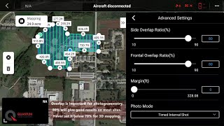
DJI Mavic 3E Flight Planning for Topographic Survey Mapping
Переглядів 22 тис.Рік тому
DJI Mavic 3E Flight Planning for Topographic Survey Mapping

How to Operate a Caterpillar D9 Bulldozer
Переглядів 8 тис.2 роки тому
How to Operate a Caterpillar D9 Bulldozer
Topcon - Saving Topo Shots - Pocket 3D
Переглядів 1,3 тис.2 роки тому
Topcon - Saving Topo Shots - Pocket 3D
Topcon - Change UHF Channel with TRU
Переглядів 2,7 тис.2 роки тому
Topcon - Change UHF Channel with TRU
Komatsu/Topcon - How to Make a Surface Active
Переглядів 4532 роки тому
Komatsu/Topcon - How to Make a Surface Active
Komatsu/Topcon - UHF Radio Troubleshooting
Переглядів 5 тис.2 роки тому
Komatsu/Topcon - UHF Radio Troubleshooting
Komatsu/Topcon - Blade Height Adjustment
Переглядів 4,1 тис.2 роки тому
Komatsu/Topcon - Blade Height Adjustment
Komatsu/Topcon - Adjust Vertical Offset Increment
Переглядів 4,2 тис.2 роки тому
Komatsu/Topcon - Adjust Vertical Offset Increment
Komatsu - How to Use IMC 2.0 Features
Переглядів 15 тис.2 роки тому
Komatsu - How to Use IMC 2.0 Features
Komatsu/Topcon - Load a TP3 Project File
Переглядів 4,4 тис.2 роки тому
Komatsu/Topcon - Load a TP3 Project File
John Deere - SmartGrade Virtual Warnings - 470G Excavator
Переглядів 1,1 тис.2 роки тому
John Deere - SmartGrade Virtual Warnings - 470G Excavator
John Deere - SmartGrade Automatic Control - 470G Excavator
Переглядів 1,8 тис.2 роки тому
John Deere - SmartGrade Automatic Control - 470G Excavator
John Deere - SmartGrade Key Settings - 470G Excavator
Переглядів 1,8 тис.2 роки тому
John Deere - SmartGrade Key Settings - 470G Excavator
John Deere Bulldozer - 2D Basics - SmartGrade
Переглядів 13 тис.3 роки тому
John Deere Bulldozer - 2D Basics - SmartGrade
Waecheter Reclaimed Mine Site 2- Delong Construction
Переглядів 403 роки тому
Waecheter Reclaimed Mine Site 2- Delong Construction
Waecheter Reclaimed Mine Site 1- Delong Construction
Переглядів 263 роки тому
Waecheter Reclaimed Mine Site 1- Delong Construction
Waecheter Reclaimed Mine Site 3- Delong Construction
Переглядів 273 роки тому
Waecheter Reclaimed Mine Site 3- Delong Construction
Good job thank you 💪
Glad you found it useful!
dji mavic 3E custom RTK HI Target V300.?
How I can get off set in any line?
You can select the line, hold down on the screen and a menu will pop up. From there you can stake the line.
POWERFUL
Short and sweet. Thanks for this as my current settings aren't anywhere near suitable.... (horrendous BLOTCHED imagery) is causing me a nightmare. I'll give these a go. So you literally have to go through this process at each takeoff/resume/battery change? It's another level of tedious setup, but if it resolves terrible imagery, I'll do it!
If you get the settings right the first time you can usually just set the EV value at each battery change and be good to go. If your images are blurry you may have to slow of a shutter speed or flying too fast.
What software do you use to process these images into a orthophoto or digital elevation module?
We use Pix4D products and a variety of CAD software packages, depending on the deliverables required.
Thank you for the video. How do you check the wind speed and direction?
Two ways, most weather apps will give you a general idea of conditions you can expect through the day. Then adjust to conditions where you are flying. There are several drone specific apps, too. Just search for them and pick the one you like.
Does John Deer smartgrade connect to a VRS network?
MAN I WISH I COULD GET SOME WORK WITH OR FROM YOU GUYS
Heh man I love your video but I wanna see how ripping works do that for me in another video
Thanks, we'll see if we can make that happen.
Why are we checking into control sites?
Hi @aidanwaldron3501 - We check into control to make for certain our GPS system was/is correctly calibrated to the site. That way, our topo will be compatible with any data collected before or after your current days' work.
Well articulated thanks a lot for the wonderful insights
Thank you, glad it was helpful.
Lost me at 13 seconds. Set up an account with your network provider? Who is that? How do I get a network provider?
It will depend on where you live. You might need to subscribe to a NTRIP provider, or you state DOT may offer a free service.
Good
NICE
What does vertical offset do?
It adjusts your finish grading surface up or down to compensate for the thickness of rock, pavement or topsoil.
So show the topographic pic and show the NO-WARPING orthomosaic...
You are right, those orthos can get distorted without ground control.
Please help! where can I get the configuration for my device? tq sir
You will have to reach out to your CORS network provider to make an account and connect to their network. It's the same process a surveyor would use to connect a network rover. Depending on your location you may have to pay a subscription fee.
Really helpful information,
Glad it was helpful and thanks for letting us know.
How do you get the oblique option on the map? When I go to create a new route all I get is the options for waypoint, area route and linear route
Firmware update combined them. Tap the "Area Route" option, draw your shape, select your drone, then you will have the option for Ortho collection which is what he did in the video, or Oblique Collection. Further down will be the option for Smart Oblique as well.
Talking about what your doing is a thing of the past.
nice chem trails in the background
Thanks, nicely explained. useful today also. just a quick question- in 3D surface mapping "Shooting Angle" & "Gimbal pitch angle" does affect the final output?
It does. For topographic mapping you should keep it set at -90 degrees (straight down).
The one I'm running just stopped working. I press auto and the blade does nothing. It's weird because it worked fine all week.
Thats a drag. I'd suggest starting simple and checking any fuses tied to the system. Troubleshoot your way up from there.
What do you enter for mountpoint? I am using Massachusetts macors. I found the closest tower name and what i believe is the port info. I entered RTK for the mountpiece. I actually did this in my house near a window. It didn’t appear to be doing anything. Funny thing is a few minutes later it said manned Aircraft in area use caution, and right then i could actually here a small plane fly by. I shut everything down to try and do it again but the second time it never connected. I think i may have to take it outside. But still undure about mountpiece, and you never mentioned it in the video. Thank you
Hi @drumatruka - I'd suggest dropping an email to the CORS support folks at the state. The mountpoint you use can change the base selected and satellites used among other things. You should be able to choose a mountpoint that either picks the nearest base or VRS and uses all satellites available in the MA system. Take the system outside for all validation tests. Indoor tests are never reliable.
thanks, Thats what I did and now I am connected. Thank You @@QuantumLandDesign
It won’t even let me hit the start button it just sits on that screen it won’t do anything it’s not frozen because I can still bac out and do everything else it just won’t let me hit start on the IMU
Seen that before. Did a re-start fix the problem?
What would you recommend for topographic surveys of farm land that have quite significant changes in elevation? I ran into an issue on my first attempt yesterday with my M3M where the hills/mountains had about 300m of elevation gain so the mission would keep halting because the drone didn't stay a consistent distance from the ground below (as in as the terrain got steeper, the drone got closer to it - ie. staying at the same elevation from the take off point)
Hi @paulbaker7489 - You can use the terrain follow functionality or load your own surface DSM. Be careful with DSM's from online sources. If you are flying an area the frequently changes, like mine, it may not be accurate. As always, keep line of site to closely monitor the drone as you fly.
@@QuantumLandDesign still struggling to find the Terrain Follow function. Will see if DSMs exist if rural Colombia!
@@paulbaker7489 , sorry I forgot they changed it to AGL (above ground level) in the last update. It's under the ASL/ALT menu section when planning a mission. Again, keep close eyes on the drone when using this function!
Hi Great video, one question through. If you use all 5 control points, what do you do regarding the level? as we all know that GNSS level has more tolerance than in the x,y plane. Especially when you then traverse around with an EDM. What do you do? Thanks.
Hi @petertips2686 - I am not sure I understand your question. If you use x,y,z for all five (or more) control points you should be good to go. To tie verticals down as tight as possible you can request the surveyor run a level loop to tighten them up. At the least, we like to see them use a robot to set your control. The length of time you spend shooting in each point matters, too. Recommendations vary by manufacturer, but always spend at least 30 seconds on each CP. We usually occupy the point for two minutes to better average out the error. If you have a "bad" control point your GPS system should show you excessive error on that point (but you will need at least 4 shot in before it will display vertical error). Keep in mind that some variance and tolerance stack up is inherent in GPS.
Is it not possible to take pictures in 16x9? On my 3E, I only have 4x3 and can't switch it.
4:3 is the only option on the M3E.
New to automated mapping. I’ve been doing telecom site audits for the past 3 years. I recently have done some automated mapping missions and I am dealing with the client sending jobs back due to blurry photos. My camera settings are set to auto. Mechanical shutter is toggled on as well. Is it the gospel to have camera settings on S mode when mapping vs auto?That way I know going forward and can let other pilots know as well.
how can i setup msl height?
Thanks for posting this. Super helpful!
How do I get the blade height adjustment as I can’t find it on my top on gps
Kyle explains it here - ua-cam.com/video/gBsMq9YxxVI/v-deo.htmlfeature=shared&t=27
My calibration gets up to 25% then gets stuck in mini shakes and fails calibration after a few minutes of being stuck.
If it did not come around after a re-start you might need to send it in to DJI for repair.
Hello Thank you for this video. However, I can’t access the dji pilot app with my m210 RTK - it says it’s not the right app. Can this setting also be found and changed in the dji go 4 app? I can’t find it…
Thank you for this. Just got my M30T and want to try RTK with the DJI RC Plus controller. I live in Knoxville, TN and the only site I could find with current networks is Tennessee's DOT map of CORS networks. I'm not sure if CORS applies to RTK for drones and truthfully don't know what I'm even looking for. I tried the MatricePilots forum but that place is a ghost town. If CORS is not the right thing to be looking for, would you know where to look for the city of Knoxville area? Thanks for any advice or tips.
Hi @gsquared_08 We can't speak specifically to the TN network but I'd suggest you start here -www.tn.gov/tdot/roadway-design/survey-standards/gnss-reference-network.html There is an email and phone # where you should be able to get the answers to your location specific questions. The TN CORS network should broadcast the information you need to connect any RTK capable DJI drone.
Top
Have you used Flighthub 2? I just purchased 1 month and it seems to still have a lot of bugs. Should be still in beta. The area route function is not available even in the paid version.
We have not tried Flighthub 2. Often, we'll let new apps mature for about 6 months before we really dig in.
I have an issue where when I try to hit the joystick button to enable a matched slope. It tells me blade heading lost and to blade to the left most extent and then to the right but it never sets. What am I supposed to do for the machine to calibrate and find the blade heading?
❤❤
How much is this drone system
Hi - drop me an email at sales@avqld.com. We'll get right back with current pricing.
❤this good information
Thanks, glad you are getting some value from it.
This teaches absolutely nothing. How do you export just a certain number of points like if I have 1 to 5000 and I want to export 4000 to 5000 that'd be helpful
I'll see if we can do a more detailed video next time we get ahold of a controller. In the meantime, it's often best to export all points, then delete what you don't need in excel. That way you don't leave the field short any information.
*Promo sm* ⭐
12:29 Barstool analogy perfect!!
Figured the audience would relate!
what software is that? 3DMC?
It's similar. Komatsu changed a few things up to add their features. The core functionality and menus are very similar to the layout Topcon has maintained for years.
Very helpful. Mine shows 40 satellites on the rtk but it says not connected. Do you happen to know why this may be?
First, I would triple check that you have the NTRIP network information entered correctly and steady internet connection.
Hi, Thank you for your tutorial. They are beneficial. Will you please make one for the 3D Oblique Mapping setting? Appreciate it.
Hi Touraj - We'll add that one to the list. Keep an eye out.
@@QuantumLandDesign thanks 🙏
why didnt you use grid pattern when planning mission?
For topographic flights it's not necessary so long as you have sufficient side/front overlap. If you are trying to capture very steep terrain or building facades, you may want to consider a grid flight. We've experimented with grid flights for topos and do not see an improvement in most use cases.
Like!you made cool !
Nice and short, but I was looking for more. Just got my 3E and wanted to see how you set your camera settings, etc. Like what controls are you using. A walkthrough.
Thanks for watching, glad we could get you started. Keep an eye out. We will continue to add more videos as time permits.