

- 15
- 42 830
Ehsan Jalilvand
United States
Приєднався 4 лис 2021
ChatGPT and Google Earth Engine: A Match Made in Heaven for Satellite Image Processing
ChatGBT, Google earth engine, Satellite Image Processing
In this video, I show how ChatGPT and Google Earth Engine can Make Satellite Image Processing like never before!
In this video, I show how ChatGPT and Google Earth Engine can Make Satellite Image Processing like never before!
Переглядів: 28 015
Відео
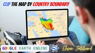

Clip by Country boundary in Google Earth Engine
Переглядів 8 тис.3 роки тому
Google Earth Engine, Clip, Country Boundary, map, cloud computing Hello everyone in this tutorial I explain how to use a predefined country boundary layer in the Google Earth Engine to clip your map. Here is the link to the code: bit.ly/3fkGFqx

4th Agricultural revolution, The role of soil moisture remote sensing
Переглядів 1333 роки тому
Agriculture 4.0, Satellite Imagery, Invited Talk, University of Tehran

Google Earth Engine, improving land use classification (Part 4)
Переглядів 2313 роки тому
Google Earth Engine, GEE, Satellite Imagery, landuse calssification, cloud computing
Google Earth Engine, image classification (Part 3)
Переглядів 1653 роки тому
GEE, Google Earth Engine, satellite imagery, landuse classification, cloud computing

Google Earth Engine , JavaScript API (Part 2)
Переглядів 2333 роки тому
GEE, Google Earth Engine, Satellite imagery, Sentinel 2, cloud computing Introducing Earth engine panel 1:25 JavaScript coding essentials 5:05 Saving your script 21:00 Sharing the script link 23:31 Adding a location using search bar 25:10 Adding Sentinel 2 data using search bar 27:25

Google Earth Engine, a quick start (Part 1)
Переглядів 2683 роки тому
Google Earth, Engine, satellite Imagery, Time Lapse, cloud computing

Processing NetCDF files with MATLAB (part 3)
Переглядів 2,4 тис.3 роки тому
MATLAB, Satellite imagery, NetCDF Downloading and subsetting precipitation data in GES DISC 00:50 Downloading MODIS NDVI and LST from Appears 12:10 Reading multiple files from a folder 14:32 1st Exercise: Extracting netCDF information and variables 19:30 Reading NetCDF data 27:30 Looping through multiple NetCDF files 39:50 Saving all the data in *.mat format 50:00 Plotting the data 58:00 Plot t...

GeoTIFF processing with Matlab (part 2)
Переглядів 4723 роки тому
Matlab, Satellite Imagery, GeoTIFF, Multiple files Reading all images in a folder 3:20 Filter files by names and extensions 6:55 Processing file names 10:25 Extracting dates from filenames 14:25 Serial date number 17:52 Looping through all images 24:24 Create a data cube 34:15 Averaging all images in time 41:45 creating multiple maps (subplot) 50:50 Creating LST time-series of one pixel 56:30 D...
Satellite Image processing with Matlab (Reading, Plotting and Writing a GeoTIFF file)-Part 1
Переглядів 2 тис.3 роки тому
MATLAB, Satellite Imagery, Persian Language Video contents: 1. AppEARS 3:26 2. Download multiple satellite images 11:40 3. Read GeoTIFF 21:40 4. Finding scale and offset 37:30 5. Meshgrid 52:33, 57:23 6. Pixel coordinate from a Geotiff 54:16 7. Plotting satellite image 1:02:43 8. colorbar 1:20:05 9. colormap 1:28:06 10. Writing Geotiff 1:31:06
How to download and customize satellite data from NASA EARTHDATA and AppEARS - Part 4
Переглядів 1203 роки тому
Satellite Imagery, Earthdata, NASA, Satellite data download در این ویدیو نحوه دانلود تصاویر ماهواره ای از سایت EARTHDATA و AppEARS آموزش داده می شود.
Introducing Environmental Monitoring Satellite missions (part 3)
Переглядів 903 роки тому
Satellite Imagery, Environmental Monitoring, NASA, ESA, Copernicus در این ویدیو به معرفی ماموریتت های ماهواره ای با هدف پایش منابع آب و محیط زیست پرداخته می شود. Environmental and Water resources monitoring satellite missions are introduced in this video.
Satellite Image Characteristics (in Farsi) - Part 2
Переглядів 1033 роки тому
در این ویدیو تفاوت ماهواره و سنسور، مدار حرکت ماهواره ها، سنسورهای فعال و غیر فعال، مشخصات تصاویر ماهواره ای مانند قدرت تفکیک مکانی، زمانی، طیفی و رادیومتریک و سطح پردازش تصاویر ماهواره ای با ذکر یک مثال توضیح داده شده است. This video is the second part of the "introduction to the remote sensing of the environment" course that covers satellite image characteristics such as Orbit, Spectral, Spat...
Introduction to remote sensing (Electromagnetic wave, emissivity, reflectance) - part 1
Переглядів 1643 роки тому
Satellite Imagery, Electromagnetic wave, NASA In this video, I have presented a quick introduction to Electromagnetic waves, how we see things in different colors, and how satellites can observe earth features that our eyes can't! The video is in Farsi and it was prepared for the class of 2019 of water resources and environmental engineering students at Amirkabir university of technology.
To do this, you need the image to clip to be the result of a function. How would you clip if the input image is not a function but simply a single land cover map?
Did you use a free ChatGPT account or a scribed one?
Thanks. It is really good.
I am working on a megalithic project, primarily in Google Earth Pro. I have found some really interesting connections linking quite a few megalithic sites (essentially using geodesic "planes", as best as I can inside of the base G.E.P. to draw "lines" on the surface of the earth) to accurately link these ancient sites (it's shocking how accurate these links are). Would it be difficult to implement this data so that AI could be used to potentially find other megalithic sites? I am finding a lot of megalithic sites along these lines. However, I feel like I am missing quite a few connections and want to double-check my work and also make sure it's as accurate as it can be. Thank you, I know these questions are not exactly related to your great video.
ممنون آقا احسان عزیز
Try to do in English version.
سلام ممنون برای وقتی که گذاشتید. Hi, thanks for thanking Time.
دمت گرم
جلسات دیگر مباحث تون و از کجا بگیریم؟
سلام بقیه پلی لیست ها رو نگاه کنید، همه اش همین جا هست.
خیلی خیلی ممنون@@ehsanjalilvand6816
what is clip?
Good Luck
Very informative video. Thanks. Do you know if clipping can be done this way according to US states?
hey i have generated the chart but the mean lst values are on Yaxis is showing 14,000 to 16000 and when i try to lower them the color on map do not display correctly.
Can you clip the modis to multiple countries in one file? Rather than a single map for each country individually. I'm needing to include 13 countries in a study and would rather they all be in one exportable file, rather that 13 individual ones. Thank you!
kkk. Sou preguiçoso.
More about The combination of GEE and ChatGpt
Wow Can you drawing cad 3d part into earth using gpt ? Ex cube 3d in my garden ? If you realize tutorial tag me please ... thank you
It is really awesome. Thank you for sharing.
Too bad OpenAI services are not available in my country :(
there are workarounds
@@jasonrist6582 they are hard as hell
Thank you for sharing such a practical tutorial.
You're very welcome, Babak jan!🙏🏻
great tutorial, I'm a back-end developer and have recently found chatgpt a let's say cool assistant in different areas however in many cases it may get confused and return either wrong or unwanted results. in terms of GEE I think it still needs to be trained.
I agree, I provide some suggestions in response to Sarel comment that might help.
i have been trying the code generated using chatgpt but none of them has worked i have tried atleast 10-15 different codes
That is true, some times chatGPT’s suggestions are not simply working, here are some suggestions that worked for me and might help you: 1. Do not ask long complicated questions, give information and ask questions one at a time and start from simple questions. 2. As chatGPT consider the history of the chat with you, your few first questions can put it on a right/wrong track, sometimes it is good to edit the questions, for example see how I edit my question at 7:30 and finally got the right answer. 3. Sometimes the code is not working but if you are familiar with the language you can get some good ideas that can help improve your coding.
What I learned from this video is that: I'm still in my pre-internet era using ArcMap and ERDAS for my project while this man straight up doing Tony Stark and Jarvis thing.
LOL! 😂 All of those skills are still useful, chatGPT is just one more tool in your toolbox.
thanks dr jalilvand
Thank you for this
Salam vaght bekheyr
Nice share
Wow
it was really awesome! XD by the way, its not available in Iran :D
Please give pm2.5 estimation in gee by chatgpt
You can try something along these lines in chatGPT: - I want to make a pm2.5 map in earth engine, and make a median map for Hong Kong for 2020, can you write the javascript code? Sometimes it is difficult for chatGPT to find the right data collection, you can search the data collection in GEE yourself and suggest them to chatGPT in your next request, for example: - use this data collection: ee.ImageCollection("ECMWF/CAMS/NRT"), the pm 2.5 layer name is: particulate_matter_d_less_than_25_um_surface
Great video, thank you. Can you please explain me how to make GEE to automatically suggest functions while typing, like the ee.Filter.eq? When I start typing sth. like this, nothing happens. Thanks!
Thank you! you can type a few first letters then press ctrl+space
@@ehsanjalilvand6816 Thanks :)
How would you combine multiple country boundaries?
Very informative and helpful! Thank you!
خوش آمدید، استاد ممکن است ایمیل با شما ارتباط برقرار کند
Hey, can you please explain the LST part as well, how can we do it for another country?
Hi Kavya, Thanks for your comment, I will add a video for the LST part as other people also requested. But for changing country just find your country code from FAO table (explained at 2:40) and then replace 117 at the end of the first line with the number that you find for your country from the FAO table. The code link is in the description.
dont have the english version of the video
Soon I will add the English version, plz stay tuned. BTW, the time stamp in the description might help you to get to the part that you want.
Thnx for tutorial, can u share the codes?